Geological Background
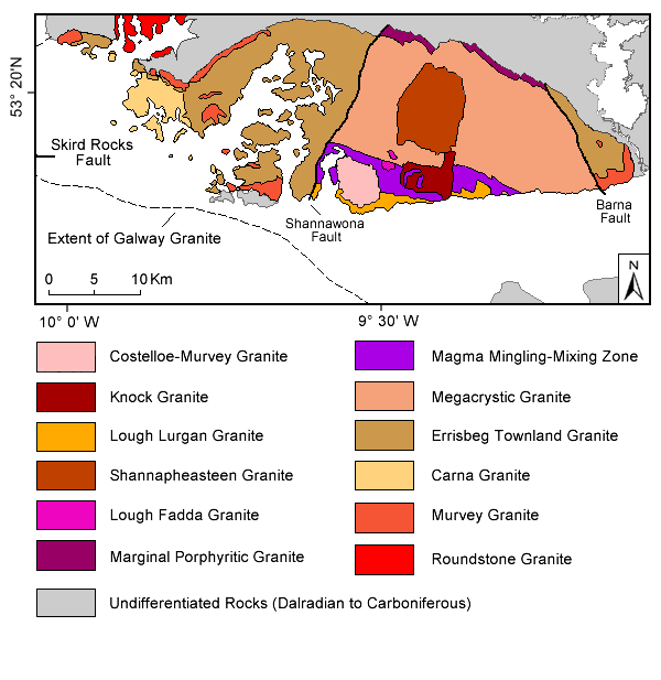
The Galway batholith and its satellite granites (Omey, Letterfrack, Inish and Roundstone granites) located in Connemara are important elements of the late-Caledonian geological history of western Ireland and occupy a key location along the North Atlantic Caledonides (Figure 1). The Galway batholith is a calc-alkaline granite body and was emplaced into the 474.5-462.5 Ma Metagabbro-Gneiss Suite to the north (Leake 1989; Leake and Tanner 1994; Friedrich et al. 1999), and into Lower Ordovician greenschist facies rocks (the South Connemara Group) to the south (McKie and Burke 1955; Williams et al. 1988). The batholith emplacement postdates the Skird Rocks Fault (Figure 2), which Leake (1978) considers to be a splay off the Southern Uplands Fault and to have strongly influenced its siting creating a stitching pluton. The batholith extends for several kilometers beneath the Carboniferous rocks of the Galway Bay area, as indicated on gravity and aeromagnetic maps (Murphy 1952; Max et al. 1983; Madden 1987). The long axis of the batholith is oriented WNW-ESE, oblique to the E-W strike of the Skird Rocks Fault. Two major faults zones, the NNE-trending Shannawona Fault Zone (SFZ) and the NW-trending Barna Fault Zone (BFZ), define the boundaries between the western, central and eastern blocks in the batholith. The SFZ represents a fundamental litho-geochemical discontinuity in the mid-western region of Galway Granite batholith.
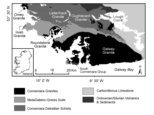
The western and eastern blocks expose granodiorite through granite to alkali granite (Leake 1978). The central block granites have been described in detail by the following: Feely and Madden (1986, 1987, 1988), Whitworth and Feely (1989, 1994), Feely et al. (1989, 1991), El Desouky et al. (1996) , Crowley and Feely (1997), Graham et al. (2000), Baxter and Feely (2002) and Baxter et al. (2005). Baxter et al. (2005) interpret fabrics within the Megacrystic Granite and Magma Mixing-Mingling Zone (MMZ) Granodiorite to reflect ballooning processes operating in successive magma batches (e.g. Megacrystic Granite and MMZ Granodiorite) at the emplacement level. Leake (2006) states that centre and northern margin of the batholith exposes field evidence indicating that the approximately 400 Ma main phase of emplacement was incremental by progressive dyke injection and stoping of the Metagabbro-Gneiss Suite. These earlier granite batches were stoped by the later granite intrusions such as the Costelloe-Murvey Granite (CMG) during a brittle fracture regime (Crowley and Feely 1997). The central block exposes a juxtaposition of earlier deeper level granites with late-stage higher-level granites. The satellite plutons i.e. Roundstone, Omey, Inish and Letterfrack are located to the north and northwest of the batholith (Townend 1966; Leake and Tanner 1994). The Roundstone and Omey plutons are circular granite plugs with diameters of approximately 6 to 7 km. The Inish granite is located offshore with its eastern edge exposed along the western seaboard. The Letterfrack granite comprises three outcrops, which probably represent one pluton in northwest of the Connemara metamorphic complex.
Figure 2. Regional Geology of the Galway Granite Batholith
Regional Geology of the Galway Granite Batholith