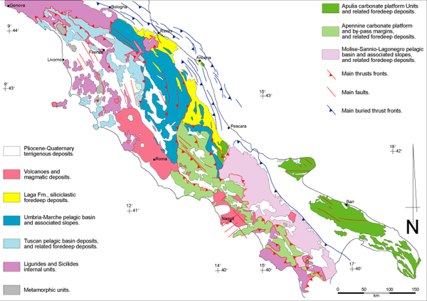
The Apennines (Figure 1) are an east to northeast vergent fold and thrust belt which developed as a result of convergence between the continental margins of Corsica-Sardinia (of European origin) to the west, and of the Adriatic block (of African affinity) to the east, within the general framework of late Cretaceous to Present Africa-Europe plate convergence [e.g. Dewey et al. 1989]. Miocene to Early Pleistocene [Di Bucci and Mazzoli 2002] thrust accretion across the Adriatic (or Apulian) continental margin was accompanied by Tyrrhenian back-arc extension [Mazzoli and Helman 1994, and references therein].
Much of the Apennine chain has been dissected by normal and strike-slip faults that locally post-date thrust structures. In the interior of the chain (e.g. Tuscany), these faults control Mio-Pliocene basins [e.g. Decandia et al. 1998] and therefore are coeval with thrust structures that were active further to the east [Elter et al. 1975]. The thrust front migrated eastward over time, with extension following, so that folds and thrusts along the east margin of the Italian peninsula, which are the products of the final stages of contractional deformation in the Apennines, developed toward the end of the early Pleistocene. At 700-800 ka a major geodynamic change occurred and a new tectonic regime established itself in the Apennine chain and adjacent foothill areas [e.g. Di Bucci and Mazzoli 2002, and references therein]. The structures related to this new regime are characterized by a NE-SW oriented maximum extension direction and consist of normal, oblique- and strike-slip faults that post-date and dissect the thrust belt, and remain seismically active [e.g. Di Bucci and Mazzoli 2002, and references therein].