The third phase comprises a single short stage between chrons M25 (154.3 Ma, Uppermost Oxfordian) and M21 (147.7 Ma, Middle Tithonian), during which Iberia began to separate from North America (150.0 Ma, Lower Tithonian). This event caused the formation of a new transform plate boundary to the North, between Iberia and Eurasia, and the progressive transfer of left-lateral motion from the southern boundary (the former shear zone between Iberia and Morocco) to this newly constituted fault system (Fig. 9). By the end of the stage, any motion between Iberia and Africa ceased, and the existing spreading center of the Liguride Ocean became extinct.
The northern boundary of Iberia during the Jurassic could be represented by the North Pyrenean Fault (NPF), a major vertical structure that several authors assume to be associated with strike-slip motions during the Middle Cretaceous [Choukroune, 1976 ; Teixell, 1998 ; Beaumont et al., 2000]. However, the global kinematic pattern requires that this fault system was active well before the Albian-Cenomanian, because no other major structure has been recognized that could account for the Late Jurassic-Early Cretaceous motion of Iberia with respect to Eurasia. An indirect confirmation of this hypothesis comes from a recent study of calcareous nannofossil assemblages from the Iberia Abyssal Plain [Concheryo and Wise, 2001]. This study shows that the oldest assemblages of calcareous nannofossils in this area are early to mid-Tithonian in age and formed in a restricted interior basin, though open marine conditions were not established until the major Berriasian rifting episode.
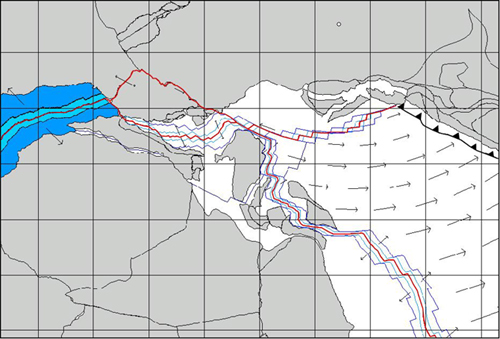
Figure 9. Reconstruction at 147.7 Ma (Middle Tithonian)
Vectors represent direction and magnitude of the relative velocity field between conjugate pairs of plates. Blue line represents the modeled 172.0 Ma, 170.0 Ma and M25 isochrons. The location of the instantaneous Euler pole of relative convergence between Vardar and Eurasia is marked by a small empty circle.
The plate velocity field at anomaly M21 is shown in Figure 9. At this time the Liguride Ocean reached its maximum extension, about 490 Km in the northern part and 640 Km in the southern zones. The spreading rates did not change significantly with respect to the previous stage, ranging from 46 mm/yr in the southern Central Atlantic to 16 mm/yr in the Liguride Ocean.
The acceleration field illustrated in Figure 10 shows the pulse that extinguished the Liguride spreading center in the Western Tethys and that forced the Vardar ridge to re-orient the system of transform faults that connected spreading segments. It is important to note that the model proposed in the previous sections requires that the ridge that existed in the Northern Tethys, between the area to the North of Adria (Alpine Tethys) and the Eastern Pontides, remained stable during the whole sequence of phases that were characterized by a constant subduction rate of the Vardar Ocean. In fact, this complex system of small spreading segments and large transform faults separated Eurasia from Vardar in a way that was kinematically consistent with the invariant stage pole of subduction of the decoupled oceanic plate. Hence, new oceanic crust in the Alpine Tethys continued to be formed until the Lower Aptian, well beyond the time of extinction of the spreading centers that existed in the Western Mediterranean. This persistence of tectonic activity is confirmed by the presence of resedimented materials in the pelagic facies of the South Alpine domain [Winterer and Bosellini, 1981; Santantonio, 1994].
Figure 10. Acceleration field at 147.7 Ma (Middle Tithonian)

Vectors represent direction and magnitude of the relative acceleration field of Africa with respect to Iberia and Eurasia with respect to Africa.