Reconstruction has been performed using PLATYPLUS, a software package developed in the Australian Crustal Research Centre at Monash University (for more information about the PLATYPLUS project see: http://www.virtualexplorer.com.au/PlatyPlus/). The program provides an interactive platform for tectonic reconstruction on a Unix machine. It enables the user to rotate and translate polygons on a spherical Earth. Polygons are chosen based on geological criteria, and their boundaries are digitised and recorded in ASCII files. The objects’ hierarchy is then defined in another file. Once motions are projected on the PLATYPLUS platform, they can be rotated and translated. This can be done either by reading a previously prepared motion file that contains sets of Euler poles of rotations, or by using a manual dragging. Thus, known motions are defined in a motion file and applied accordingly, whereas unknown motions are found by trial-and-error experiments using the best available kinematic constraints. This method provides a continuous updating of the motion file during the reconstruction process. Finally, the resulting reconstruction can be viewed in a movie format.
The most robust data used in plate reconstructions are obtained from the existence of magnetic anomalies in the Atlantic Ocean. Anomalies of similar ages (isochrons) are recognised on both sides of the spreading ridge. Thus, fitting of these isochrons can provide the relative motion of the two diverging plates. However, this method cannot be used for convergent plate margins, and is therefore of little importance in the Mediterranean region. In this reconstruction, the only motions constrained by magnetic isochrons are the relative motions of Africa versus Europe and Iberia versus Europe (Table 1). These data are based on plate circuit calculations described in Rosenbaum et al. (in press).
Figure Table 1. Table 1
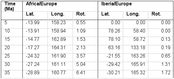
The motions of Africa and Iberia relative to Europe used in the reconstruction (after Rosenbaum et al. in press).
Constraints on the kinematics of deformed allochthonous terranes are obtained from palaeomagnetic studies, which can theoretically provide information about the role of block rotations around vertical axis. However, the regional significance of these rotations in deformed rocks can be ambiguous because of the effect of local deformation. In this reconstruction, we refer only to palaeomagnetic studies that considered the effect of local deformation and provided regional tectonic implications. The amount and timing of block rotations associated with different terranes are presented in Figure 8 and summarised in Appendix 1.
Figure 8. Rotations inferred from palaeomagnetic studies
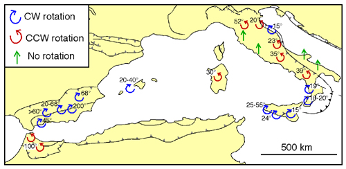
Rotations inferred from palaeomagnetic studies throughout the western Mediterranean. References and time constraints are summarised in Appendix 1.
The role of post-Oligocene block rotations in the western Mediterranean is presented in Figure 8. The rotation of Corsica and Sardinia is relatively well established by palaeomagnetic constraints that indicate ~30° of counterclockwise rotations after the Late Eocene and prior to the Middle Miocene (De Jong et al. 1973, Montigny et al. 1981, Vigliotti & Langenheim 1995, Speranza 1999). It has therefore been concluded that Sardinia and Corsica rotated to their present position during the opening of the Ligurian Sea in the Late Oligocene – Early Miocene. Likewise, the Balearic Islands underwent approximately 25° of clockwise rotation during the opening of Valencia Trough (Freeman et al. 1989, Pares et al. 1992).
Post-Oligocene rotations also occurred in allochthonous terranes of the Rif-Betic cordillera and in the deformed External Zones of the African and Iberian margins. In the Betic cordillera, palaeomagnetic studies implied large amount of clockwise rotations (130° -200°) that gradually decrease towards the distal parts of the thrust belt (Lonergan & White 1997, Platzman 1992, Allerton et al. 1993). At the same time, rocks in the Rif were subjected to counterclockwise rotation in magnitude of approximately 100° (Platzman et al. 1993). In the following reconstruction, we adopt Lonergan and White’s (1997) explanation for the opposite rotational directions on both sides of the arcuate Rif-Betic orogen, which is associated with back-arc extension and a westward subduction rollback.
Most palaeomagnetic results from peninsular Italy show a counterclockwise rotation of the allochthonous Apennines (Lowrie & Alvarez 1974, 1975, Channell 1992, Dela Pierre et al. 1992, Scheepers & Langereis 1994, Iorio et al. 1996, Speranza et al. 1998, Muttoni et al. 2000, Sagnotti et al. 2000). However, clockwise rotations have also been reported in post-Messinian sediments in the Northern Apennines (Speranza et al. 1997). Palaeomagnetic results from the Apennines are probably biased by the effect of local deformation (Sagnotti 1992, Scheepers et al. 1993, Mattei et al. 1995), and it is therefore extremely difficult to constrain the kinematics of these terranes. It seems likely, however, that the motion of Apennine nappe thrusts was dominated by counterclockwise rotations during the opening of the Tyrrhenian Sea (ca. 9-5 Ma in the northern Tyrrhenian and 5-0 in the southern Tyrrhenian).
Palaeomagnetic studies from the Calabrian block suggest a counterclockwise rotation in Early – Middle Miocene, followed by ~15-20° clockwise rotations, probably during the Pleistocene (van Dijk & Scheepers 1995, Speranza et al. 2000 and references therein). In the Maghrebide belt of Sicily, post-Miocene deformation has been dominated by clockwise rotations, which decrease towards the distal part of the belt (Speranza et al. 1999 and references therein).
The distribution of calc-alkaline magmatism in the western Mediterranean is summarised in Appendix 2 and presented in Figure 9. Calc-alkaline magmatism was probably produced during subduction processes, and the nature of subduction systems can thus be implied from the spatial and temporal distribution of the volcanic rocks (Figure 9). Calc-alkaline volcanics show a general younging trend from southern France towards the Apennines, North Africa and the Alboran Sea, suggesting migration of volcanic arcs during subduction rollback. They are locally superimposed by younger alkaline volcanics and oceanic basalts, which were emplaced in the back-arc region.
Figure 9. Distribution of volcanic rocks
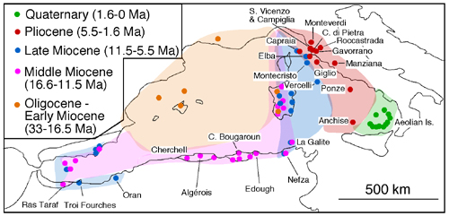
Map showing the distribution of volcanic rocks in the western Mediterranean.
Evidence for an Oligocene volcanic arc is found in southern France and Sardinia. In southern France, calc-alkaline magmas erupted between the Oligocene and the Middle Miocene (33-20 Ma)(Bellon 1981). Based on geochemical criteria, it has been suggested that volcanism took place in a north-dipping subduction system (Rehault et al. 1985). The volcanic arc continued southwestward in Sardinia and Valnecia Trough, although in the latter, volcanism commenced only at 25-24 Ma (Marti et al. 1992).
During the Lower – Middle Miocene, extension took place in the Ligurian Sea and Valencia Trough, and the volcanic arc migrated with accordance of the retreating slab. In Sardinia, ongoing volcanism occurred until 14 Ma (Savelli 1988). The largest amount of Middle Miocene volcanism is found in the North African coast and in the Alboran Sea (Lonergan & White 1997, El Bakkali et al. 1998, Maury et al. 2000, Zeck et al. 2000, Fourcade et al. 2001 and references therein). Calc-alkaline volcanism occurred in North Africa between 16.5-8 Ma, following the accretion of the Kabylies blocks to the African margin at ~18-15 Ma (Lonergan & White 1997). Volcanic activity in the Alboran Sea and the Betic-Rif cordillera has been dated to 15-7 Ma, and was probably associated with an east-dipping subduction zone that retreated westward towards Gibraltar during Middle-Late Miocene (Lonergan & White 1997).
Since the Late Miocene, the majority of volcanism in the western Mediterranean has been concentrated in the Tyrrhenian Sea (Savelli 1988, 2000, Serri et al. 1993, Argnani & Savelli 1999)(Figure 9). In this region, calc-alkaline volcanics become younger from west to east, and show a geochemical polarity that resulted from a west dipping subduction (Savelli 2000). The existence of magmas younger than ~7 Ma eastward of the Sardinia-Corsica axis suggests commencement of eastward slab rollback at 10-7 Ma. It can also be recognised that arc migration first occurred in the northern Tyrrhenian, and only later (~5 Ma) occurred in the southern Tyrrhenian. The youngest calc-alkaline volcanics, found in the Aeolian Islands, mark the present location of the volcanic arc associated with a Benioff Zone beneath Calabria.
Deep structures in the Mediterranean region have been studied from the analysis of seismic data, and particularly from seismic tomography images (Wortel & Spakman 1992, Spakman et al. 1993, Carminati et al. 1998, Wortel & Spakman 2000). Seismic tomography is based on the contrast between seismic velocities produced by the existence of relatively cold subducting lithosphere within the surrounding hot asthenosphere. It thus provides an insight to the three-dimensional structures of subduction systems long after the generation of earthquakes has ceased (Wortel & Spakman 1992).
Seismic tomography results strongly support the existence of subduction systems throughout the western Mediterranean. A well-defined Benioff Zone is found in the Calabrian Arc, where active subduction of the Ionian plate is taking place. It is associated with deep (>500 km) earthquakes (Anderson & Jackson 1987), and is clearly recognised in tomographic images that show a northwest dipping lithospheric slab subducting beneath Calabria, and flattened in the upper/lower mantle boundary (Lucente et al. 1999). In other localities, such as the Apennines and the Alboran Sea, the seismic tomography images show subducting slabs detached from the lithosphere at the surface (Wortel & Spakman 2000). Beneath the Apennines, a detached lithospheric slab is recognised at 150-670 km depth. It is dipping towards the southwest, and indicates the remnant subduction system that existed during the opening of the Tyrrhenian Sea (Lucente et al. 1999). In the Alboran Sea, a detached lithospheric slab at depths of more than 600 km has been deduced from deep seismicity and tomographic images (Buforn et al. 1991, Seber et al. 1996, Calvert et al. 2000). However, the tectonic significance of the detached slab has been ambiguously interpreted as evidence for east dipping subduction (Lonergan & White 1997), lithospheric delamination (Seber et al. 1996, Calvert et al. 2000), and a convective removal of thickened lithosphere (Platt & Vissers 1989). In the North African margin, tomographic anomalies have not been clearly recognised due to a relatively poor spatial resolution (Spakman et al. 1993). However, it has been suggested that existing anomalies below Algeria indicate remnants lithospheric mantle ruptured and segmented from the Tyrrhenian and the Alboran subduction systems (Carminati et al. 1998).