In this section, we briefly discuss the main characteristics of geological terranes that were incorporated in the post-Oligocene evolution of the western Mediterranean. Time relationships between the different terranes are presented in Figure 4.
Figure 4. Time-space diagram
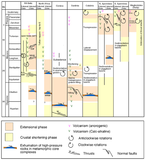
Time-space diagram of the tectonic activity in the western Mediterranean (time scale after Palmer 1983). Data compiled from Boccaletti et al. (1990), Oldow et al. (1990), van Dijk & Okkes (1991), Caby & Hammor (1992), Carmignani et al. (1994), Crespo-Blanc et al. (1994), Ferranti et al. (1996), Saadallah & Caby (1996), Azañon et al. (1997), Sowerbutts (2000) and Crespo-Blanc & Campos (2001).
The mountains of the Betic in southern Spain and the Rif in northern Morocco surround the Alboran Sea to form an arc shape orogenic belt in the westernmost Mediterranean (Figure 5). This belt marks the western terminus of the Alpine orogen. The rocks of the Rif-Betic cordillera are usually divided to three main zones: the Internal Zone, the External Zone and the Flysch Zone. The Internal Zone consists of allochthonous Paleozoic to Early Miocene rocks, which were thrust onto the External Zone during the Miocene (Crespo-Blanc et al. 1994, Crespo-Blanc & Campos 2001). Alpine deformation and metamorphism affected the Internal Zone during the Cretaceous and the Tertiary, and crustal rocks were buried to great depths and underwent high-pressure metamorphism (de Jong 1990). The External Zone consists of Mesozoic to Tertiary rocks, which represent the passive margin of Africa and Iberia deforming during Alpine orogeny. The Flysch Zone mainly consists of Early Cretaceous to Early Miocene deep marine clastic deposits (Wildi 1983).
Figure 5. Alboran Sea and the Rif-Betic cordillera
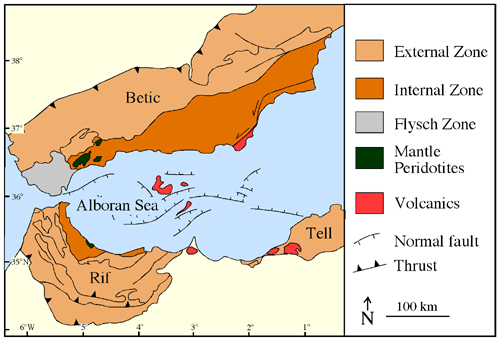
Geological map of the Alboran Sea and the Rif-Betic cordillera (after Platt & Vissers 1989).
Structural and metamorphic relationships in the Rif-Betic cordillera, particularly from the Internal Zone, show that several contractional and extensional episodes took place. The earliest extension was probably associated with rapid isothermal exhumation of the high-pressure rocks in the Late Oligocene – Early Miocene, and probably commenced at ~30 Ma (Azañón et al. 1997, Platt et al. 1998). Few authors have demonstrated that coeval with crustal shortening in the External Zone, earlier thrust faults in the Internal Zone were rejuvenated as extensional detachments (Azañón et al. 1997, Martínez-Martínez & Azañón 1997). Extension led to vertical thinning and isothermal exhumation of high-pressure rocks now exposed beneath low-angle normal faults (Platt et al. 1983, Azañón et al. 1997, Balanya et al. 1997). Furthermore, during the Early Neogene, a slab of diamond-bearing mantle peridotites was exhumed and juxtaposed amidst crustal rocks of the Internal Zone (Van der Val & Vissers 1993). Radiometric dating of the high-pressure rocks suggests a rapid exhumation during the Late Oligocene - Early Miocene (27-18 Ma) (Monie et al. 1994, Platt et al. 1998).
The floor of the Alboran Sea consists of rocks similar to those found in the Rif-Betic cordillera, and covered by Early Miocene syn-rift deposits and post-rift marine sediments (Comas et al. 1992, Platt et al. 1998). It is therefore evident that the region was subjected to widespread extension during the Middle Miocene that led to the formation of the Alboran Sea. However, contemporaneously with extension in the Alboran Sea, thin-skinned thrusting and folding took place in the External Zones of the Rif-Betic cordillera (Platt & Vissers 1989, Platzman et al. 1993, Crespo-Blanc & Campos 2001). This deformation was accompanied by a considerable amount of block rotations around vertical axes, with clockwise rotations in the Rif and counterclockwise rotations in the Betic (Allerton et al. 1993, Platzman et al. 1993, Lonergan & White 1997).
The mountain chain of the Maghrebides in Northern Africa and in Sicily consists of a stack of south-verging thrust sheets that bridges the Apennines of Italy with the Rif Mountains of Morocco (Figure 1). Most rocks exposed in the Maghrebides are non-metamorphic sedimentary units of Mesozoic to Early Miocene age deposited on the southern margin of the Tethys Ocean (Wildi 1983). The southern boundary of the Maghrebides is a low-angle thrust fault (the Tellian Front) that delimits the Maghrebides nappes from the autochthonous terranes of the Atlas chain (Wildi 1983). More internal zones of the orogen are found in northern Algeria and Tunisia (Grande and Petite Kabylies), as well as in a submerged fold-and-thrust belt between Sicily and Tunisia (Compagnoni et al. 1989, Tricart et al. 1994). These internal terranes originated in the Alpine orogen and were overthrust onto the Maghrebides during the opening of the western Mediterranean basins (Cohen 1980).
The Kabylies consist of a Hercynian basement and Mesozoic sediments, metamorphosed and strongly deformed during Alpine orogenesis. Alpine metamorphism took place during the Cretaceous and the Tertiary (Peucat & Bossière 1981, Monié et al. 1984; 1988; 1992, Cheilletz et al. 1999), and involved metamorphism at high-pressure conditions. High-pressure rocks are presently exposed in metamorphic core complexes, and are directly overlain by rocks that did not suffer Alpine metamorphism (Caby & Hammor 1992, Saadallah & Caby 1996). Their exhumation seems to be associated with horizontal extension accommodated along low-angle-normal faults (Caby & Hammor 1992, Saadallah & Caby 1996). Deformation along these faults is usually associated with flat lying foliations and mylonitic shear zones with top-to-the-NW sense of shear (Caby & Hammor 1992, Saadallah & Caby 1996). Radiometric dating indicates that extensional deformation probably occurred at 25-16 Ma (Moniéet al. 1984, 1988, 1992).
Thrusting in the External Maghrebides commenced at the Early/Middle Miocene and was generally directed southward and southeastward (Frizon de Lamotte et al. 2000 and references therein). Since the Tortonian, the locus of major crustal shortening has migrated southward until a ~400 km wide area was structured as a fold-and thrust belt (Tricart et al. 1994).
The islands of Corsica and Sardinia consist of a Hercynian basement and a Mesozoic-Tertiary cover which are overthrust (in northern Corsica) by slivers of Alpine origin (Mattauer et al. 1981)(Figure 6). The External Units probably originated in the southern margin of Europe, and are usually reconstructed to a position adjacent to southern France or northeast Spain (Figure 2). The separation of these terranes from Europe is attributed to the post-Oligocene rifting in the Gulf of Lion and the opening of the Ligurian Sea, in which the islands underwent ~30-° of counterclockwise rotations (Montigny et al. 1981).
Figure 6. Corsica and Sardinia
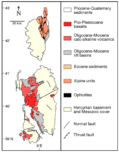
Geological map of Corsica and Sardinia after Cherchi and Montadert (1982) and Jolivet et al. (1990).
In the nappe stack of Alpine Corsica, high-pressure ophiolitic rocks and non-metamorphic rocks are overthrust on top of external (mainly granitic) units. Radiometric ages of the high-pressure rocks in Alpine Corsica indicate that metamorphism took place during the Late Cretaceous and Tertiary (Jolivet et al. 1998, Brunet et al. 2000 and references therein), at the same time when high-pressure metamorphism occurred in the western Alps. Structural evidence shows that Alpine Corsica was thrust over the Hercynian basement with a westward sense of movement and that these structures are overprinted by younger extensional structures with eastward sense of shear (Fournier et al. 1991). Extensional deformation occurred at greenschist-facies conditions and is defined in localised shear zones along extensional detachments (Fournier et al. 1991, Daniel et al. 1996). This style of extension led to isothermal exhumation of the metamorphic core complex now preserved in northeast Corsica (Jolivet et al. 1990, Fournier et al. 1991). An age of ~32 Ma has been estimated as the commencement of extensional deformation in Corsica (Brunet et al. 2000).
The island of Sardinia consists of a Hercynian basement and a Mesozoic to Eocene sedimentary cover, overlain by syn and post-rift sediments and volcanics (Cherchi & Montadert 1982)(Figure 6). The island is transected by a N-S striking rift that forms a succession of tilted blocks filled with Oligocene-Miocene continental to marine sediments (Cherchi & Montadert 1982). Rifting probably commenced in the middle Oligocene (~30 Ma), and at the end of the Oligocene the trough was deep enough to allow invasion by sea (Cherchi & Montadert 1982). The latest syn-rift sediments are Aquitanian in age, indicating that rifting ceased at 23-24 (Cherchi & Montadert 1982). A second phase of extension that postdated the formation of the Sardinian rift took place at mid-Aquitanian to early Burdigalian (23-20 Ma) (Sowerbutts 2000). Letouzey et al. (1982) have reported Burdigalian (21-17 Ma) NE-SW contractional structures, which seemed to occur simultaneously with a third extensional phase associated with the reactivation of N to NNW trending normal faults (Sowerbutts 2000).
Calabria is a nappe-structured belt in the southernmost part of the Italian Peninsula and the northeastern corner of Sicily connecting the Apennines and the Maghrebides (Figure 7). The northern and the southern boundaries of the Calabrian block are major strike-slip faults, the sinistral Sagiento Line and the dextral Taormina Line; their sense of motion indicates that the whole Calabrian block underwent eastern displacement relative to the Apennines and Maghrebides (van Dijk & Scheepers 1995). The rocks in Calabria are remarkably different from those in the Apennine-Maghrebide belts indicating prolonged tectono-metamorphic evolution associated with Alpine orogenesis.
Figure 7. Italian Peninsula and Sicily
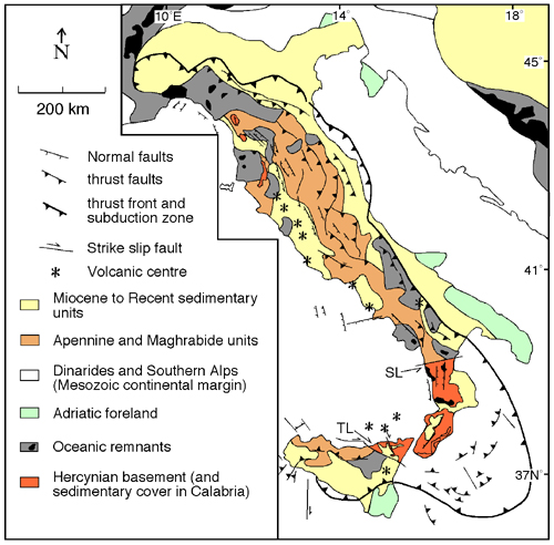
Geological map of the Italian Peninsula and Sicily, modified after Channell et al. (1979) and Patacca et al. (1993). SL = Sagiento Line; TR = Taormina Line.
The Calabrian nappes are divided into three major tectonic units (Amodio-Morelli et al. 1976). The lowermost unit consists of a Mesozoic carbonate platform that belongs to the margin of Adria. It is overlain by two ophiolitic nappes composed of Mesozoic and Cenozoic sedimentary and ophiolitic rocks partly metamorphosed under high-pressure conditions (Knott 1987, Cello et al. 1996). The uppermost unit consists of a Paleozoic Hercynian basement and a Mesozoic to Cenozoic sedimentary cover with a strong Alpine signature (Knott 1987). The latter allochthonous terrane, thereafter referred as the Calabrian block, was progressively empvVan Dijk & Okkes 1991).
The age of high-pressure metamorphism in the Calabrian block is ambiguous and varies between 60-35 Ma (Schenk 1980, Rosseti et al. 2001). During the Oligocene and the Miocene, isothermal exhumation of the high-pressure rocks took place (Rosseti et al. 2001). This led to the emplacement of weakly metamorphosed and nonmetamorphosed rocks on top of high-pressure rocks in tectonic contacts of low-angle extensional detachments (Platt & Compagnoni 1990, Rosseti et al. 2001). The commencement of extensional tectonics has been inferred as ~30 Ma from 40Ar/39Ar data (Rosseti et al. 2001).
The Apennine belt is a Late Cenozoic fold-and-thrust belt striking parallel to the Italian peninsula from Calabria to the western Alps (Figure 7). The nappes of the Apennines predominantly consist of non-metamorphic or weakly metamorphosed Late Triassic to Neogene marine sediments probably deposited on the passive margin of the Adriatic foreland. The autochthonous crystalline basement is rarely exposed and is only found in the area of Alpi Apuane tectonic windows (northern Apennines). In these outcrops, low-angle normal faults juxtaposed the allochthonous cover above a Hercynian basement, which was metamorphosed at high-pressure conditions at ~25 Ma (Carmignani & Kligfield 1990, Carmignani et al. 1994, Jolivet et al. 1998, Brunet et al. 2000). Extensional tectonics during the Oligocene-Miocene has been considered to play an important role in the exhumation of the Hercynian basement (Carmignani et al. 1994, Jolivet et al. 1998).
Deformation in the Apennines commenced in the Oligocene in the Northern Apennines (Boccaletti et al. 1990) and has propagated southward since the Late Miocene. During deformation, the front of the Apennine thrust system migrated eastward and is presently located predominantly in the Adriatic Sea (Jolivet et al. 1998, Brunet et al. 2000). While ongoing thrusting took place in the (eastern) external Apennines, the (western) internal domain was subjected to crustal extension (e.g. Carmignani et al. 1994, Ferranti et al. 1996) forming extensional sedimentary basins that become younger towards the east (Patacca et al. 1990).