The velocity field and its assessment
On the basis of geodetic observations, in order to infer the velocity field of the Aegean area and Anatolia region and their surroundings, two global solutions were used.
They were computed by the IERS (International Earth Rotation Service) in its institutional activity, based on permanent tracking sites (mainly GPS stations, but also SLR, VLBI, DORIS and recently GLONASS).
In fact, it is well known that reliable geodynamics information can be inferred on a geodetic basis only by permanent geodetic networks (Beutler, 1998). That also because the analysis of coordinate time series of permanent tracking highlights that spurious, long period oscillations, due to mismodelling and unknown site effects, they may be present and corrupt the geodynamical interpretation. Therefore they must be filtered out in advance (Langbein and Johnson, 1997; Mao et al., 1999).
The mentioned IERS global solutions provide the coordinates, velocities and RMS of each tracking site, obtained after the adjustment of a certain number of sub-network solutions analysed by local data centers, under the hypothesis of steady velocity for each site. The number of stations contributing to the global solution is annually updated. It is worthwhile to recall that, in the geodetic terminology, a set of points with their coordinates and velocities realizes a reference frame. The frames produced by IERS are named IERS Terrestrial Reference Frames (ITRF), they are referred to a precise epoch, as the coordinates change continuously in time (Boucher and Altamimi, 2001).
The two solutions (Figure 3 and Figure 4) considered in the present research are the most recent realizations of ITRF, ITRF97 and ITRF2000, both estimated at epoch 1997.0 (1997, Jan 1).
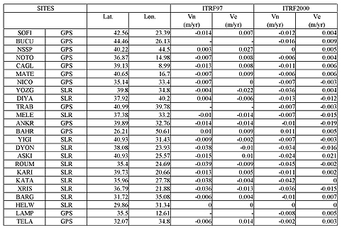
Concerning the Eastern Mediterranean and the Anatolian region, we analysed the ITRF97 and ITRF2000 solutions focusing our attention on a subset of GPS and SLR stations covering the area of our interest. We select 24 tracking stations (Table 1), 13 observed continuously by GPS (12) and SLR (1) and 11 by mobile SLR, sites considered less reliable than the permanent ones (Altamimi, pers. comm.).
We computed the northward and eastward components of velocity Vn, Ve (Table 1). We analyzed the 2D velocities (Figure 3 and Figure 4) with their azimuth for the selected sites with respect to HELW (Helwan, Egypt, African plate), starting from the Vx, Vy and Vz components listed in the ITRF97 and ITRF2000 solutions (http://lareg.ensg.ign.fr/ITRF/).