Geodynamic setting
Africa, Greece, Anatolia, Eurasia and Arabia: these are the plates involved in the geodynamic reconstructions of the eastern Mediterranean. Deformation is very active in the all area (Papazachos and Kiratzi, 1996; Bozkurt, 2001). The most prominent geodynamic factor in shaping the eastern Mediterranean is the northeast directed subduction of Africa underneath Greece and the Anatolia plate (Eurasia). Seismic lines across the Cyprus arc (Sage and Letouzey, 1990; Vidal et al., 2000), at the southern margin of the Anatolia plate, show clear active compression and deformation of the seafloor.
Figure 1. GPS velocity field
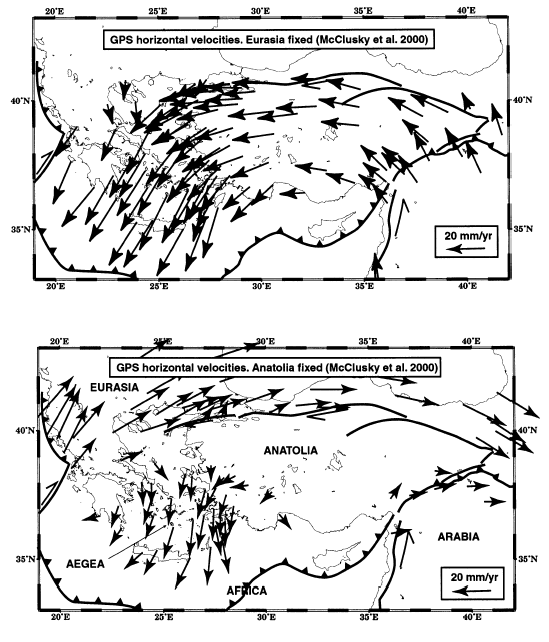
GPS velocity field after McClusky et al. (2000) relative to Eurasia (above) and to Anatolia (below). Note the increase in velocity moving westward which is not consistent neither with squeezing of the Anatolia due to the supposed indenter of Arabian, nor to a gravitational collapse. The velocity should rather decrease moving away from the energy source. See discussion in the text.
The Aegean Sea is generally considered as a backarc basin due to the aforementioned subduction (Le Pichon and Angelier, 1979). However, according to Makris (1978) and Makris et al. (2001), the Aegean Sea is characterized by a relatively thick crust (20-25 km), in spite of a long standing subduction, probably active at least since Cretaceous times (Meulenkamp et al., 1988). The subduction zone migrated southwestward, and the associated orogen was later replaced by the extension. In the Aegean Sea, Alpine crustal thickening with HP/LT were followed by non co-axial crustal-scale extension (Rosenbaum et al., 2002). This is coherent with first the emplacement of thrust-sheets of basement slices, later cross-cut by extensional or transtensional faults. Extension and associated magmatism also were and still are south-southwest migrating (e.g., Jackson and McKenzie, 1988), and they developed particularly since the Oligocene, while subduction began much earlier. "Normal" backarc basins (e.g., the Tyrrhenian Sea) associated with west-directed subduction zones open very fast (10-20 Myr) and they are always contemporaneous to the subduction. Moreover they are characterized by oceanization and eastward migration of extension and related magmatism, features directly surrounded by a frontal accretionary wedge. On the contrary, the accretionary wedge of the Hellenic subduction is the southeastern prolongation of the Dinaric thrust belt, where no back-arc rift comparable to the Tyrrhenian Sea occurs.
Figure 2. Present day plate motion vectors
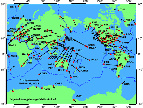
Present day plate motion vectors inferred from space geodesy, with reference to an hypothetical fixed Earth center (ITRF, International Terrestrial Reference Frame). After NASA data base, Heflin et al. 2001.8. Note the main northeastward direction of plates motion in the Mediterranean and in the adjoining plates (e.g., Arabia, India, Europe, Africa).
In spite of that, most geodetic analysis in the study area have been computed assuming the motion of the Aegean area and Anatolia relative to fixed Europe or sometimes to Turkey (e.g., Kahle et al., 1998, McClusky et al., 2000, Figure 1), rather than to fixed Africa. This was also related to the paucity of geodetic sites in northern Africa. However, since the main deformation occurs along the subducting plate margin of Africa underneath Eurasia, we tried to analyze the relative motion in this different reference frame.
Figure 3. ITRF97 velocity field
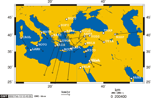
ITRF97 velocity field computed with respect to HELW (Egypt, African plate).
Figure 4. ITRF2000 velocity field
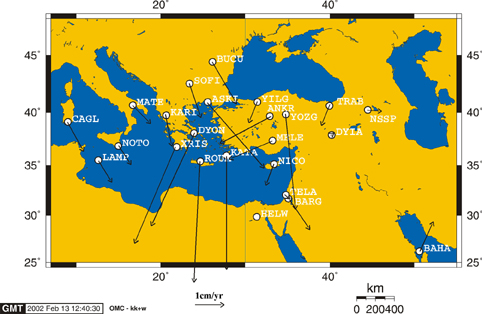
ITRF2000 velocity field computed with respect to HELW (Egypt, African plate).
In an “absolute” reference frame, the NASA data base on present global plate motions (Heflin et al., 2001, http://sideshow.jpl.nasa.gov:80/mbh/series.html) referred to the ITRF (International Terrestrial Reference Frame). It shows how the motions of Africa, Europe, Arabia and Anatolia plates are mainly NE directed (Figure 2). In particular the Arabia plate shows a direction of motion, which strongly deviates with respect to the N-S direction of the paradigm proposed in the dominant literature for the eastern Mediterranean geodynamics. A north-south component in the northwestern margin of the Arabia plate can be expected for left-lateral transpression component at the northwestern part of the Zagros belt. These data of mainly NE-SW direction have been shown to be consistent with directions of plates motion during the Neogene and Quaternary (Doglioni, 1990).
Figure 5. Eocene angular unconformity
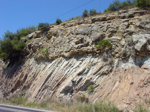
Angular unconformity between flat lying Eocene nummulitic shallow water limestone, resting on highly tilted and folded Cretaceous-Early Paleogene Scaglia facies. This documents pre-Eocene active compression in northern Turkey. North to the right. Road between Adapazari and Bileçik, 5 km north of Osmaneli (40° 26' N, 30° 02' E).
Figure 6. Miocene angular unconformity
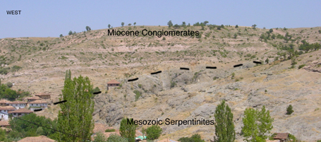
Angular unconformity between flat lying Miocene alluvial conglomerates onlapping and pinching out an erosional surface on the ophiolites, indicating pre-Miocene compression-related exhumation of the serpentinites, erosion, and later subsidence associated with extensional tectonics. Outcrop near Çamsu, northeast of Usak, north-western Turkey (38° 52' N, 29° 36' E).
In other words, we should rather analyze the eastern Mediterranean plate tectonics in terms of both absolute motions, and relative motions of Greece and Turkey relative to Africa. In fact, assuming Africa as a single plate, since Greece is overriding Africa along the Hellenic trench faster than Turkey along the Cyprus arc, it turns out that there is a positive velocity among Greece and Turkey in the hangingwall of the subduction zone. In fact, Greece is moving SW-ward above Africa faster than Turkey (Figure 3 and Figure 4), which implies extension between Greece and Turkey in the Aegean area and western Anatolia, without any relation in this circuit with the Arabia plate. According to this geodynamic interpretation, during the compressive events associated with northeast directed subduction (Figure 5), basement rocks (both continental and ophiolitic slices) in west Anatolia and the Aegean Sea were uplifted and eroded. Later extension subsided the area, and the basement slices were covered by continental and marine sediments (Figure 6). The extension in western Anatolia and Aegean area was, and still is, dominated by similar absolute framework of plate motion. The previous horizontal NE-SW direction of the sigma 1 in the compressive stage became the trend of the sigma 3 (Figure 7), implying NW-SE trending normal faults or grabens, about E-W-trending right-lateral transtensional faults, and N-S-trending left-lateral transtensional faults. The study area is cross-cut by a net of faults which follow this rule. See a field example of northwest Anatolia with left-lateral transtension in Figure 8.
Figure 7. Miocene-Quaternary faults
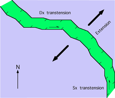
Main directions and tectonic meaning of Miocene-Quaternary faults in western Anatolia and Aegean.
Figure 8. Left lateral transtensive fault
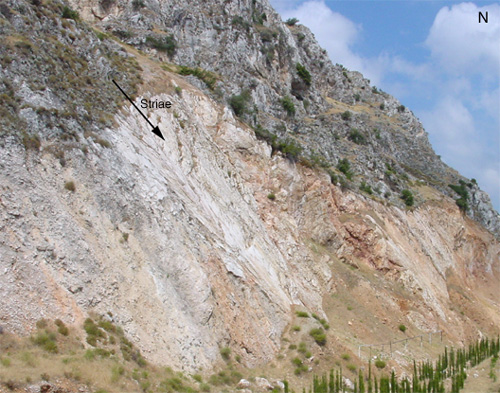
Field example, looking northward, of a N-S trending left lateral transtensive fault near Kirkagaç, 20 km NE of Akhisar (39° 06' N, 27° 42' E).