Introduction
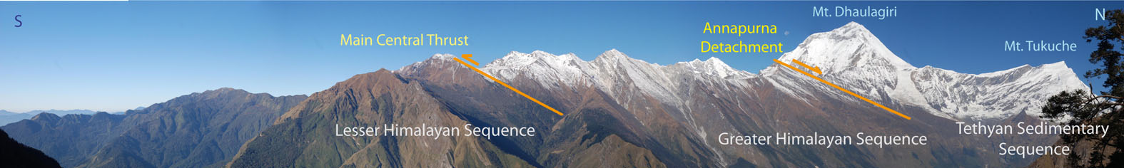
The Kali Gandaki valley, located in the Mustang-Myagdi region of central Nepal, is a deep north-south trending feature that cuts across the main Himalayan belt. The Kali Gandaki river cuts a gorge > 6000 m in deep in between some of the highest peaks of the Himalayan range, west of Mt. Manaslu (Figs. 1, 2), including Dhaulagiri (8167 m) to the west and Nilgiri (7003 m) and Annapurna (8091 m) to the east.
The valley cross-cuts the major tectono-stratigraphic units of the Central Himalayan belt (Fig. 1) affording an excellent opportunity for their examination (e. g. Colchen et al. 1986; Vannay and Hodges, 1996; Godin, 2003; Upreti and Yoshida, 2005; Larson and Godin, 2009) (Figs. 1, 2). These units include: (1) the Tethyan Sedimentary Sequence (TSS), an almost continuous 10 km-thick early Paleozoic to early Tertiary in age sedimentary succession (Bordet et al., 1981; Colchen et al., 1986; Garzanti 1999; Godin et al., 1999a,b; Godin, 2003; Kellett and Godin, 2009, Myrow et al., 2009), (2) the Greater Himalayan Sequence (GHS), the metamorphic core of the Himalayan orogen, a 20-30 km thick sequence of medium to high-grade metamorphic rocks intruded locally by Miocene leucogranites (Vannay and Hodges, 1996; Visonà and Lombardo, 2002; Larson and Godin, 2009; Visonà et al., 2012), which is separated from the overlying Tethyan Sedimentary Sequence by the South Tibetan Detachment (STD) (Godin, 2003) or Annapurna Detachment in the Kali Gandaki valley and, (3) the Lesser Himalaya Sequence (LHS), which consists of Precambrian to Mesozoic un-metamorphosed to low-grade metamorphic sediments, which is over-thrust by the Greater Himalayan sequence across the Main Central Thrust (MCT) (Le Fort, 1975).
Figure 1. Geological sketch map of the Himalayas
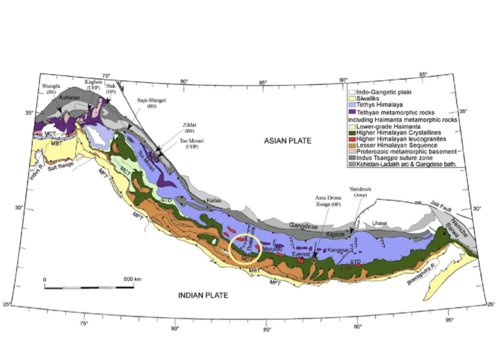
Geological sketch map of the Himalayas showing the main tectonic units and location of the Kali Gandaki valley and Thakkola graben. From S. Guillot, website
Figure 2. Panoramic view of the main tectonic units in the Kali Gandaki
North-South panoramic view of the main tectonic units in the Kali Gandaki valley from the Lesser Himalayan Sequence (South) to the Tethyan Sedimentary Sequence (North) through the Mt. Dhaulagiri and Mt. Tukuche. View is form East to West
This field trip describes an itinerary running from the TSS, through the GHS and ending in the LHS. Some of the stops described here partly correspond to the stops reported in field guidebook by Upreti and Yoshida (2005), a recent and comprehensive field guide book that describes several aspects of the geology and natural hazards of the Kali Gandaki valley.
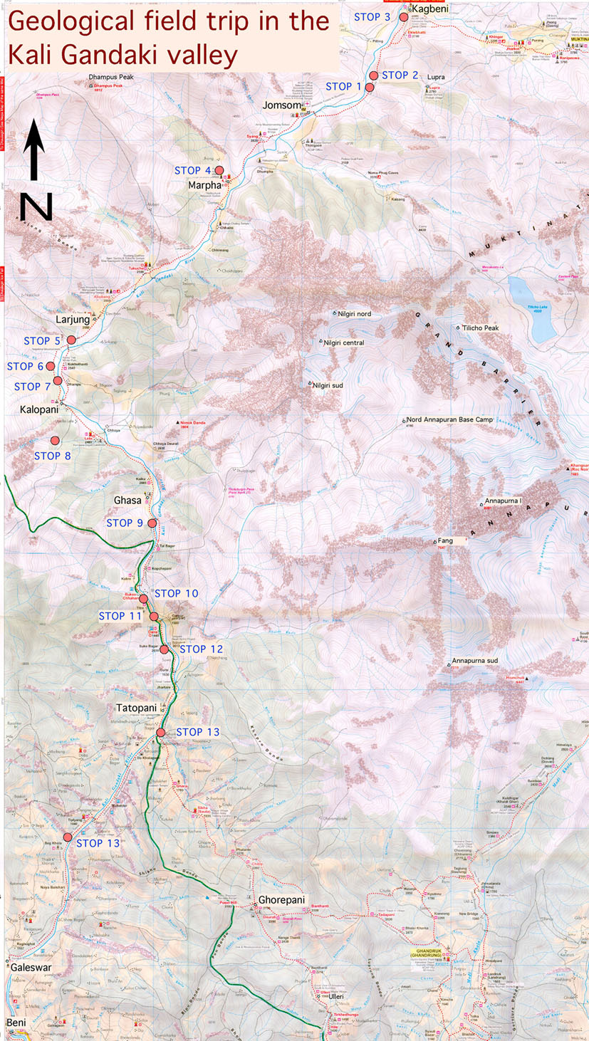
We approach to the geological stops (Fig. 3) in the same order as proposed by Upreti and Yoshida (2005). The starting point is the village of Jomsom (2720 m), which can be reached by either jeep or bus via the relatively new dirt road from Beni to Muktinath, or by a small aircraft from Pokhara airport. From Jomsom we suggest to first travel to the north to Muktinath (3700 m) through the Tethyan Sedimentary Sequence and then follow the valley back down to the south through the Greater Himalayan Sequence and finally Lesser Himalayan Sequence to Beni in the lowermost part of the valley (Fig. 3). From Beni it is possible to catch a bus to Pokhara and from here to reach Kathmandu by either land or air.
Figure 3. The stops in the Kali Gandaki Valley
Localization of the stops in the Kali Gandaki Valley (topographic base modified from NepaMaps)
For background information relevant to the trip the main tectonic units are briefly described hereafter from the top to the bottom.
We describe the deformation structures in the units using the classical structural nomenclature indicating for example foliations as S1, S2 and so on. Each unit, however, records unique tectonic and metamorphic histories and as such the foliations, folds and structural elements cannot be correlated across them even if they are indicated by the same letters and numbers; S1, L1 etc. for the TSS does not correspond to similarly labeled structures in the GHS or LHS.