The Itineraray
From the Yarkand valley to the Aghil Pass
The motorable road (4WD needed) follows the Yarkand valley downstream from the town of Mazar (3780 m) towards west. East of Bazar Dara, the Mazar Granite is well exposed along the road cuts. Here the prevailing lithology is an altered granodiorite with peculiar biotite replaced by chlorite and calcic plagioclase cores replaced by sericite. The trek starts from the village of Ilik (3480 m) where Bactrian camels are usually hired.
Day 1. (Ilik – Sughet; 5-6 hours)
The path is quite flat and follows upstream the right banks of the Aghil Dara river. Few easy fords are necessary to cross the lateral streams. About 5 km from Ilik there is the first nice view towards SE of the junction with the Surukwat (Zug Shaksgam) river (Fig. 4a); a number of different geologic units are evident and dip to the south (right hand side in the landscape) and are, from left to right, the Bazar Dara Slates, the Red Sandstones with evident light-colored anhydride horizons, and the Metamorphites of the Surukwat Complex. The first good outcrop of the Bazar Dara Slates (N36°22’28,4’’ E76°40’54,4’’) shows pervasive slaty foliation overprinted by a well developed crenulation cleavage; deformed boudinaged quartz + carbonate veins are locally abundant and parallel to the regional foliation (Fig. 9a) steeply dipping towards north. Locally, the veins are folded and asymmetric folds suggest a compressional regime. The microstructure (Fig. 9b) of these two-micas quartzarenite shows biotite (XMg=0.55-0.70; AlVI=0.15-0.25), white mica (Si=3.10-3.25 a.p.f.u. on the basis of 11 oxygens) and minor chlorite (ripidolite: XMg=0.50-0.55) (Fig. 5) defining the regional slaty foliation Sm. A later, mm spaced, planar foliation (Sm+1) results from the crenulationof the Sm; this Sm+1 foliation is only locally evident and is defined by white mica as well as by the alignment of ilmenite (Fig. 9b). An older foliation mainly defined by white mica ± chlorite is preserved within microlithons and suggest a complex metamorphic evolution up to the upper greenschist facies. Moving southward along the path, the Bazar Dara Slates contain significantly larger flakes of white mica and are devoid of biotite, plus minor epidote-clinozoisite.
The path crosses huge alluvial fans hampering an easy reach of the outcrops (Fig. 9d,e). Further upstream, slivers of red sandstones and anhydrites crop out along the path. Laminated red slates, steeply dipping towards NNE, are crosscut by late discordant carbonate veins. The summer settlement of Sughet Ilich (N36°18’24,9’’ E76°35’59,9’’ – 3780 m) is a good place for camping. Here a small lateral valley is easy to explore and shows good outcrops of metagraywacke (Fig. 9c) and slate, rich in fine-grained chorite and white mica, locally crosscut by late cataclastic shear zones and by late discordant metamorphic quartz veins.
Figure 9. Bazar Dara Slates and Surukwat Complex
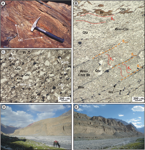
A) Bazar Dara Slates, lower Aghil Dara valley. Deformed quartz + carbonate veins (QC) are locally abundant and parallel to the regional foliation. B) Bazar Dara Slates: two-micas quartzarenite (Sample 01, lower Aghil Dara valley). Biotite (Bt), white mica (Wm) and minor chlorite (Chl) define the regional slaty foliation (Sm), which is crenulated with the local development of a Sm+1 foliation defined by Wm and Ilm. Plane Polarised Light (PPL). C) Surukwat Complex: red sandstone rich in detritic white mica and chlorite (Sample 06, lower Aghil Dara valley) cropping out at the lowermost structural levels of the Surukwat Complex, PPL. (D, E) Along the path toward Sughet, huge alluvial fans on the right side of the Aghil Dara valley hamper an easy reach of the outcrops.
Day 2. (Sughet – Chokor Itik; 6-7 hours)
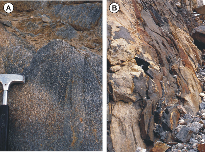
The first stage follows the river banks upstream of the middle Aghil Dara valley and a number of fords are necessary to see the outcrops. About 2 km upstream (N36°17’54,8’’ E76°35’22,8’’ – 3830 m), the lower structural levels of the Surukwat Complex are well exposed. A nice sequence of strongly deformed metabasites of dioritic to granodioritic composition with sub-vertical attitude, alternate with granodioritic to aplitic layers (Fig. 10a). Very low grade epidote + pumpellyte metamorphic veins are locally abundant and parallel to the regional foliation. The mineralogy comprises various amounts of feldspar, epidote, quartz, chlorite, amphibole, white mica and green biotite. The microstructure (Fig. 10b,c,d) shows a pervasive mylonitic to cataclastic fabric with peculiar sharply zoned amphibole porphyroclasts, with a yellow-pale green relic core (hornblende to edenite; Si=6.6-7.1 a.p.f.u., AlVI=1.1-1.4 a.p.f.u., AlVI=0.2-0.5 a.p.f.u., XMg=0.55-0.70) and a deep green rim (actinolite; Si=7.5-7.8, AlIV=0.2-0.6 a.p.f.u., AlVI=0.0-0.15 a.p.f.u., XMg=0.65-0.8) associated with epidote and wrapped by a crenulated foliation mainly defined by white mica (Si=3.30-3.40 a.p.f.u.), quartz and albitic plagioclase (Ab98-100) (Fig. 5).
Figure 10. Surukwat Complex
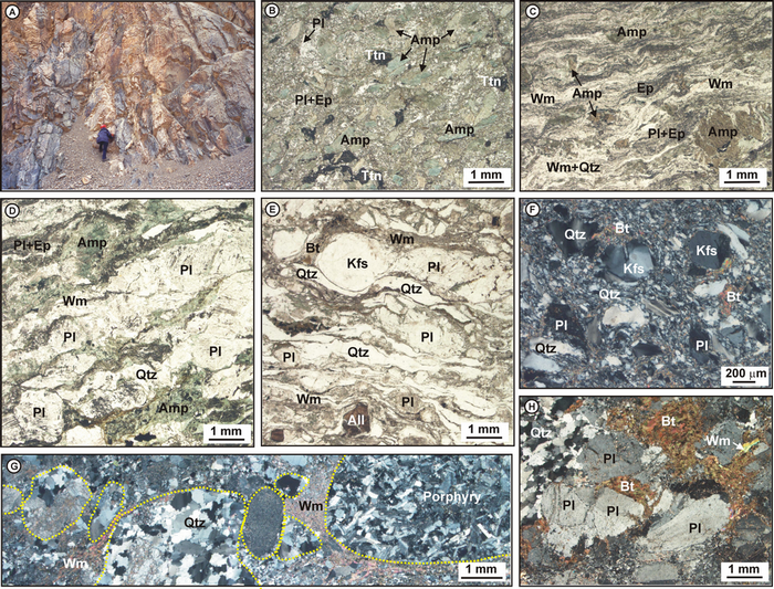
A) Surukwat Complex, middle Aghil Dara valley (S of Sughet Ilich). Strongly deformed metabasites of dioritic composition alternate with granodioritic to aplitic layers. B) Porphyritic metabasite (Sample 17, lower-middle Aghil Dara Valley). Amphibole (Amp) porphyroblasts are zoned, with a relic core and a green rim associated with epidote ± biotite in a matrix of albitic plagioclase (Pl) + epidote (Ep) ± biotite ± chlorite ± titanite (Ttn). PPL. C) Mylonitic metabasite (Sample 10, lower-middle Aghil Dara valley). Amphibole porphyroclasts are clearly zoned, with a yellow-pale green relic core and a deep green rim associated with epidote and wrapped by a crenulated foliation mainly defined by white mica (Wm), quartz (Qtz) and albitic plagioclase (Pl). PPL. D) Mylonitic metabasite (Sample 09, lower-middle Aghil Dara valley). Amphibole and plagioclase porphyroclasts are wrapped by a foliation defined by white mica (Wm), quartz (Qtz) and albitic plagioclase (Pl). PPL. E) Mylonitic orthogneiss with porphyroclasts of plagioclase (Pl), K-feldspar (Kfs) and allanite (All), wrapped by a foliation defined by stretched quartz, white mica and minor biotite (Bt) (Sample 22, middle Aghil Dara valley). PPL. F) Cataclastic Bt-bearing granitoid associated to metabasite (Sample 15, lower-middle Aghil Dara valley). Crossed Polarized Light (XPL). G) Polymittic metaconglomerate: the former pebbles of the protolith are several mm in size and include biotite-plagioclase bearing porphyric volcanic rock, as well as a number of different metamorphic lithologies (Sample 23, middle Aghil Dara valley). XPL. H) Weakly deformed Bt-bearing granitoid; magmatic biotite and quartz are recrystallised and white mica neoblasts are present (Sample 25, middle Aghil Dara valley). XPL.
After a small bridge the path follows a series of ups and downs along the right flank of the valley and a number of good outcrops are found. A body about 200 m thick of brecciated granitoid, rich in neoblastic white mica, is in contact with the previous lithologies; the contact is cataclastic (N36°17’33,0’’ E76°34’58,2’’ – 3870 m) (Fig. 10f). When less deformed, the porphyritic metabasite show a peculiar microstructure with amphibole porphyroclasts clearly zoned, with a relic core and a green rim associated with epidote ± biotite in a matrix of albitic plagioclase + epidote ± biotite ± chlorite ± titanite (Fig. 10b).
The path climbs a steep shoulder of the valley, where a km-thick shear zone is steeply dipping towards SSW and affects the same lithologies plus carbonate rocks, substantially devoid of metamorphism, with peculiar reddish weathering patinae. The strain regime varies locally from chiefly mylonitic to cataclastic. On the river banks, the shear zone includes also quartz – plagioclase – K-feldspar – biotite – epidote – tourmaline – allanite orthogneiss (Fig. 10e) associated with concordant layers of granitoids (N36°17’10,3’’ E76°34’59,7’’ – 3900 m).
The river is then forded twice; back on the left flank of the Aghil Dara valley, peculiar polymittic metaconglomerate horizons steeply dip towards S (N36°16’26,1’’ E76°34’24,4’’ – 3955 m). The former pebbles of the protolith are less than 1 cm in size and include biotite-plagioclase bearing porphyric volcanic rock, as well as a number of different metamorphic lithologies (Fig. 10g). Neoblastic biotite and epidote are widespread, as well as very fine-grained white mica and chlorite in the matrix.
Granitoids relative abundance increases, and a several hundred meters thick concordant intrusive body is apparent in the valley eastern ridge. The granitoid is weakly deformed; magmatic biotite and quartz are commonly recrystallised and white mica neoblasts are widespread (Fig. 10h). Here the valley turns southward and its floor becomes wide flat towards a main junction with two main valleys leading to W and SW respectively.
The eastern flank of the Aghil Dara valley shows a spectacular geologic cross section (Fig. 11), several hundred meters across, its regional foliation steeply dipping towards S (N36°15’39,7’’ E76°34’15,0’’ – about 4150 m). Here the Surukwat Complex shows its higher metamorphic grade and comprises schist with various amounts of quartz-plagioclase-carbonate-biotite-white mica-garnet-amphibole and late epidote-chlorite, impure quartzite with similar mineralogy, impure marble with biotite and quartz, amphibole-biotite-plagioclase-chlorite bearing metabasite (Fig. 12). Two metapelitic samples have been studied in detail by Groppo & Rolfo (2008) in order to unravel their metamorphic evolution. Metapelite 117 (Figs. 5, 12d,e) is a crenulated graphite (Gr)-bearing micaschist mainly consisting of white mica (Wm), chlorite (Chl), porphyroclastic garnet (Grt), ilmenite (Ilm) and minor biotite (Bt). The main foliation (Sm), defined by the preferred orientation of Wm, Chl and Gr flakes, derives from the strong transposition of an older schistosity (Sm-1), still preserved in crenulated microlithons and consisting of Wm, Chl, Bt and Ilm. Grt porphyroclasts are wrapped around by the Sm and are sharply zoned (core: Alm60-65Prp4-7Grs6-8Sps24-36, rim: Alm65-78Prp7-12Grs6-8Sps6-24), with a Gr-free core and a Gr-bearing rim. Aggregates of Wm ± plagioclase (Pl) and Bt pseudomorphically replace a former Al-bearing mineral (most likely staurolite), which is not preserved in the rock. Wm (Si=3.0-3.10 a.p.f.u.) and Chl (ripidolite: XMg=0.45-0.45) occur in different microstructural positions, defining the Sm-1, the Sm and as late flakes statically over-grown across the Sm. Metapelite 115 (Figs. 5, 12f) is a two-micas micaschist consisting of Qtz, Bt, Wm, Grt and minor Pl, Chl and Ilm. Porphyroblastic Grt (core: Alm71-75Prp7-9Grs2-3Sps12-15, rim: Alm69-71Prp6-7Grs2-3Sps20-21) is wrapped around by the main foliation (Sm) defined by the preferred orientation of Bt, Wm (Si=3.0-3.3 a.p.f.u.) and minor Ilm, and includes a Si (Sm-1) consisting of Qtz and minor Bt, Wm and Ilm. The Sm-1 foliation is also preserved in microlithons. Bt and Wm occur in both Sm-1 and Sm. Chl flakes (ripidolite: XMg=0.45-0.47) statically overgrow the Sm. On the basis of microstructural relationships and minerochemical data, three main assemblages have been recognised in the studied metapelites as summarized in Fig. 12g,h: i) a prograde assemblage; ii) a peak assemblage, and iii) a retrograde assemblage.
Figure 11. Geologic cross-section of the uppermost structural level of the Surukwat Complex
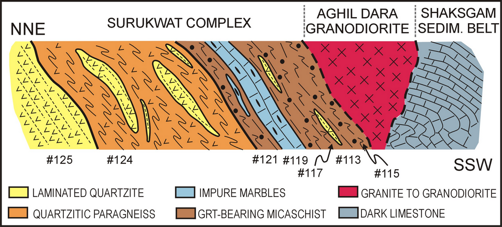
Schematic geologic cross-section of the uppermost structural level of the Surukwat Complex and its contact with the Aghil Dara Granodiorite and the Shaksgam Sedimentary Belt (not to scale), as inferred in the middle-upper Aghil Dara valley. Approximate location of studied metapelite samples is also given.
Figure 12. The Surukwat Complex
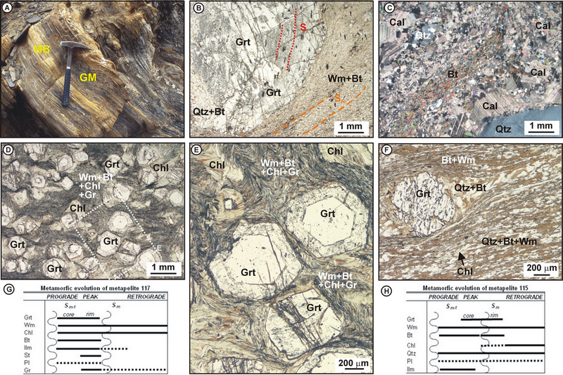
A) Surukwat Complex, middle-upper Aghil Dara (north of Chokor Itik). Impure marbles (MB) interbedded with graphitic micaschists (GM), locally rich in garnet. B) Garnet micaschist (Sample 113, middle Aghil Dara Valley). The fine-grained foliation (Sm) is defined by plagioclase, biotite, minor quartz and white mica, and is wrapped around centimetric garnet porphyroblasts. An internal schistosity (Si) is defined by ilmenite + quartz, and its absence mimic a former idioblastic mineral, possibly staurolite replaced by garnet. PPL. C) Biotite (Bt)- and quartz (Qtz)- bearing impure marble (Sample 119, middle Aghil Dara Valley). XPL. D) Garnet micaschist (Sample 117, middle Aghil Dara Valley). Grt porphyroblasts are wrapped around by the main foliation (Sm) defined by white mica (Wm), chlorite (Chl), and graphite and derived from the transposition of an older schistosity (Sm-1), still preserved in crenulated microlithons and consisting of Wm, Chl, Bt and Ilm. PPL. E) Detail of (D) showing the sharply zoned Grt porphyroclasts characterized by a graphite-free core and a graphite-bearing rim. PPL. F) Two-micas garnet micaschist (Sample 115, middle Aghil Dara Valley). Grt porphyroblast preserving a Si wrapped around by the Sm defined by Bt and Wm. Chlorite flakes statically overgrow the Sm. PPL. G, H) Metamorphic evolution of samples 117 and 115 studied by Groppo & Rolfo (2008).
Shortly after another turn of the Aghil Dara valley towards SE, look for a bridge to cross (otherwise the river may be not easy to ford) and reach the summer settlement of Chokor Itik which is a good place for camping (N36°14’00,4’’ E76°34’30,3’’ – 4330 m). Loose blocks of the Aghil Dara Granodiorite detached from the ridge overhanging the camp are locally abundant and also comprise peculiar porphyritic granitic varieties.
Day 3. (Chokor Itik – Durbin Jangal)
About 2 hours and 450 m of difference in level along an easy track and the Aghil Pass huge saddle is reached. The highest point and the real Pass is actually a little further to the SE beyond the lake (N36°10’57,8’’ E76°37’14,9’’ – 4815 m) (Fig. 13a). At the end of the small plain at 4000 m altitude, before the track runs southeast to the Aghil Pass, the tectonic boundary between the Aghil Dara Granodiorite and the Skaksgam Sedimentary Belt is crossed (Fig. 13b, c). The track along the northern side of the Aghil Pass mostly follows this contact, which has been already sketched by Auden (1938) and Desio (1980). The fault is characterized by decametre thick cataclasites, and is vertical to steeply dipping to the north. The wide Aghil Pass is open at around 4800 m and a small lake lies just before the flat watershed (Fig. 13a).
Figure 13. The Aghil Pass
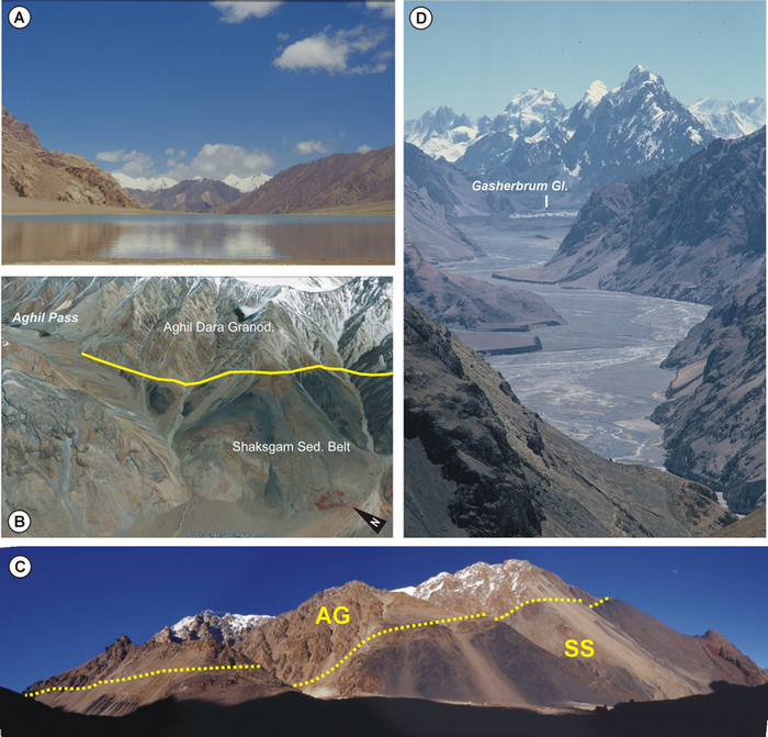
A) The lakelet before the cairn at the Aghil Pass. B) The Aghil Dara Granodiorite is thrusted on the Shaksgam Sedimentary Belt. From Google Earth images. C) Tectonic contact between the Aghil Dara Granodiorite (AG) and the black shales of the Shaksgam Sedimentary Belt (SS) from the Aghil Pass (view looking SE). D) From the southern side of the Aghil Pass, the sight runs till the Gasherbrum Glacier almost damming the valley of the braided Shaksgam river, some 20 km ahead.
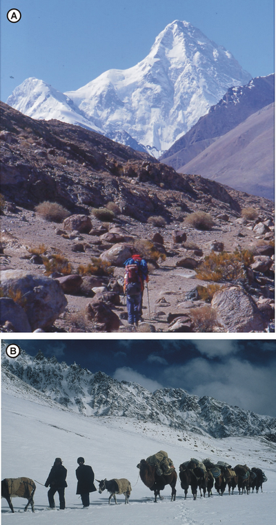
Southeast of the Aghil Pass, the granodiorite is thrusted over the sedimentary series (Fig. 13b). This fault coincides with the significant change in density occurring at this level, evident in the gravimetic profile 2 (Palmieri in Desio et al., 1991: pag. 64). From the pass the sight of the braided Shaksgam river and of the Karakorum Range is more and more open and imposing (Fig. 13c). The Aghil Dara Granodiorite mostly outcrops on the eastern side of the pass (Gaetani et al., 1990; 1991). Starting the descent towards the Shaksgam valley, tightly folded black slates and carbonates of probable Permian age occur. After having found the passage down the terrace of alluvial sediments of the valley, towards Durbin Jangal, the Jurassic red shales of the Marpo Fm. may be observed on the left hand side. About 3-4 hours upstream along the right banks of the Shaksgam river, with its mildly warm springs Durbin Jangal (N36°04’03,8’’ E76°40’09,8’’ – 4050 m) (Fig. 14a) is named after the binocular (“durbin” in Hindustani) forgotten by Younghusband in 1887. This is the only spot up in the valley, where some fodder may be found for the Bactrian camels that eat the leaves of bush trees.
Figure 14. The Shaksgam river
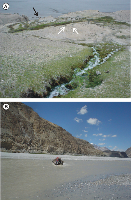
A) The mildly warm springs of Durbin Jangal, on the right banks of the Shaksgam river. The arrows point to the camp (black) and to camels (white), emphasizing the impressive size of the alluvial fan. B) Fording the Shaksgam river may be a dangerous task, especially in July and August when the glaciers melting is at its maximum and the waters are rugged.
From Durbin Jangal two itineraries are possible: 1) Towards the head of the Shaksgam valley. 2) Towards Sughet Jangal and the Sarpo Laggo Glacier.
Fording the Shaksgam river may be a dangerous task (Fig. 14b), especially in July and August when the glaciers melting is at its maximum and the waters are rugged.
Towards the head of the Shaksgam valley
The trekking towards the upper valley may last not less than three days upstream, as well as for the return. The legs are of about 6 hours of walking each day, without significant difference in level starting from about 4000 m a.s.l. They are: Durbin Jangal – Gasherbrum Glacier; Gasherbrum Glacier - Staghar Glacier; Staghar Glacier- Singhiè Glacier. No fodder for camels may be found.
Day 1
Easy walking along the pebbly flat of the valley, with at least one crossing of the river. A possible crossing point is after the Gasherbrum Cairn, but it depends on conditions where to ford. Pay attention to quick-sands ponds.
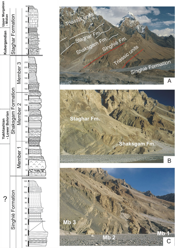
Most of the banks are made of the ancient terraces of fluvial conglomerate, that may form walls up to several tens of meters high. When the subsurface rocks crop out, they belong to the Permo-Triassic succession. The first interesting section may be observed around the small ridge dividing the lateral right affluent Bya and the Shaksgam valley, on the northern side of the valley (Figs 3, 15). In the upper part of the section, species belonging to the genera Leeina, Chalaroschwagerina, and Pseudoendothyra were identified, suggesting a Bolorian (≈ Kungurian) age, i.e. the upper part of the Lower Permian (Gaetani and Leven, in press). Another interesting Permian section may be observed around the mouth of the creek from the Skyang Glacier (N35°58’37”78; E76°42’15”47). It is better to cross the river upwards the section, to avoid steep rocks forming the bank of the river. Even if partially tectonically disrupted, the outcrop consists of layers of the Permian succession, mostly of the upper part of the Shaksgam Fm. and the Staghar Fm. Beds rich in fusulinids may be sampled. From this spot, walking another couple of hours will lead to the site for the camp.
Figure 15. The Shaksgam Fm
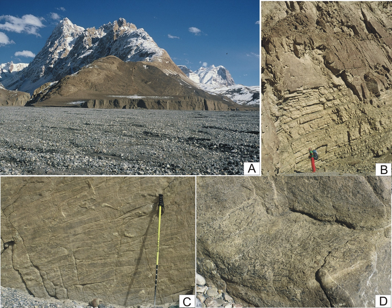
A) The ridge between Bya and Shaksgam. B) The sandstones at the top of member 2 of the Shaksgam Fm. G. Gosso as scale. C) Cross bedding in the sandstones of the member 2 of Shasgam Fm. D) Big fusulinids crowding the rock at the top of the member 2.
The camp may be put near the left moraine of the Gasherbrum Glacier though not very near to the river, to avoid danger by sudden flooding. In front of the camp is evident the Permo-Triassic succession, thrusted on the succession described in the next leg (see also the picture by Desio, 1980, pl. XV, fig. 1).
Day 2
The snout of the Gasherbrum Glacier may be contoured fairly easily, paying some attention only towards the end, where you have to pass on the bank of the river, with the ice hanging over your head.
This day may have two goals. The Karakorum Fault and the Urdok Doors stratigraphic sections. To have a look to the Karakorum Fault, walk up to the hillock between Gasherbrum and Urdok glaciers (Fig. 16a). This hillock is nicknamed “Monte Bianco” (Mont Blanc) because its altitude is 4810 m a.s.l., like the highest peak in the Alps. When reaching this cliff, you cross at length the lower part of the Permian succession, consisting of black slates of the lower member of the Singhiè Fm. The slates are crossed by numerous lamprophyric/potassic volcanic dykes (Fig. 18a) (Pognante, 1990). Further on, lenses of cherty limestone and dolostone, often cataclastic, form the hillock. A little ahead on the ridge you cross a major fault plane belonging to the Karakorum Fault system, which is better observed in front, on the left side of the Gasherbrum Glacier. The ridge offers a good general view of the Shaksgam Sedimentary Belt, the Karakorum Fault system, and the K2 metamorphics (Fig. 16; compare also with fig. 4.6 of Gaetani et al., 1991). Walking few kilometers up along the central moraine of the Gasherbrum Glacier will provide a nice view of the so-called Shaksgam Dolomites, built by the massive limestone and dolostone of the Aghil Fm., Triassic in age (Fig. 17a). The Gasherbrum Glacier is outstanding also from a morphological viewpoint, with its huge pinnacles (Fig. 16c, 17b, c).
Figure 16. The Monte Bianco hillock and the Gasherbrum Glacier
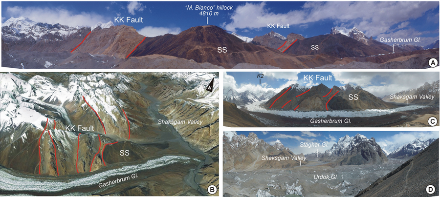
A) The “Monte Bianco” hillock (4810 m) from the Urdok glacier. The lower part of the Permian succession of the Shaksgam Sedimentary Belt (SS), consisting of black slates of the lower member of the Singhiè Fm is exposed on the hillock. A little ahead on the ridge a major fault plane belonging to the Karakorum Fault system (KK Fault) is encountered, that may be also observed in front, on the left side of the Gasherbrum Glacier. B) The west side of the Gasherbrum Glacier. From the right, the basal slate of the Singhiè Fm., a number of sedimentary slices including some cherty limestone and dolostone severely deformed by the Karakorum Fault system, and the black slates possibly belonging to the Wakhan Slates of the Northern Karakorum (From Google Earth). C) Panoramic view of the Gasherbrum Glacier from the “Monte Bianco” hillock (view looking NW). This ridge offers a good general view of the Shaksgam Sedimentary Belt (SS), the Karakorum Fault system (KK Fault), and the K2 metamorphics. D) Panoramic view of the Urdok Glacier and of the upper Shaksgam Valley from the “Monte Bianco” hillock (view looking SE).
Figure 17. The Shaksgam Dolomites, the Gasherbrum pinnacles and the K2 pyramid
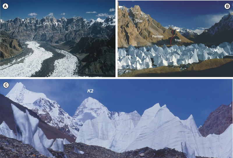
A) The “Shaksgam Dolomites”. They looks more imposing because two thrust sheets are superimposed; however, because of the perspective they seem in stratigraphical order. B) The “Gasherbrum pinnacles” as seen from the left side of the glacier. The pinnacles are the remnants of the ice stream in which the crevasses have been enlarged, partly due to melting, but mostly because of ice sublimation, due to the exceptionally dry climate. C) The impressive pyramid of K2 emerges from the pinnacles of the Gasherbrum glacier.
Besides the lamprophyric dykes crosscutting the black slates of the Singhiè Fm that may be observed in outcrop at the base of the Monte Bianco hillock (Fig. 18a), abundant lamprophyres occur in the moraines of the Gasherbrum and Urdok glaciers (Fig. 18b,c). Most of them may be classified as porphyritic minette, with phenocrystals of phlogopite and minor augite. The groundmass mainly consists of K-feldspar, ± phlogopite, ± clinopyroxene (augite and/or aegirine), ± amphibole, ± plagioclase. The mafic phenocrysts are locally hydrothermally altered to chlorite + carbonate, while the feldspars and the matrix are replaced by sericite or saussurite and carbonate. These lamprophyric dykes contain abundant xenocrysts of garnet, olivine (replaced by a fine aggregate of talc and magnetite) and brown spinel (Fig. 18d, e, f); the xenocrysts are systematically surrounded by a composite reaction rim consisting of phlogopite, ± magnetite, ± hornblende, locally with a kelyphitic microstructure. The most intriguing aspect of the lamprophyric dykes occurring in the moraines of the Gasherbrum and Urdok glaciers, however, is the presence of abundant deep crustal xenoliths (Fig. 18b,c) that can provide direct information on the nature and composition of the deep crust beneath the Northern Karakorum terrane, sampled by the lamprophyres on their way up to the surface. The xenoliths comprise mafic to ultramafic rocks and metasedimentary rocks. The mafic to ultramafic xenoliths include biotite + apatite -bearing clinopyroxenite (Fig. 18g) and garnet + clinopyroxene + plagioclase granulite (Fig. 18h). The metasedimentary samples are dominated by garnet + quartz + K-feldspar + plagioclase ± kyanite ± biotite granulite (Fig. 18i). Similar xenoliths associations included in ultrapotassic volcanic dykes have been reported from Pamir (Ducea et al., 2003; Hacker et al., 2005) and Tibet (Hacker et al., 2000; Chan et al., 2009), thus suggesting a similar first-order crustal structure for the Northern Karakorum, Pamir and Tibet (e.g. Searle et al., 2011).
Figure 18. Potassic volcanic dyke crosscutting the black slates of the Singhiè Fm
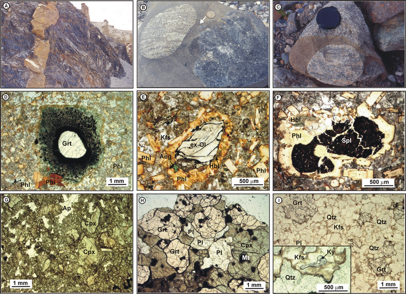
A) Potassic volcanic dyke crosscutting the black slates of the Singhiè Fm at the base of the “Monte Bianco” hillock. Hammer for scale. B, C) Deep crustal xenoliths enclosed in lamprophyric dykes (Gasherbrum moraine). The arrow in (B) points to a garnet xenocryst surrounded by a keliphitic rim. D, E, F) Xenocrysts of garnet (Grt: D), olivine (replaced by a fine aggregate of talc and magnetite) (ex-Ol: E) and brown spinel (Spl: F) occurring in phlogopite (Phl) –phyric minette. The xenocrysts are surrounded by a composite reaction rim consisting of phlogopite, ± magnetite, ± hornblende (Hbl), locally with a kelyphitic microstructure. Sample 44. PPL. G) Biotite + apatite -bearing clinopyroxenite xenolith hosted in a lamprophiric dyke. The spongy appearance of the clinopyroxene rim is due to the thermometamorphic effect induced by the dyke. Sample 54. PPL. H) Garnet + clinopyroxene + plagioclase granulite xenolith hosted in a lamprophiric dyke. Sample 91. PPL. I) Garnet + quartz + K-feldspar + plagioclase + kyanite granulite xenolith hosted in a lamprophiric dyke. The inset highlight a kyanite (Ky) crystal included in K-feldspar (Kfs). The dusty appearance of feldspar at their grain boundaries is due to the thermometamorphic effect induced by the dyke. Sample 45. PPL.
To study the Permian sections of Urdok Doors it is necessary to cross the river; in September 1988 it was easier to cross after the Urdok Glacier, passing on the glacier snout itself, here covered by debris. Two sections can be studied: downstream, even if some minor faults affect it, most of the Permian succession is exposed (Figs. 3, 19). Details of this section may be found in Gaetani and Leven (in press). Upstream, the slates of the Singhiè Fm. are exposed along the bank river and are truncated upwards by a fault. The overlying cherty nodular limestone delivered a conodont fauna of Triassic age (Carnian). This portion of the succession, defined in Gaetani et al. (1991) as “the southern facies”, would need more field work to be characterized. Further upstream following the right bank of the river, it is possible to camp in front of the Staghar Glacier.
Day 3
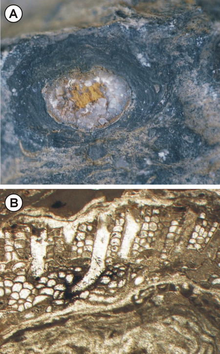
Around the camp two spots can be worth a visit. The steep hill dominating the valley to the north, whose top is located at N35°47’44,89’’ / E76°49’13,98’’ mostly consists of bioclastic calcarenites, very rich in microfossil and especially in oncoids coating the nucleus made by brachiopods (frequently Enteletes) or by bryozoans (Fig. 20). The other interesting spot is a little ahead, near the bank of the river (N35°46’43,86’’ / 76°50’11,82’’). This is the locality where Desio in 1929 collected the brachiopods, later described by Fantini Sestini (1965a).
Figure 20. The large oncoid
The large oncoid built around a crystallized brachiopod (A), is made by algal and bryozoan coatings (B). Scale bar = 1 mm.
Further activities
From the Staghar Glacier it is still possible to walk till the Singhiè Glacier. In 1988 the glacier was damming the valley and usually is unaffordable, if not after a long negotiation. During the 1988 expedition, the famous climber Kurt Diemberger tried to cross it; after one day of attempts he was able to reach hardly the mid of the glacier, fighting against the ice pinnacles. Presumably different glacier conditions allowed Desio in 1929 to cross it with porters in just one day; the same did the topographers of the Visser expedition in 1935. On the right side of the river, just before the glacier snout damming the valley, it would be of high interest to walk up the narrow gorge on the north to cross the upper part of the Aghil dolostone and to reach the red stuff capping this unit, possibly the Marpo Fm. However, we didn’t had the opportunity to examine this particular spot.
Towards Sughet Jangal and the Sarpo Laggo Glacier
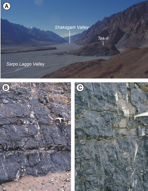
This part of the trek follows the Shaksgam valley downstream till the hillock of the Tek-ri at the junction with the Sarpo Laggo river, then walk up to Sughet Jangal and to the snout of the Sarpo Laggo Glacier, and return via Bdongo-la, or vice versa. The trekking takes two days to Sughet Jangal.
Day 1
From Durbin Jangal it is better to walk on the right bank of the river till Aghil Jangal, where some fodder for camels may be found. The landscape is dominated by the imposing cliffs of the Aghil dolostones and the limestones of the Tek-ri Formation, forming open folds, mostly synclines, cut by faults dipping to the north (Fig. 21). Outcrops of country rocks are not easy to reach, because of huge alluvial terraced deposits. Dolostones with loferitic cycles or megalodontid limestone may be observed where the Aghil Fm. is reachable near the bottom of the valley. At the junction with the Skam river the open syncline already depicted by Auden (1938) and Desio (1980: 44, fig. 11) may be seen. Once the river is crossed, the upper part of the calcareous succession crops out on the opposite bank. It consists of dark-grey thick-bedded limestone (Fig. 22b,c). This is the typical facies of the Tek-ri Formation, with algal oncolites up to 1 cm large. These rocks were ascribed to the Permian Shaksgam Fm. in the map published by Desio (1980), possibly because the oncolites were considered ghost of fusulinids. However, during the 1929 expedition the porters threw away part of the geologic samples and Desio had to rely mostly on his field notes. Yellow conglomerates that apparently end the sedimentary succession are evident in the core of the syncline along the Skam river, and can be studied in the boulders along the valley. A camp can be placed on the left bank of the river, before the junction with the Sarpo Laggo valley.
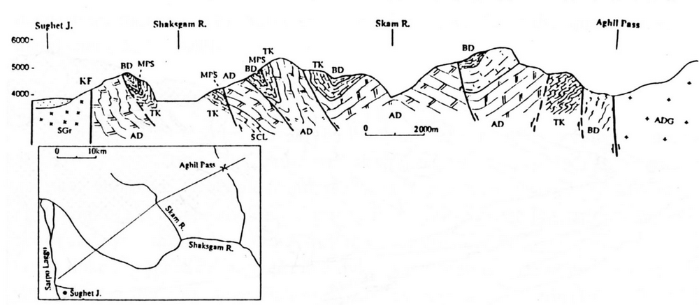
Figure 21. Cross section between Aghil Pass and Sughet Jangal
North dipping isoclinal folds are vertically truncated by the main alignment of the Karakorum Fault. SGr = Sughet Granodiorite, KF = Karakorum Fault, AD = Aghil Dolomite; BD = Bdongo-la Fm.; MPS = Marpo Sandstone, TK = Tek-ri Fm., AGD = Aghil Dara Granodiorite (from Gaetani et al., 1991).
Figure 22. The Tek-ri Formation
A) The Tek-ri hillock at the confluence Sarpo Laggo/Shaksgam, with the dark-grey limestone of the Tek-ri Formation. B) Tek-ri dark-grey limestone in amalgamated nodular beds. Hammer for scale. C) detail of the same outcrop.
Day 2
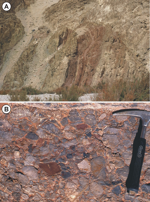
From the Sarpo Laggo junction, a visit to the Tek-ri hillock (Fig. 22a) is recommended in order to get the best view of the K2 north face (Fig. 1). From here the path follows upstream along the right bank of the Sarpo Laggo river, up to a small Jangal. Near the Jangal a short section of grey marls, red siltites, and polygenic breccias (Fig. 23b) may be observed, truncated by a north dipping fault that brings on its hangingwall the Aghil Fm. above this small succession, interpreted as the passage from the Bdongo-la Fm. to the Marpo red unit (Fig. 23).
Figure 23. The Bdongo-la and the Marpo formations
A) The Bdongo-la and the Marpo formations truncated by a fault dipping to north. On the hangingwall is the Aghil Formation. B) Details of the basal levels of the conglomerates of the Marpo Formation; hammer for scale.
Moving along the Sarpo Laggo valley, some 3 km from the Tek-ri, the main alignment of the Karakorum Fault is crossed. The dolostone of the Aghil Fm. is in cataclastic contact with the Sughet Granodiorite. The subvertical cataclasite strip is a few tens m-thick and trends NW-SE. This plutonic body is mostly made of granodiorite and at minor extent of tonalite, with a medium-grained granular texture (Fig. 24c). Zoned plagioclase, quartz, poikolitic alkali feldspar, brown biotite partially replaced by chlorite, minor muscovite and accessory apatite, zircon, and allanite occur.
Figure 24. Sarpo Laggo Valley
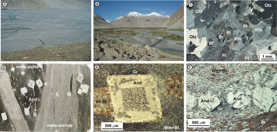
A) Sarpo Laggo valley. The arrow points to the camel caravan emphasizing the impressive size of the braided fan of Sarpo Laggo river. B) Sughet Jangal: itis a “popular” camp site for mountaineering expedition to K2 north face. C) Sughet Granodiorite consisting of zoned plagioclase (Pl), quartz (Qtz), poikolitic alkali feldspar (Kfs) and brown biotite (Bt) partially replaced by chlorite. Sample 108. XPL. D) Peculiar andalusite ± staurolite- bearing graphitic slate from the moraine of the Sarpo Laggo valley. The chiastolitic structure of andalusite is already evident on the hand sample. The slate consists of interbedded pelitic and arenitic cm- thick levels. Scan of the thin section (Sample V1907). E) Chiasolitic andalusite porphyroblast set in fine-grained two-micas + graphite matrix. Sample V1907. PPL. F) Andalusite porphyroblasts in a two-micas + graphite slate. Sample 92. PPL.
Here the Sarpo Laggo valley is imposing wide, not less than 2 km, as may be appreciated from Fig. 24a. Remains of ancient camp sites are found along the side of the valley, possibly built when the iced area was not so expanded and few commercial caravans were able to cross the Muztagh Pass and enter in Baltistan through the Baltoro basin (Younghusband, 1896). Always flanking the Sughet Granodiorite, the itinerary reaches Sughet Jangal which is a “popular” camp site for mountaineering expedition to K2 north face (Fig. 24b). A Chinese military check-point is sometimes set up here.
Along the itinerary, peculiar andalusite ± garnet ± staurolite- bearing graphitic slates may be easily found in the alluvial deposits and in the moraines of the Sarpo Laggo valley, and are probably derived from the upper reaches of the glacier (Desio, 1980). These fine-grained slates are characterized by the occurrence of mm- to cm-sized andalusite porphyroblasts, which appear as whitish spots, often with a chiastolitic structure already evident on the hand sample (Fig. 24d,e,f). The two-micas + andalusite ± garnet ± staurolite assemblage suggests amphibolite-facies peak metamorphic conditions at low pressures (1.5-2.5 kbar).
Further activities
From the Sughet Jangal camp, it is possible to move further to the Skamri Glacier confluence and towards the Sarpo Laggo snout. The metasedimentary rocks along the Skamri valley are less deformed than those on the right side of the Sarpo Laggo valley. Some of the main units of the Permian succession may be recognized and also the fusulinid Monodiexodina cf. shiptoni was identified, indicating a late Early Permian age (Gaetani and Leven, in press) (Figs 3, 25). Metamorphic rocks include orthogneiss, paragneiss, impure marble and pegmatitic aplite associated with the paragneiss (Fig. 26). Orthogneisses are medium-to coarse-grained rocks rich in quartz showing a pervasive schistosity defined by biotite and muscovite preferred orientation. Their petrography and chemical compositions suggest granodioritic and granitic protoliths, linked to the massive intrusions emplaced during the Cretaceous subduction of the Neo-Tethyan Ocean.
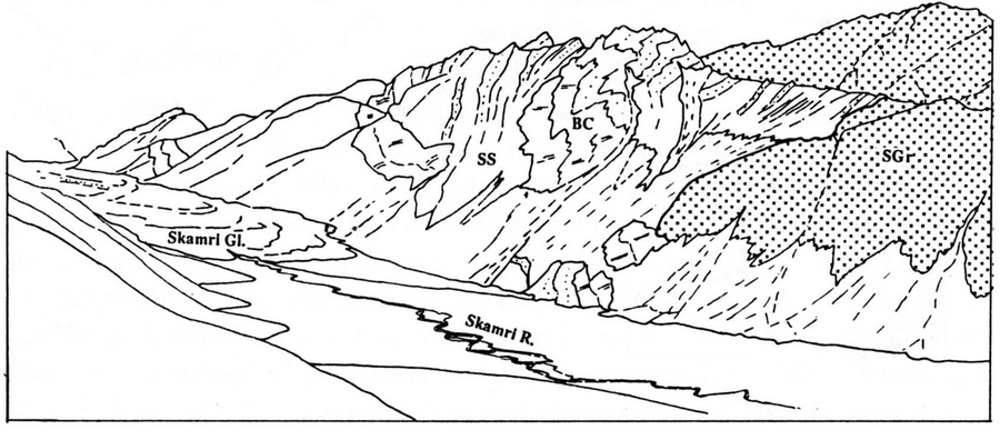
Figure 25. The Sarpo Laggo K2 Metamorphics and the Sughet Graniodiorite
The Sarpo Laggo-K2 Metamorphics and the Sughet Graniodiorite form a south dipping surface on the left bank of the Skamri Glacier and the Sarpo Laggo valley. SS = Sandstones beds; BC = Brown Carbonates; SGR = Sughet Granodiorite. (From Gaetani et al., 1991).
Figure 26. Orthogneiss and layered marbles and metarenites
A) Orthogneiss crosscut by aplitic dykes. Hammer for scale. B) Layered marbles and metarenites of the Sarpo Laggo-K2 Metamorphics. Gloves and hammer for scale.
On the way back, it is recommended to take the trail through the Bdongo-la. From Sughet Jangal, a rather poorly marked trail starts a couple of kms after the crossing of the creek originating from the northern side of K2. From here the view on the lower Shaksgam (Oprang) valley and the lower Sarpo Laggo valley is imposing; one last backward glance can give a spectacular view of the K2 (Fig. 27a). The syncline (Fig. 21) on which the pass is nested contains some of the younger sedimentary rocks of the Shaksgam Sedimentary Belt and some of the best preserved doleritic dykes of Cenozoic age described by Pognante (1990). From the Bdongo-la the path returns to Aghil Jangal, descending mostly on the dark grey limestone of the Tek-ri Formation. On the way back it is convenient to camp here, close to the ascent to the Aghil Pass. Between September and October, the pass transit can be made difficult by early snow (Fig. 27b).
Figure 27. K2 Pyramid and caravan escape
A) Spectacular view of the K2 Pyramid from the Bdongo-la. B) The caravan escaping the Shaksgam valley on the ascent to Aghil Pass, October 6th 1988.