Day 3
This day involves relatively short driving distances and benefits from spectacular outcrops in the coastal headlands between Nambucca Heads and Port Macquarie (Figure 3). The first outcrop is located in Nambucca Heads, within a walking distance from the town centre.
Stop 3.1. Nambucca Head
GPS -30.647226°/ 153.019757°
The headland at the southern end of Shelly Beach provides an excellent exposure of deformed early Permian rocks of the Nambucca Block. The protolith is a siltstone sequence that was supposedly deposited in an extensional rift basin (Korsch et al., 2009), considered to be part of the larger Barnard Basin (Leitch, 1988). In this locality, the rocks are metamorphosed at low greenschist facies conditions and show multiple overprinting crenulation fabrics (Leitch, 1978; Johnston et al., 2002).
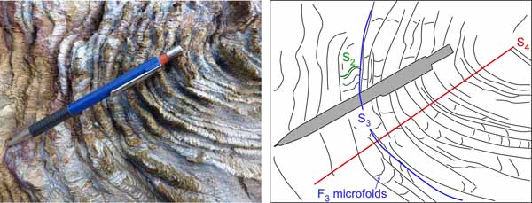
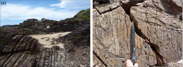
Four generations of structural fabrics can be recognised in this outcrop. The dominant fabric element is defined by the layering of quartz and mica domains (Figure 6) and is generally oriented ~N-S. The differentiation to quartz-mica domains is a characteristic feature of intense crenulation cleavage (Gray, 1977), indicating that the dominant fabric must be an overprinting fabric element (at least an S2) that was superimposed on an earlier structural fabric (S1). In thin sections, traces of S1 are locally recognised in low strain zones within the quartz-rich S2 domains. The prominent crenulations in the quartz-mica domains are F3 folds, and this crenulation cleavage (S3) is further folded around F4 folds (Figure 6).
Figure 6. Nambucca Heads.
Overprinting deformation fabrics in early Permian rocks, Nambucca Heads (Stop 3.1). Note that traces of S1 can only be recognised in low strain zones under the microscope.
The tectonic context of the multiple deformation episodes in the Nambucca Block, and relationship with the process of oroclinal bending, are not entirely understood. Offler and Foster (2008) among others have argued that the earlier E-W structural fabric (S1; better preserved elsewhere within the Nambucca Block), formed during southward indentation of the Coffs Harbour Block. Southward indentation, according to Offler and Foster (2008), was responsible for the formation of the Coffs Harbour Orocline. Offler and Foster (2008) have used Ar-Ar dating to constrain the timing of S1 fabric development at 264-260 Ma, arguing that these ages constrain the timing of oroclinal formation. This model assumes that the Nambucca Block is autochthonous and that oroclinal bending was primarily controlled by a N-S tectonic transport. Alternatively, it is possible that the Nambucca Block is a displaced terrane that was subjected to vertical axis block rotations during oroclinal bending (e.g. Collins et al., 1993). In my opinion, this is a reasonable proposition, given the fact that map-scale curvatures are recognised in the contemporaneous belt of early Permian granitoids. Whether the observed overprinting relationships between structural fabrics represent a progressive rotation of the whole Nambucca block, or changes in the direction of maximum shortening, remains an open question.
Stop 3.2. Scotts Head
GPS -30.745117°/152.998174°
Distance from previous stop: 31 km
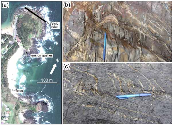
The next headland south of Nambucca Heads also exposes early Permian rocks of the Nambucca succession. Rocks are low-grade fine-grained carbonaceous metasiltstones, metasandstones and calcareous metasiltstones, intruded by younger (Triassic?) felsic dykes (Figure 7a). The structure has been described by Johnston et al. (2002), who recognised microscopic isoclinal F1 folds (in thin sections), overprinted by steeply plunging F2 folds (Figure 7b) and associated NE-SW axial plane cleavage. Later structures include en echelon tension gashes (Figure 7c) and kink bands.
Figure 7. Geology of Scotts Head (Stop 3.2).
(a) Areal (Google Earth) image of the rock platforms in Scotts Head and indications of geological features. (b) Mesoscopic folding with axial planes parallel to the dominant structural fabric. (c) Dextral sense of shear indicated by quartz-filled tension veins.
Stop 3.3. Smoky Cape
GPS: -30.916241°/153.086200°
Distance from previous stop: 51.6 km
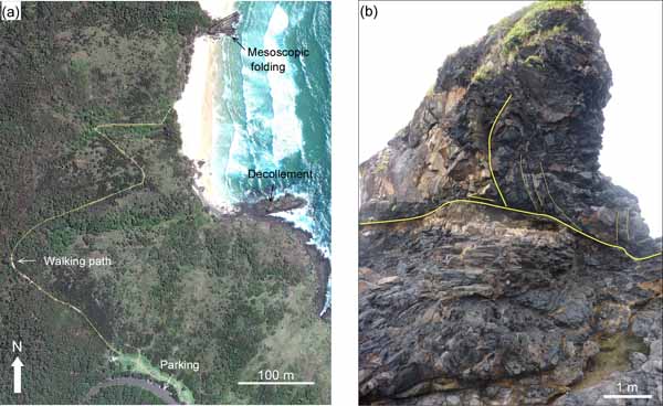
A short (800 m) hike from the car park brings us to beach outcrops (Figure 8a). The rocks in this locality also belong to the early Permian Nambucca Association, and are similar to the metasedimentary succession in Scotts Head (Stop 3.2). However, the outcrop provides an opportunity to better understand the style of folding in the Nambucca Block. The outcrop at the northern edge of the beach shows steeply dipping beds and a mesoscopic fold that is moderately plunging to the NE. The NE-SW axial plane orientation is similar to the axial plane of the F2 folds in Scotts Head. In the southern end of the beach, a recumbent fold seems to be detached from the underlying rocks by sub-horizontal thrust décollements (Figure 8b).
Figure 8. Geology of Smoky Cape (Stop 3.3).
(a) Areal (Google Earth) image showing the coastal outcrops and the trace of the walking trail from the parking area. (b) Mesoscopic folding on top of a sub-horizontal thrust décollement.
Stop 3.4. Crescent Head
Distance from previous stop: 47.5 km
Stop 3.4.1. Sedimentary structures
GPS: -31.186872°/152.983673°
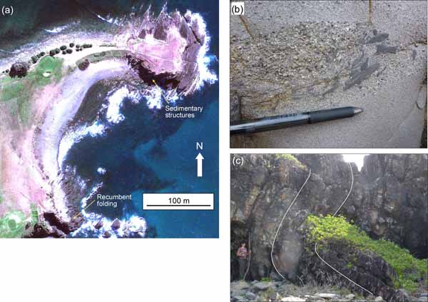
Rocks in this outcrop belong to the Kempsey beds, which is an early Permian succession of turbiditic lithic sandstone, siltstone, diamictite and conglomerate (Runnegar, 1970; Roberts et al., 1995b). Rocks are shallowly dipping to the NW, and are characterised by sandstones with a coarser grained basal interval that has a variety of gravel-sized clasts (Figure 9b). Grey mudstone clasts display current imbrication, in which the shallow dip direction of the inclined clasts points upstream.
Figure 9. Crescent Head.
(a) Geology of Crescent Head (Stop 3.4). (a) Areal (Google Earth) image of Crescent Head. (b) Sedimentary structures showing a coarse grained sandstone layer and imbricated mudstone clasts (Stop 3.4.1). (c) Recumbent fold with a very high interlimb angle (Stop 3.4.2).
Stop 3.4.2. Recumbent folding
GPS: -31.188876°/152.982350°
South of the beach, there are variations in the bedding orientations and mesoscopic recumbent folds (Figure 9c). Similarly to the folds in Smoky Cape (Stop 3.3), these folds are underlain by horizontal décollements. Asymmetric en echelon tension gashes suggest sinistral shearing.
Stop 3.5. Racecourse Head
GPS: -31.251065°/152.968302°
Distance from previous stop: 9 km
The last stop today is a well-preserved package of alternating siliceous metasandstone and metasiltstone (Figure 10a). The rocks, which belong to the Upper Devonian Touchwood Fm (Roberts et al., 1995b), are part of the northern Hastings Block, and were deposited in the forearc region of the Devonian-Carboniferous subduction zone. The stratigraphy is supposedly correlative to the Tamworth Belt (Roberts et al., 1995b; Glen and Roberts, 2012) (Figure 1b). In this locality, rocks are steeply dipping and oriented E-W. A spaced subvertical structural fabric, oriented ~N-S (perpendicular to bedding), is also recognised (Figure 10b).
Figure 10. The Hastings Block in Racecourse Head (Stop 3.5).
(a) Steeply dipping strata of alternating siliceous metasandstone and metasiltstone layers. (b) Spaced subvertical ~N-S structural fabric perpendicular to bedding.
The Hastings Block was possibly displaced and rotated to its current position during the formation of the Manning Orocline. Palaeomagnetic data indicate that the Hastings Block was subjected to a large degree of block rotation, but whether this rotation was clockwise (Schmidt et al., 1994) or counterclockwise (Klootwijk, 2009) is debated. Cawood et al. (2011b) recently concluded that existing palaeomagnetic data are insufficient to support a unique kinematic reconstruction of the Hastings Block and Manning Orocline. Nevertheless, the authors suggested a preferred model, which involves oroclinal bending accompanied by large displacement sinistral shearing. An alternative model involving much smaller displacements and no shearing has recently been proposed by Glen and Roberts (2012).
The day concludes in the town of Port Macquarie, a distance of 72.5 km from the last stop.