Geological setting and deep structures
Any attempt to analyze the relationships between the Western Alps and the Northern Apennines implies a definition and understanding of the present geometries and tectonic setting of various geological domains as well as the successive kinematic stages of retrodeformation of structures only locally directly observable (Laubscher, 1971; Elter and Pertusati, 1973; Laubscher 1988; 1991; Polino et al., 1993; Schumacher and Laubscher, 1996; Mosca et al., 2009 and references therein).
As a matter of fact, the junction area between the two chains includes three major geomorphological domains (Figs. 1-4), each largely composite from a geological point of view, corresponding to:
- a south-western undersea region, the Ligurian Sea -- belonging to the Liguro-Provençal basin and to the Northern Tyrrhenian sea--;
- an “S-shaped” mountain range formed by the Cottian-Maritime, Ligurian Alps and the northern sector of the Apennines;
- a north-eastern region comprising former exhumed sectors of the orogenic belt partially subsided during Oligocene-Miocene (to form the so-called Tertiary Piemonte basin) and during the Neogene to form foredeep basins resting on Adria Mesozoic carbonate successions and covered by thick alluvial sediments of the present Po plain.
Structures in all the three geological domains record, at different degrees, the interfering relationships between two growing and evolving orogens as described below.
Figure 1. Relief image of north west Italy and adjacent region.
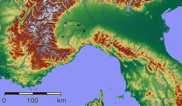
(after Wikipedia commons; http://commons.wikipmedia.org.wiki). AL, Alessandria basin; La, Langhe hills; MO, Monferrato hills;, SV, Savigliano plain; TH, Torino, hills.
Figure 2. Tectonic map of Western Alps/Northern Apennine junction area, with inset of the main structural domains of the system.
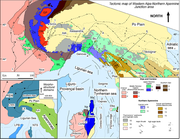
In the inset: CMA Cottian-Maritime Alps; LA Ligurian Alps, NA Northern Apennine; LPB Liguro-Provençal basin (dark blue oceanic crust); NTS Northern Tyrrhenian sea. In the map the main tectonic and lithostratigraphic units of the system are shown. For the Western Alps: (1,2) Europe-derived external Alpine units and external part of Corsica. 1) Alpine foreland units; (2) External massifs (Ar, Argentera and P, Pelvoux); (3) Middle Penninic Briançonnais nappes in the Alps and the Tenda unit in Corsica (4) Middle Penninic Internal Massif (DM, Dora Maira and GP, Gran Paradiso); (5) Upper Penninic Helminthoid Flysch: UE, Ubaye-Embrunais, Western Liguria Helminthoid Flysch (WL) and the Antola unit (A). With the same color are also represented the ophiolitic non-metamorphic unit of Chenaillet (Ch) and Sestri Voltaggio Zone (SVZ) and in Corsica Balagne (Ba), Nebbio (Ne) and Macinaggio (Ma) units; (6) Schistes Lustrés composite nappe system; (7) Sesia and related units (“lower Austroalpine nappes”); (8) Adria lower crust of the Southern Alps (Ivrea); (9) Adria upper crust basement and cover of the Southern Alps; Northern Apennine: (10) Internal Ligurian units, IL; (11) External Ligurian units (EL) and SubLigurian (Canetolo) units; (12, 13, 14) Adria-derived Tuscan and external foreland Umbria-Marche units; (12) Tuscan nappe; (13) Tuscan metamorphic units; (14) Cervarola and Umbria-Marche foreland units; (15) Post-tectonic cover of Tertiary Piemontese basin and Epiligurian units; (16) Neogene and Quaternary sediments of Po Plain and inner Tuscany (17) Magmatic rocks of Southern Tuscany, volcanic and intrusive bodies; major thrusts at surface (18) and in subsurface (19); (20) high angle normal and trascurrent faults; (21) sediment thickness in seconds TWTt for the Tyrrhenian Sea; (22) Pliocene isobaths (in Km) in the Po Plain and Adriatic sea.
Figure 3. Map of crust-mantle configuration of the Western Alps/Northern Apennine junction area.
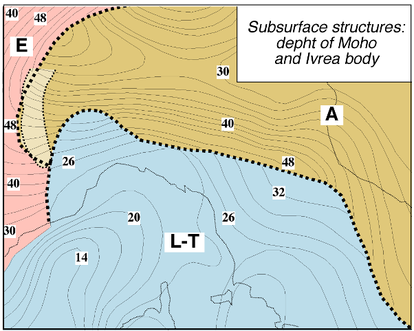
Contour intervals of 2 Km. Dashed lines indicate the limits between the European (E), Adriatic (A) and Ligurian-Tyrrhenian (L-T) Mohos. The Ivrea geophysical body is also reported. From Lanza, 1984; Laubscher, 1988; Cassinis et al., 2002, Waldhauser et al., 1998; Schmid and Kissling, 2000; Scafidi et al., 2009 and references therein.
The 3D Moho configuration of the junction area (Fig.3) also reflects this complex evolution and it is characterized by three Moho sub-interfaces (Solarino et al., 1997; Waldhauser et al., 1998; Dezes and Zigler, 2002; Cassinis et al., 2002; Scafidi et al., 2009): the European Moho, southward dipping; the Adriatic Moho, characterized by updoming below the Po plain, shallow northward dip in the north and a southward underthrusting below the Apennines; the Ligurian Moho located at shallow depth beneath the Ligurian sea and the Apennines with a slightly north-dipping attitude and further south, the Tyrrhenian Moho.
A significant element in the deep structure of the area is represented by the Ivrea body (Fig.3), which is geophysically defined as having: high density and magnetic susceptibility, seismic velocity and positive Bouger anomaly corresponding to material of lower crust or upper mantel origin (Lanza, 1984; Solarino et al., 1997; Scafidi et al., 2009). This is in agreement with its surface correlative represented by ultramaphic rocks of lower crustal and upper mantle origin exposed just south of the Insubric line in the Central Alps (Lanza, 1984; Solarino et al., 1997; Ford et al., 2006; Schmid and Kissling, 2000; Schmid et al., 1996; Scafidi et al., 2009).
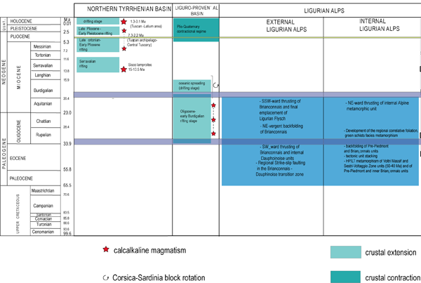
Figure 4. Age of the main geological events in the domains of the of Western Alps/Northern Apennine junction area.
TM units: Tuscan Metamorphic units; T, U-M, R units: Tuscan, Umbro-Marche and Romagna units.
JVE subscribers can download a full size version of figure 4 at http://virtualexplorer.com.au/article/2010/215/apennine-alps/media/figure04-full.png.
The south-western domain: the Liguro-Provençal and Northern Tyrrhenian basins
The south-western domain includes an undersea region geologically belonging to two different provinces: the Liguro-Provençal basin and the northern part of the Tyrrhenian basin (Fig.1,2,4).
Both basins are presently interpreted by most authors (for alternative views see Boccaletti et al., 1982) as Late Oligocene to Miocene back-arc basins developed in relationships with Apulian westward subduction and eastward slab retreat (Patacca and Scandone, 1989; Doglioni, 1991). These basins are therefore parts of the Northern Apennine geodynamic system, since they developed during its successive stages of evolution (Gueguen et al., 1998; Faccenna et al., 1998).
The rifting stages in the Liguro-Provençal basin are dated to Oligocene to Early Miocene (Aquitanian–early Burdigalian) and are associated with important calcalkaline magmatism on land (Lustrino et al., 2008). The following oceanic spreading (drifting stage) occurred in the Burdigalian (19–16 Ma) with formation of an atypical oceanic crust (Gueguen et al., 1998; Fanucci and Morelli, 2003; Rollet et al., 2002) characterized by discontinuous tholeitic volcanic edifices settled within the exhumed mantle, related with slow-to very slow (less than 1-2 cm/yr) tectonically controlled oceanic spreading (Chamot-Rooke et al., 1999; Rollet et al., 2002). The drifting stage and oceanic accretion were associated with the anticlockwise Corsica-Sardinia block-rotation of 30° (Speranza et al. 2002; Maffione et al., 2008) or 45-50° (Gattacceca et al., 2007). The rotation occurred after Aquitanian and was essentially completed at about 15 Ma according to Gattacceca et al. (2007). A third of the total amount of rotation occurred at a rate of c.15°/Ma between 20.5 and 18 Ma (Rehault et al., 1986; Gattacceca et al., 2007)
It is important to notice that the (trans-) extensional processes of the Liguro-Provençal basin partially occurred in an area previously forming the external southern zone of the Pyreneean range (whose north-westward continuation is not well defined) where orogeny had stopped c.10 Myr earlier (Seranne 1999; Lacombe and Jolivet 2005).
The present day tectonic activity of the western part of the domain (westernmost part of Liguro-Provençal basin) is characterized by contractional reactivations of previously developed extensional structures in relationship with ongoing tectonics of the southwestern Alps (e.g. Eva and Solarino, 1997; Bigot Cormier et al., 2006; Sue et al., 2007; Larroque et al., 2009).
The south-eastern segment of the domain geologically belongs to the Northern Tyrrhenian Sea which separates the Northern Apennine from Corsica and is subdivided into two main parts (Figs. 2 and 4): a western domain—the Corsica basin—and an eastern one— the Tuscan shelf, separated by the north–south elongated Elba–Pianosa Ridge (Bartole et al. 1991; Carmignani et al. 1995; Mauffret and Contrucci 1999; Pascucci et al. 1999; Cornamusini et al. 2002).
The north/south structures are poorly defined in their northern prolongation and the general structural trends turned to north-west/south-east in the eastern Ligurian sea. The major structure in the eastern side is represented by the Plio-Quaternary Viareggio basin (Fanucci and Nicolich, 1984; Bernini et al., 1990; Argnani et al., 1997)
The Northern Tyrrhenian Sea developed since early Middle Miocene with the rifting of the half-graben of the Corsica basin and then since Late Tortonian (Middle–Late Miocene) with the rifting of the eastern part of the Tuscan shelf.
The formation of Miocene and younger basins was associated with magmatism which also shows an eastward-younging trend between Middle Miocene and Quaternary. Sisco lamproites (alkaline sills) in eastern Corsica represent the oldest magmatic rocks (15–13.5 Ma), while intermediate age magmatism (7.3–2.2 Ma) characterizes the intrusive and volcanic bodies of the Tuscan Archipelago and Central Tuscany (e.g. Capraia, Elba, Giglio, Orciatico, Montecatini Val di Cecina). The easternmost and recent (1.3–0.1 Ma) magmatism can be found in the Tuscan–Latium area at Mt. Cimini, Mt. Vulsini, Mt. Amiata and Larderello (Civetta et al. 1978; Lavecchia and Stoppa 1990; Serri et al. 1993; Musumeci et al. 2002; Rosenbaum and Lister, 2002; Conticelli et al., 2009 and this volume).
The “S-shaped” mountain range
The junction area between the Alps and the Apennines includes an “S-shaped” mountain range formed by the Cottian and Maritimes Alps (the southern part of Western Alps), the Ligurian Alps and the northern sector of the Apennines (Fig.2).
The Cottian and Maritime Alps (CMA)
The Cottian-Maritime and the Ligurian Alps consist of several tectonic units that can be stratigraphically referred to the major paleogeographical domains of the western Tethys. From WSW to ENE they are the European continental margin; the Briançonnais/sub-Briançonnais domains (distal part of the European continental margin or independent terrane according to different interpretations e.g. Lemoine et al., 2001 ; Stampfli et al., 1998 ; Schmid et al.1996, 2000) and finally the Ligurian oceanic realm.
The external zones of the orogen in the Cottian and Maritime Alps are exposed west of the Frontal Briançonnais Fault (FBF). They comprise a foreland thrust system, forming the Digne and Castellane-Nice arcs, which consist of Eocene-Oligocene foreland basin sequences floored by thick Mesozoic carbonates of the Dauphinois domain (Sinclair, 1996; Ford et al., 1999). These sediments lay on a Variscan basement exposed in the Argentera Massif (Bigot-Cormier et al., 2006), and are in turn overlain by the very-low-grade Embrunais-Ubaye nappes, consisting of Late Cretaceous – Paleocene Piedmont-Ligurian Flysch and Helmintoid Flysch of the Parpaillon Nappe (Kerchove, 1969; Michard et al., 2004).
East of the Frontal Briançonnais Fault, blueschist-to-greenschist facies units are exposed inside the so-called Briançonnais fan. The western part of the Briançonnais fan consists of Briançonnais cover sequences of Carboniferous-to-Eocene age and, in places, Subbriançonnais sequences stacked along the Frontal Briançonnais Fault (Fabre, 1961; Gidon 1962; Michard 1967; Barfety et al., 1996). Peak pressure in these units never exceeds 2 GPa (Agard et al. 2002; Malusà et al. 2002; Ganne et al. 2006). The eastern part of the Briançonnais fan consists of Briançonnais basement units (Desmons, 1992; Malusà et al. 2002, Ganne et al. 2006), continental margin cover rocks, calcschists and ophiolites (Caron 1977; Agard et al. 2002; Schwartz et al. 2007). In the Queyras “Schistes Lustres”, kilometer-scale metaophiolites slivers embedded within Mesozoic metasedimentary rocks (Lemoine and Tricart, 1986; Lagabrielle et al.), show increasing PT conditions ranging from LT-blueschist facies condition to the west, to transitional blueschist-eclogite facies to the east, just west of the Viso unit. These ophiolitic nappes are topped by the non-metamorphic Chenaillet ophiolites (Lemoine et al. 2001; Scharwz et al. 2007).
Higher-pressure units crop out in an innermost position in front of the Western Po Plain. The Dora-Maira unit, i.e. the southernmost Internal Crystalline Massif of the French literature, chiefly consists of metasedimentary and metagranitoid rocks (Vialon, 1966), and is classically referred to the distal European margin (Lemoine 1986, 2000) or to the northern tip of the Briançonnais-Iberia terrane (Stampfli et al.1998). The Dora-Maira unit displays an eclogite facies metamorphic overprint of Alpine age, locally reaching ultra-high pressure conditions as inferred in the Brossasco-Isasca slice (ca. 3 GPa at 35 Ma) (Chopin et al.1991; Compagnoni, 2003; Rubatto and Hermann 2001). The Dora-Maira unit is overlain by eclogite-facies ophiolites, like those exposed in the Viso unit. The Viso ophiolites reached a peak pressure >2 GPa at ca 45-40 Ma, and were exhumed (see below) at shallow crustal level at ca 20 Ma (Cliff et al. 1998; Messiga et al., 1999; Schwartz et al. 2000, 2007; Rubatto and Hermann 2001).
The Ligurian Alps (LA)
The Cottian Maritime Alps pass southeastward to the Ligurian Alps LA through a composite fault zone boundary described below. The Ligurian Alps represent a peculiar sector of the belt where different tectonic units were distinguished (more than 20 units according to Seno et al. 2005a). According to paleogeographical reconstructions (e.g. Vanossi 1980; Lemoine et al. 1986; Stampfli 1993; Dal Piaz 1999), it may be assumed that the different tectonic units originally belonged to the continental European/Briançonnais margin(s), including part of its more distal margin (Prepiedmont of the authors), and to the Piemonte-Ligurian oceanic domain.
In the external zone of the belt (Fig.8 and see below) the units of the Dauphinois-Provençal domain of the Nice arc are directly overthrusted (in the western Ligurian Alps) by the Paleocene-Upper Cretaceous Flysch nappes subdivided from southwest to northeast into three major units: S.Remo, Moglio Testico and Alassio-Borghetto (Helminthoid Flysch nappes of Western Liguria; Vanossi et al., 1984; Seno et al. 2005). The Helminthoid Flysches represent the top of the LA nappe stack and overthrust at their north/north-east termination (Eastern Ligurian Alps) the Prepiedmont and Briançonnais units.
The Briançonnais units are divided in External units and Internal units, composed of a Pre-Namurian basement (exposed only in the Internal units; Seno et al., 2005), volcanic and continental clastic deposits (Permian to early Triassic in age; Cortesogno et al., 1993; Seno et al., 2005) with a detached Meso-cenozoic cover sequence. The external units display a very low to low-grade Alpine metamorphic overprint (anchizone up to greenschist facies; Seno et al. 2005) whereas the Internal Briançonnais units reach peak conditions up to P ≈ 1.3 GPa and T > 400°C (Cabella et al., 1994).
The Prepiedmont units show a stratigraphic succession and basement features different from those of the Briançonnais thoroughly described by Dal Piaz (this volume), while the basement units are overprinted by Alpine metamorphism estimated at P = 1.5 GPa and T= 550 ± 30 C° (Cortesogno et al., 2002).
Starting since Late Eocene up to Early Oligocene, the Prepiedmont and Briançonnais units underwent a SSW-ward directed stacking (and see below), followed by an almost co-axial backfolding event, whose intensity decreases towards the outer SW sectors. A later phase (Late Oligocene-Early Miocene ?) of thrusting and associated development of large scale open folds, verging SSW, finally occurred resulting in a complex transpressional setting, with juxtaposed folded and sheared domains occurring at several scales (Gosso et al., 1983; Seno et al., 2005; Piana et al., 2009).
The innermost units of the LA are represented by the HP-LT units of the Voltri Massif (or Voltri Group, Chiesa et al. 1975) and by three tectonometamorphic units (Cravasco-Voltaggio-Montenotte-CNMU, Gazzo-Isoverde-GIU, Figogna unit-FU) historically referred to as the Sestri–Voltaggio Zone (Cortesogno and Haccard 1984).
The Voltri Massif consists of two main tectonometamorphic units (Voltri Unit and Palmaro-Caffarella Unit, Capponi and Crispini, 2009) composed by high pressure metamorphic ophiolites. The ophiolites consist of serpentinites with metagabbros and metabasites, metasediments and mantle peridotites, with peak eclogite (450–500 °C and 1.3–2.0 GPa for the Voltri Unit; Messiga and Scambelluri, 1991, Liou et al. 1998, Federico et al., 2005) or blueschist (c.a. 350-400 °C and 1.2 GPa for the Palmaro-Caffarella Unit; Desmons et al. 1999) syntectonic alpine metamorphism, strongly overprinted by greenschist facies fabrics (Capponi and Crispini 2002). These units show superposed deformation structures, formed at different crustal conditions. Subduction related structures are represented by eclogite facies foliation and rootless hinges of isoclinal folds, occuring all over the massif as early relic structures. Deformations linked to the exhumation and nappe stacking are represented by Na-amphibole greenschist to greenschist facies s.s. folds and schistosities. These are the most evident structures in the field and control the contacts between different lithologies (Capponi and Crispini 2002, Federico et al. 2009 and bibliography therein).
The last stages of the tectonic evolution in the Voltri Massif are characterized by superposed brittle-ductile and brittle structures linked to transpressional tectonics (described in Spagnolo et al. 2007; Crispini et al. 2009).
The GIU and the CVMU units are separated from the Voltri Massif by the Sestri-Voltaggio Line (Cortesogno and Haccard 1984) that at present is a steeply dipping N-S oriented km-scale fault. Most deformation predated the Oligocene, since the main structures are sealed by the Oligocene-Miocene formations of the Tertiary Piemontese Basin, even if later reactivations can be locally observed (see below). To the east the units of the Sestri-Voltaggio zone are in contact with very low-grade flysch units (Ronco, Mignanego and Montanesi Units Capponi and Crispini, 2008) and the unmetamorphosed Antola flysch unit (correlated with the External Ligurian units; Abbate and Sagri 1984 and references; Ellero, 2000; Cerrina et al. 2002; Levi et al. 2006).
The CVMU and the FU are metaophiolitic units and are re-equilibrated respectively in low-T blueschist facies (T= 300-350° C and Pmin= 0.8-1.0 GPa for the CVMU; Cabella et al., 1994, Desmons et al. 1999) and pumpellyite–actinolite facies conditions (T= 300-350° C and P= 0.7, Desmons et al. 1999). The GIU comprises carbonate rocks and shales of Triassic to early Jurassic age, which attained the same blueschist facies metamorphic conditions of CMVU. The FU shows a polyphase structural evolution but developed at lower metamorphic conditions.
The timing of the high pressure metamorphic events in the internal units of the Ligurian Alps are constrained between ca. 50 Ma (eclogite facies) and 40 Ma (blueschist facies) in metaophiolitic rocks (Federico et al. 2005). Greenschist-facies retrogression during exhumation is locally dated at ca. 33 Ma (Federico et al. 2005). In the continental units of the Internal Briançonnais Early (Middle?) Eocene metasediments record blueschist facies overprint (e.g. Seno et al., 2005).
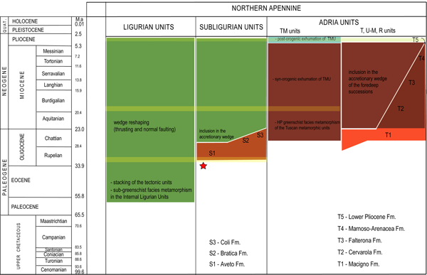
The Northern Apennine (NA)
The uppermost units of the Northern Apennine nappe stack are represented by the Ligurian units. These units can be subdivided on the basis of stratigraphic and structural features into two main groups (Elter 1975) well defined in the Ligurian–Emilian Apennine (Fig.2): the Internal Ligurian Units and the external Ligurian units. The former are characterized by the presence of ophiolites and an Upper Jurassic to Lower Cretaceous sedimentary cover (cherts, Calpionella limestone and Palombini shales) associated with Upper Cretaceous–Paleocene turbiditic sequences (Molli, 2008 and ref.). The Internal Ligurian units are considered as remnants of the Liguro-Piemontese ocean or Ligurian Tethys. The External Ligurian Units are, on the other hand, distinguishable for the presence of the typical Cretaceous–Paleocene calcareous dominant sequences (the Helminthoid Flysch) associated with complexes or pre-flysch formations called ‘basal complexes’. According to their stratigraphic differences, two main subgroups of units can be recognized (Molli, 1996; Marroni et al. 1998 and references): those associated with ophiolites and with ophiolite derived debris, and others without ophiolites and associated with fragments of Mesozoic sedimentary sequences and conglomerates with Adria affinity (Sturani 1973; Zanzucchi 1988; Molli, 1996). Because of their age (Elter et al. 1966; Wildi 1985; Zanzucchi 1988; Gasinski et al. 1997; Daniele and Plesi 2000) and composition, these coarse-grained conglomerates (Salti del Diavolo Conglomerates) have been compared since the early 1970s with those of Pre-alpes Romandes (Mocausa conglomerates of the Simme Flysch) implying a common palaeotectonic setting on the distal side of the Adria continental margin (e.g. Elter 1997; Stampfli et al. 1998; Lemoine et al. 2001 and references). As a whole, the External Ligurian units can be regarded as relicts of the former ocean–continent transition area and of the distal Adria continental margin in the Apenninic transect (Molli 1996; Marroni et al. 1998 and references therein). The Internal Ligurian units suffered polyphase deformation and metamorphism in sub-greenschist facies conditions (prehnite–pumpellyite in metabasic rocks), whereas the External Ligurian units were deformed at shallow structural levels (diagenesis–anchizone transition in pelites).
Among the Ligurian units, the Antola Nappe deserves a special mention. From the lithostratigraphic point of view, this unit can be correlated with the External Ligurian units (Abbate and Sagri 1984 and references; Cerrina et al. 2002; Levi et al. 2006), even though it occupies a structural position at the top of the Internal Ligurian units, in contrast to the other External Ligurian units which are structurally below the Internal Ligurian units. Moreover, it is classically correlated with the Helminthoid Flysch of the Ligurian and Maritime Alps and therefore played a special role during the pre-Oligocene evolution of the Alps/Apennine orogenic system (Elter and Pertusati 1973; Elter 1997; Corsi et al. 2001) as we will see hereafter.
The sub-Ligurian units crop out geometrically below the composite Ligurian system and are characterized by a strong thickness variability at the regional scale. The sub-Ligurian units are represented (Plesi 1975; Cerrina Feroni et al. 2002 and references therein) by Cretaceous–Eocene sequences mainly formed by sandstones and shaly-calcareous deposits (Ostia–Scabiazze and Canetolo fms) followed by Oligocene–lower Miocene (Aquitanian) siliciclastic and marly deposits (Aveto–Petrignacola and Coli units). Within the Cretaceous–Paleogene sequence, unconformities and depositional hiatuses (Vescovi 1993, 1998) of Early, Middle and Late Eocene age are documented, whereas volcanoclastic deposits with calc-alkaline affinities (the Aveto–Petrignacola fm.) are dated to the lower Oligocene. For its age and composition, the Aveto–Petrignacola fm., has been associated with calc-alkaline volcanic centres located on the inner (Adria) side of the Alpine belt (Boccaletti et al. 1971; Ruffini et al. 1995; Cibin et al. 1998).
The original substratum of the sub-Ligurian units is unknown, although it can be considered transitional between the oceanic Ligurian and continental Tuscan domains and probably characterized by a thinned continental crust like part of the External Ligurian domain (Ghiselli et al. 1991; Cerrina Feroni et al. 2002). The lower Oligocene–Aquitanian part of the sequence can be connected with the early accretional and thrust top basins of the Apennine wedge and bears similarities with siliciclastic turbidites at the top of the Tuscan units. The sub-Ligurian units were deformed at shallow structural levels (anchimetamorphic conditions in pelites, Cerrina et al. 1985) starting from Rupelian (c. 30 Ma) (Cerrina et al. 2002, 2004 and references). Below the sub-Ligurian units lie the so called Tuscan units which are representative of the former proximal side of the Adria continental margin (i.e. the Tuscan Domain). These units are formed by continental successions subdivided into different thrust sheets, some of which were deformed at shallow structural levels (e.g. the Tuscan nappe), whereas others were more deeply involved in the collisional stack and metamorphosed during Late Oligocene-early Miocene (Kligfield et al., 1986; Monie et al., 2000) in high- and medium-pressure greenschist facies conditions (up to 0,6-0,8 GPa and 450 °C in the Alpi Apuane and 1 GPa and 350 °C further south in the Montagnola Senese-Argentario Theye et al., 1997; Giorgetti et al., 1998; Molli et al., 2000; Liotta, 2002), forming the so-called Tuscan metamorphic units. These units crop out (Fig. 5) in tectonic windows forming an arcuate belt from P. Bianca in the north through the Alpi Apuane, M. Pisani, Montagnola Senese and M Romani in the south, along the so-called Mid-Tuscan metamorphic ridge. The stratigraphic evolution of the Tuscan sequences testifies the sedimentation on a passive continental margin during Mesozoic rifting and post-rifting stages related with the Ligurian ocean opening (Bernoulli et al., 1979; Bernoulli, 2001; Ciarapica and Passeri, 2002). Sedimentary response to regional-scale contraction and tectonic inversion is recorded during the Cretaceous and Eocene within the Scaglia fm. where conglomerates and unconformities can be observed (Fazzuoli et al., 1994). The sedimentary history in the Tuscan domain ends during the Oligocene and Early Miocene with siliciclastic turbidites (Pseudomacigno and Macigno) interpreted as clastic wedges of Apennine foredeep and wedge top basins. Umbria-Romagna-Marche units are well exposed in the southernmost outer Northern Apennine where they are characterized by Jurassic to Palaeogene carbonates and Mio-Plio-Pleistocene marine clastic sediments deposited in a foredeep and/or in wedge top basins which evolved during thrusting. These units are mainly represented in outcrop exposure by a turbiditic clastic wedge (Marnosa–Arenacea fm. and Laga fm.) deformed as a classical foreland fold and thrust belt (Calamita et al., 1994; Tavarnelli, 1997; Coward et al., 1999; Barchi et al., 2001).
Figure 5. Wheeler diagram showing the stratigraphic framework of Tertiary Piedmont Basin.
From Rossi et al., 2009: principal and minor sequence boundaries, major syndepositional tectonic elements, lithostratigraphic units and gross facies distribution are shown. Unconformities (from bottom to top): B-PR, base Priabonian; I-PR, intra-Priabonian; L-PR, Late Priabonian; B-RU, base Rupelian; I-RU, intra-Rupelian; L-RU, Late Rupelian; B-CH, base Chattian; L-CH, latest Chattian; I-BU, intra-Burdigalian; L-BU, Late Burdigalian; B-LA, base Langhian; B-SE, Base Serravallian; L-SE, Late Serravallian; L-TO, Late Tortonian; I-ME, intra-Messinian; L-ME, Late Messinian. See Rossi et al., 2009 for a detailed description of unconformity-bounded units.
Late- to post-orogenic sediments (Late Eocene to Pliocene in age) of continental to shallow marine origin can be locally observed lying unconformably on the Helminthoid Flysch units in the northern part of the belt where they form the so called Epiligurian units (Elter 1975) as illustrated below. Further south, other Late- to post-orogenic sediments (Oligocene to Pliocene in age) form basins within the Northern Tyrrhenian realm and Southern Tuscany (Cornamusini et al., 2002; Brogi and Liotta, 2008.
The north-eastern domain
The north-eastern domain includes the Po Plain and the marine realm of the Adriatic sea further south-east (Figs. 1,2). The Po Plain identifies a c. 500 Km long east-west trending Neogene basin, bordered to the north by the south-vergent fold and thrust belt of the southern Alps, and to the south by the north/north-east vergent structures of the Apennines (Roure et al., 1990; Mosca et al., 2009).
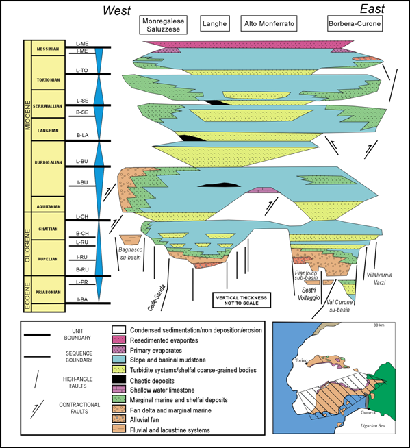
The western termination of the Po Plain in spite of its name shows a very changing geomorphology. From the geomorphological point of view it can be subdivided into a few main provinces (Fig.1): the hilly systems of the Torino Hill-Monferrato to the north and of the Langhe to the south, where Upper Eocene-Oligocene to Miocene rocks are exposed, together with their interposed Savigliano and Alessandria plains, in turn separated by the Asti hills (Fig. 1,2,5).
The Upper Eocene-Oligocene to Miocene successions outcropping in the present map view (Fig.5) record partially different tectono-depositional histories, but they belonged to a single Cenozoic depositional realm, which in this paper will be referred to as Tertiary Piedmont Basin (TPB). The northern outcrops (Monferrato and Torino Hill areas of the literature) are described below as the northern Tertiary Piedmont Basin to distinguish them from the southern ones (Monregalese, Langhe, Alto Monferrato and Borbera-Curone areas of the literature) of the southern Tertiary Piedmont Basin. The primary lateral continuity of the northern and southern TPB successions as well as their relationships are masked by Pliocene to Holocene successions, that fill the Savigliano and Alessandria depocenters (Mosca, 2006).
As identifiable in Fig.5 and 6, the south TPB sediments unconformably rest on nappe-stack of the LA and non-to-low metamorphic Ligurian units. They are characterized by siliciclastic deposits (reaching thickness on the order of 4000 m in its central-western part), and form at the regional scale a gentle north-westward dipping monocline showing great facies variability. Upper Eocene deposits are preserved only locally to the east (Borbera-Gruea area) and consist of mudstones (Monte Piano Marls) upward followed by quartz-rich turbidites (Pizzo d’Oca) and shelf to marginal-marine facies (Rio Trebbio unit) (Cavanna et al., 1989; Di Giulio, 1989; Mutti et al., 1995; Di Giulio and Galbiati 1995).
In the southern TPB, continental to transitional facies are characteristic of Upper Eocene-Lower Oligocene successions (Lorenz 1969; Cavanna et al., 1989, Ghibaudo et al. 1985; Gelati et al. 1993; Mutti et al. 2002; Rossi et al., 2009); shelf to slope marly successions with turbidites were deposited during Late Oligocene and Early Miocene times (Cavanna et al., 1989, Ghibaudo et al. 1985; Gelati et al. 1993; Mutti et al. 2002; Rossi et al, 2009) followed by development of shelfal environments in the Early Burdigalian (Alto Monferrato area: d’Atri, 1990; Piana et al., 1997).
By contrast, the northern TPB shows more condensed successions on locally outcropping Ligurian Helminthoid Flysch units (Elter et al., 1966; Sturani, 1973a). These Helminthoid Flysch units show the same general characters of the External Ligurian units originally deposited from the distal stretched side of the Adria continental margin. In general, lowermost portions of these outcrops consist of basinal mudstones (Monte Piano Marls), followed in the Oligocene-Miocene by shallow water clastic and carbonate facies (e.g. Clari et al. 1995; Dela Pierre et al. 2002a); relative coarse-grained facies significantly characterize the western outcrops (Torino Hill area e.g. Bonsignore at al. 1969; Sturani 1973), resting on a buried south-verging South-Alpine belt (Mosca 2006; Mosca et al. 2009).
The uppermost portions of the outcropping TPB strata are represented by widespread homogenous marly sediments of Tortonian age, and by discontinuous evaporites and lagoon clays recording the Messinian salinity crisis, often in form of chaotic and/or resedimented assemblages (Irace et al., 2005; Dela Pierre et al., 2002b).
In present outcrop exposures, lowermost Pliocene deposits are typically represented by marine clays followed upward by Pliocene sand-rich marginal marine and Pleistocene to Holocene continental successions (Boni, 1984; Carraro, 1996 and references therein).
So, the present configuration of the WPP implies that the 3D tectono-depositional evolution of this area must be necessarily reconstructed considering features of present-day outcrops as well as their buried prosecutions, namely integrating field and subsurface data as will be seen later on.