Mound springs are natural discharge points for the artesian water which flows through the Great Artesian Basin. The basin occupies approximately 1.7 million km2 across Queensland, New SouthWales, South Australia and the Northern Territory (Figure 1 in Aldam and Kuang, 1989). It represents the largest geological unit on the Australian continent, comprising mid-Triassic to Cretaceous continental quartz sandstones confined by beds of siltstone and mudstone (Habermehl, 1986a). The major recharge zone is in the east, where the sandstone aquifers outcrop within the Great Dividing Range, with minor recharge occuring on the western margin (Thomson and Barnett, 1985). Prior to European exploitation of its water resources, the high potentiometric surface at the recharge zones effectively pressurised the entire basin. This was balanced by discharge in the form of vertical leakage through the confining beds, and mound spring discharge on the margins (Thomson and Barnett, 1985). The development of bores throughout the basin has reduced the loss of water through natural leakage, particularly at bore locations, and there is evidence that spring discharges have likewise waned (Thomson and Barnett, 1985).
The artesian mound springs are distributed in a wide arc towards the southwestern margins of the basin (Figure 1 in Aldam and Kuang, 1989). There are at least 600 springs concentrated in 11 groups (Habermehl, 1986b), located in the Frome-Callabonna, Marree-Peake and Dalhousie regions of northeast South Australia (Harris, 1985). The springs are located within an arid zone, and are therefore not only important sources of water for humans and animals, but have developed unique aquatic habitats, distinct from other local water bodies which are ephemeral in nature (Mitchell, 1985).
The springs are described as mounds due to the small rises created by the accumulation of sediment. The mounds vary in height from 1m to 25m, and diameter can range from a few to several hundred metres across (Greenslade et al., 1985). Likewise, flow can range from mere seepages to bubbling vents with permanent pools and associated swamps and drainage channels (Greenslade et al., 1985). The sediment producing the mounds consists of a variable combination of chemical precipitates from dissolved solids, typically carbonates such as travertine and fine grained limestone (Habermehl, 1986b), clastic material brought to the surface by the spring waters, and additional aeolian sediments derived from the surrounding area (Boyd, 1990). The spring water itself tends to be pH neutral, with a chemical composition dependent upon that of the underlying artesian water (Mitchell, 1985), and reaches the surface at a temperature between 20 and 40 degrees centigrade (Harris, 1985).
Thomson and Barnett (1985) describe the mound springs as either Pleistocene or Recent in age. Pleistocene springs are large, extinct features, cup-like in form and partially infilled with aeolian sediment. Their size suggests that they were active when the hydraulic head was significantly higher than at present. The Recent springs are only 10% of the size of the ancient features, and are classified as active, waning or non-active. Active springs have permanent pools which are still to bubbling, sitting atop mounds of gypsiferrous and carbonaceous silt mixed with aeolian sand. Waning springs have closed vents, while seepage dominates the lower slopes. Erosion of waning springs produces an irregular mound shape. Vents are no longer discernible on nonactive springs, and the mounds have been severely degraded, prompting the conclusion that the Recent springs are comparatively ephemeral and less likely to be preserved within the landscape than the larger Pleistocene features.
The springs are commonly believed to be structurally controlled (Aldam and Kuang, 1989). Groundwater may be brought to the surface using four models: in areas of high basement levels which cause erosion of the confining beds, through wrench faults allowing discharge through the faults or fracture zones, by the intersection of two fault planes producing conduits to vertical flow, or within present day topographic lows associated with structurally controlled eroding stream channels which cut into the con-fining beds (Aldam and Kuang, 1989). A schematic model for a typical mound spring is shown in Figure 1.
Figure 1. Mound spring cross section.
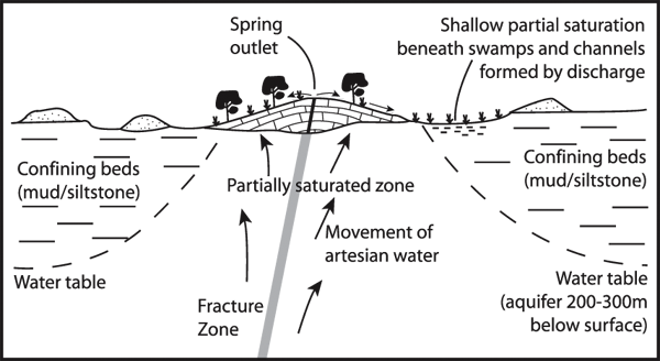
Cross section of a typical active mound spring, including associated swamp areas and aeolian deposits in the form of dunes (from Thomson and Barnett, 1985).
The character of mound springs across northeastern South Australia is variable. The Dalhousie Springs complex in the Simpson Desert represents 90% of total spring discharge for the Great Artesian Basin (Smith, 1989). Groundwater from the Dalhousie Springs is thought to have originated from recharge on the western margins of the basin rather than the Great Dividing Range (Krieg, 1989). Mound springs accumulate in clusters, and activity includes the formation and reworking of new mounds as the hydrologic regime dictates (Krieg, 1989). In comparison, the level of activity of the mound springs south of Lake Eyre has waned since the arrival of Europeans in the area (Harris, 1985). At Lakes Frome and Callabonna, mound springs are relatively small seepages occurring on the edges of the playas (Forbes, 1985). The composition of the mounds varies from carbonate dominated sediment to mainly clastic material trapped by moisture and algal growth (Draper and Jensen, 1976). Clearly the level of activity of mound springs depends on the hydrology of the groundwater system, as well as the structural controls.