The Flinders Ranges lie within the Adelaide Fold Belt, where Palaeoproterozoic to Mesoproterozoic cratonic basement is overlain by a thick sequence of Neoproterozoic to Cambrian rift sediments of the Adelaide Geosyncline (Paul et al. 1999). The sedimentary package along with the crystalline basement were deformed in the Late Cambrian – Early Ordovician (~500-490 Ma) Delamerian Orogeny. In the northern Flinders Ranges, basement is exposed as variably deformed and metamorphosed partly fault-bound inliers around Mt Painter and Mount Babbage (Coats & Blissett, 1971).
The Paleoproterozoic to Mesoproterozoic crystalline basement of the Flinders Ranges is of note in that the constituent granites and gneisses of the basement are characterized by extraordinary enrichments in heat producing elements, with heat production rates frequently in excess of 10 Wm-3 (Neumann et al., 2000). Heat flows within the Flinders Ranges average 90 mWm-2, with a high of 125 mW/m-2 in the Mount Painter region (Figure 5). The anomalous heat flows form part of a broader region of elevated heat-flow extending westwards into the eastern Gawler Craton (average heat flow 85 mWm-2) and eastwards into the Curnamona Craton (average heat flow ~75 mWm-2); values which are typical of much of the Australian Proterozoic crust (Cull, 1982; Houseman et al., 1989), and differ from the much lower heatflows of the western Gawler Craton and Archean cratons of Western Australia where heat flows typically lie in the range 35-55 mWm-2 (Cull, 1982). Neumann et al. (2000) and McLaren et al. (2003) show that the high heatflows in the Australian Proterozoic are invariably associated with anomalous heat production in the near surface crust.
Figure 1. Location map
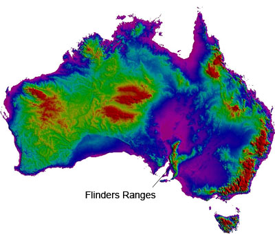
Map of the Australian continent showing the location of the Flinders Ranges, data courtesy of Geoscience Australia, compiled by Mike Sandiford.
Deposited on top of this crystaline basement is a 5-10 km thick Neoproterozoic sedimentary sequence (Paul et al., 1999), understood to have been deposited during an episode of major continental rifting (Preiss, 1987). Sedimentation ceased towards the end of the Cambrian (~520 Ma) with the initiation of a succession of inversion events, associated with the Delamerian Orogeny (Thomson, 1969) and the onset of plate convergence along the paleo-Pacific margin. In the Flinders Ranges, both the basement and cover sequences were deformed, with total shortening no more than ~15% (Paul et al., 1999).
A period of relative tectonic quiescence followed with mild thermal perturbations attributed to the late Palaeozoic Alice Springs Orogeny (Gibson and Stuwe, 2000; McLaren et al., 2002). Episodes of fluvial to lacustrine deposition occurred in the Cretaceous, Eocene and Miocene. Intermittent sedimentation in the mid-late Neogene is reflected in low-energy fluviatile and lacustrine sediments of the Namba Formation. On the pediments flanking the northern Flinders ranges, the Namba Formation is overlain by Pliocene to Quaternary gravels and fanglomerates of the Willawortina and Pooraka Formations (Callen, 1974).
The origin of the present-day relief of the Flinders Ranges has been the subject of varied opinion. The general lack of recognition of significant young tectonic activity has lead most workers to the view that the topography is ancient, extending back at least to the early Cenozoic (Veevers and Conaghan, 1984). ln the northern Flinders Ranges, several convincing lines of evidence point to the present-day topography being post Mesozoic. Firstly, distinctive summit surfaces locally overlain by Cretaceous fluvial sequences imply the present-day relief has been generated since the Mesozoic. Secondly, rangebounding alluvial fan sequences (Willawortina Formation) seem to have developed only in the late Neogene (Belperio, 1995) with older Late Miocene sequences (Namba Formation) reflecting low-energy, paralic conditions in the regions bordering the present ranges. Callen and Tedford (1976) argued that the transition from low-energy sediments of the Namba Formation to the alluvial fans of the Willawortina Formation in the late Miocene or Pliocene reflects the initiation of uplift of the Flinders Ranges. In recent times, this notion of youthful tectonic activity building the relief of the upland system has been further developed by Sandiford (2003) who has suggested as much as half of the present-day relief of the Mount Lofty Ranges is associated with late Neogene reverse-faulting, with Quaternary slip at rates locally as high as 50 m/myr.
The area east of the Flinders Ranges escarpment comprises a variety of Quaternary arid landscapes. Drainage from the northeastern Flinders ranges passes through a series of uplifted pediment surfaces and across a subdued alluvial plain to Lake Frome (Twidale and Bourne, 1996). The eastern edge of the alluvial plain is overlain by occasional longitudinal sand dunes, which comprise locally derived sediments and run east-northeast, reflecting the resultant vector of the sand shifting winds. A discontinuous palaeoshoreline lies several kilometers to the west of Lake Frome and is oriented approximately north-south, and parallel to the current lake shoreline.
Immediately east of Lake Frome lies the extensive dunefield of the southern Strzelecki Desert. The dunefield is dominated by both longitudinal and transverse dunes. The transverse dunes, oriented approximately north-south and parallel to the playa shoreline, are thought to represent ancient shorelines reflecting the past hydrological history of the region. Subsequent aridity and aeolian activity has resulted in the denudation of, as well as further aeolian deposition over, these features. Four transverse dunes have been clearly identified in the area northeast of Lake Frome. Longitudinal dunes, oriented in the same east-northeast direction as those to the west of the playa, extend perpendicular to and downwind of the transverse ridges, and dominate the landscape.
Both the longitudinal and transverse dunes retain an internal structure consisting of multiple palaeosols overlying undisturbed, laminated aeolian sediments. The development and preservation of these old soils is possible due to a clay component, which maintains structural integrity. The presence of clay in desert sand dunes is unusual (Wasson, 1983) and yields significant information about the environmental conditions responsible for their formation. In particular, it indicates the importance of changes in the level of the water table to enable the aeolian transportation of clays as pelletal aggregates (Bowler, 1973). This information, when coupled with chronological data (Wasson, 1983; Callen, 1984; Lomax et al., 2003), yields important insights into the late Quaternary evolution of arid landscapes in the Lake Eyre basin.