Mahadevan, T.M. 2003. 4D-modeling Of Indian Continental Evolution Through A Geophysical Window: Geological Constraints.
Journal of the Virtual Explorer 12, 1-29.
4D-modeling Of Indian Continental Evolution Through A Geophysical Window: Geological Constraints.
Abstract
Abstract: The paper discusses the contrasting trends in the Precambrian and Phanerozoic evolution of two regions in the southern (region I) and the central parts of the Indian shield (Region II) selected on the basis of the relatively richer geological and geophysical database available. Both regions span two or three orogenies during the whole of the Late Archaean and the Proterozoic and region II has witnessed major thermal episodes of the Late Mesozoic. Current models of tectonics based on empirical considerations of converging reflections or a bi-modal gravity feature, not specifically related to time but based on broad concepts of principles of uniformitarianism, are simplistic and ignore the multi-genetic possibilities of geophysical signatures in a poly-orogenic setting.
Region I had a dichronous evolution, wherein the exhumed high-grade domain was a distinct open system that intimately interacted with the magmatic and thermal evolution of the mantle through the whole of the Precambrian. The region II, however, lacks the polarity of a distinctive Proterozoic high-grade domain and exposes dominantly low to mid-crustal greenschist- amphibolite facies regimes with bands of exhumed granulite facies rocks. Shallower crustal segments preserve near surface distensional basinal structures (such as the Vindhyan and Gondwana basins) overprinted penetratively by Phanerozoic Rajamahal and Deccan basic – alkaline magmatism. The broad sequence of Proterozoic tectonics in the shield is one of inversion of rifted basins of one period in a single large Archaean continent becoming centers of compression and opening up of neighbouring extensional domains due to migration of the mantle thermal regime. The contrasting trends of evolution of the two terrains may be related to the varying thermal regimes in the mantle within a single continental plate and the differing styles of interaction perhaps initiated even in the Archaean. The complex inversion tectonics in this context needs careful evaluation taking into consideration space-time variations in the thermal impacts on the different continental segments.
Introduction
Of great interest to earth sciences in terms of fundamental aspects of lithospheric and mantle evolution is unraveling the deep continental structure and composition through time using several geological, geochemical and geophysical parameters. The lithosphere and, perhaps, even the mantle may be expected to carry memories of past evolution; but identifying or separating out especially geophysical memories in a time sequence is difficult, as there is no stamp of time in any geophysical signal. The problem is compounded by the fact that different methods address different physical or chemical properties and, therefore, the results flowing from them may not or need not be strictly comparable; the ambiguity attached to sources of geophysical signals as, for example, crustal reflectivity or electrical conductivity and thirdly by unevenness of data across areas that are correlated or paucity of data due to thick younger cover of formations. A fact often ignored in comparisons of geophysical features and relating them to genetic models, is that same or similar geophysical characteristics can be imposed on the rocks by more than one geological process. An outstanding example from the Indian shield very relevant to this paper is the very basis of characterising the crustal layers as “Upper” and “Lower crust”. These terms are not merely adjectives but designate specific layers in the crust with characteristic properties. Such a designation is rendered meaningless when rocks evolved in the Lower Crust are exhumed to shallower depths under poly-baric but isothermal conditions and tend to become deformed and recrystallised and lighter due to development of hydrous minerals. They thereby have densities and a seismic velocity structure falling within the normative range of velocities and densities for the “Upper Crust”. They may continue to be reflective or may lose their reflectivity. Seismic velocities in such rocks, however, may not be lower than 6.2 km/sec and may, perhaps, never reach a level of 5.8 km/sec This could, then, be a constraint in interpreting velocity data in regions of large-scale exhumation of the Lower or middle crust. Characterising these rocks as “Upper Crustal” rocks just because they are now close to the surface and a lower P-wave velocity than a typical “Lower Crust” may be misleading.
A limitation that can render geological maps unrepresentative is the paucity of outcrops in vast stretches of a region, like Rajasthan, even as younger cover of Gondwanas and Deccan basalt flows masks very effectively the Precambrian basement in Central and Western India. Thus, for example, the extent of exhumation of the Lower Crustal rocks in the Rajasthan or the Central Indian shield is rendered uncertain due to vast younger cover. The above limitations render almost all modeling very tentative and underline the need to constrain geophysical modeling necessarily through integration of several sources of information on major events of crustal evolution as deduced from geology and geochronology. Some speculation in this regard seems inevitable and renders interpretations non-unique and challenging.
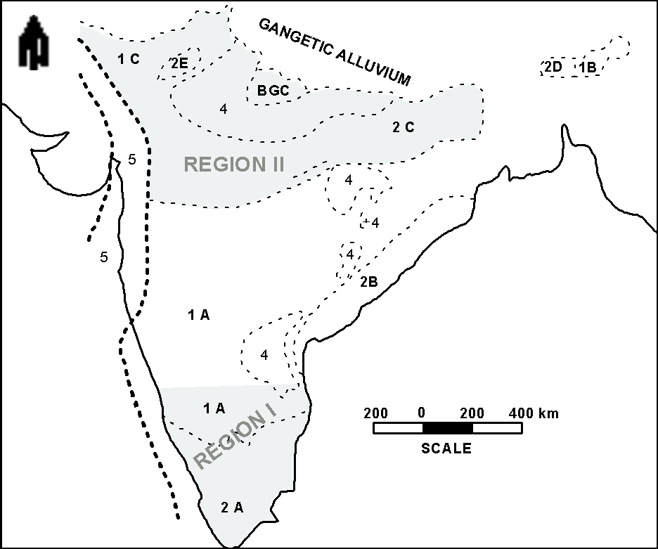
An attempt is made in this paper to review the distinctive patterns of evolution in the Archaean through the Proterozoic and the Phanerozoic of two distinctive geological provinces of the Indian Precambrian shield, taking into consideration several sources of information. The regions selected include the south Indian Shield south of Lat.20oN comprising the (i) the Archaean Karnataka craton and the high-grade dominantly Proterozoic high- grade domain, fringing the former on the south (herein referred to as Region I) and (ii) the Aravalli - Central Indian region occurring north and NW of the CCR with a distinctive Precambrian evolution overprinted by episodes of late Mesozoic volcanism (herein referred to as Region II). These regions are selected as they have attracted much attention from earth scientists in recent times, and therefore have a good, though not uniform, database in terms of geological, geochronological, geophysical and geochemical parameters. (Figure 1). Data from the Chotanagpur Region in the east and the Cambay basin in the west are briefly referred to for generating a comprehensive discussion.
Geological Framework
The geological setting of the regions I and II are to be seen in the context of the complex geological setting of the Indian shield as a whole. They are located respectively along the southern and N and NW borders of a central cratonic region (CCR), that was evolved mainly in the late Archaean to early Proterozoic. The central cratonic region dominantly comprising granitic gneisses, often designated as “Peninsular Gneiss” and associated with several linear to oblong volcano-sedimentary sequences, some dominantly ensimatic and others ensialic. The more ensimatic among the supracrustals have been also characterized as “greenstone belts”. The granitoids have a plutonic aspect while the volcano-sedimentary sequences have evolved in shallow depths and are, therefore, often called the supracrustals. These supracrustals are metamorphosed over large tracts to generally the green-schist to the lower amphibolite metamorphic facies but remain lowly metamorphosed. over large tracts, as for example in Western Karnataka. The basement cover relationship between the “supracrustals” and the Peninsular Gneisses is rather complex, features of unconformable superposition in some areas giving place to intrusive contacts at others, raising questions about the polychronous nature of both the supracrustals and the basement Peninsular Gneisses. An important characteristic of the Precambrian shield is the close association of high- grade rocks (upper amphibolite to granulite facies) with the Peninsular Gneiss, including amidst them the well known charnockite-khondalite group of rocks evolved in the middle- to lower crust. (Figure 2) More than one generation of charnockites are now inferred but their mid-to lower crustal home of formation is established by the P-T conditions of the metamorphic mineral paragenesis. As these rocks are transformed during exhumation, the isotopic clocks are reset and therefore the isotopic ages determined constrain the time of exhumation and accompanying transformations from depths of their formation, which determine the degree of effective resetting of the isotopic clocks
The regions selected have major geological differences. In region I, the low-grade Archaean-Proterozoic cratonic block shows well-developed Archaean greenstone belts many of which preserve several of the pristine characteristics of the igneous and sedimentary components, being very lowly metamorphosed, as for example in the western Dharwar supracrustals. There is a definable boundary with the largely Proterozoic high-grade domain in the south, the tortuous Fermor line that also has been designated as the ortho-pyroxene isograd. In region II the plurality of such a distinctive distribution is lacking and the high-grade rocks do not form a large domain but instead are exposed in narrow more or less structurally concordant belts or small zones. The greenstone belts are also not well preserved and some suspected greenstone belts like the Hindoli group in Rajasthan or the Mahakoshal group of Central India have been involved in penetrative tectonics and have been much metamorphosed and do not retain the pristine features so well recognized in the Dharwars of Karnataka. The orogenic/ thermal imprints in the Aravalli-Delhi fold belt of region II continued well into the mid- to late Proterozoic, overprinting the whole of the region.. Another important difference is the large incidence in region I of both Archaean and Proterozoic generations of ultrabasic- basic and alkaline plutonites, like anorthosites and gabbros, alkaline basic rocks, syenites and granites, all of which are generally believed to be generated by the partial melting of the mantle rocks or the lower crustal rocks, in especially granitic melts. The high incidence of these rocks in the south Indian shield and the Eastern Ghat Mobile Belt (area not considered here due to paucity of geophysical data) is due to continued high thermal gradients arising primarily from a hot mantle and secondly the level of exhumation has extended down to the LC deeper down closer to the mantle. There is a low incidence of these plutonites in the region II. This may be due to their non-emplacement in the crust or the fact that the levels of the earth’s crust exposed are too shallow to expose plutonites that may be expected to rest in the deeper levels of the crust by virtue of their greater densities.
Region II is directly involved in Phanerozoic events such as the Gondwana crustal distensions and basin development and the two generations of continental basalt magmatism, the Rajmahal and Deccan. Tectonically these events are extensional and therefore can effect changes in the relative thickness of the UC and LC and even the depth to the Moho, depending on the degrees of distension. The onset of large Phanerozoic magmatic events may be pre- determined by their rather distinctive style of Precambrian evolution and the potential of the mantle below for frequent thermal reactivation. These are, however, speculations that need careful consideration but provide a broader perspective inter-relating the crustal history to the thermal evolution of the mantle, an important dimension, ignored in tectonic modeling.
The differences in the geological settings of the two regions outlined above are reflected in a distinctive deep continental structure and in several geophysical parameters. This paper attempts to chronicle the different stages of tectonic evolution of the two regions and discuss some constraints on the evolutionary history set by the geophysical features that characterize these ancient continental segments.
South Indian Shield (Region I ).
The south Indian shield provides an oblique cross- section across the Indian continental crust (Fermor in Pascoe, 1954; Fountain and Salisbury, 1981) and is one the most extensive of exhumed lower crustal rocks in the world, emerging from below the greenstone-granite domain of the Karnataka craton in the north. The extensive regional exposures of charnockitic rocks preserve the metamorphic imprint of the L C. and enclaves with more ancient protolithic ages than the host rocks that give a clue to their Archaean ancestry. Subsequent evolution in especially the Late Archaean and the Proterozoic is punctuated with several episodes of ultrabasic, basic and alkaline magmatism, with which is associated, though on a smaller scale, the formation of more than one generation of charnockites (granulites) (Santosh, 1989), some even from mid- to lower crust under high partial pressures of CO2 lowering the p (H2O) (Table1).
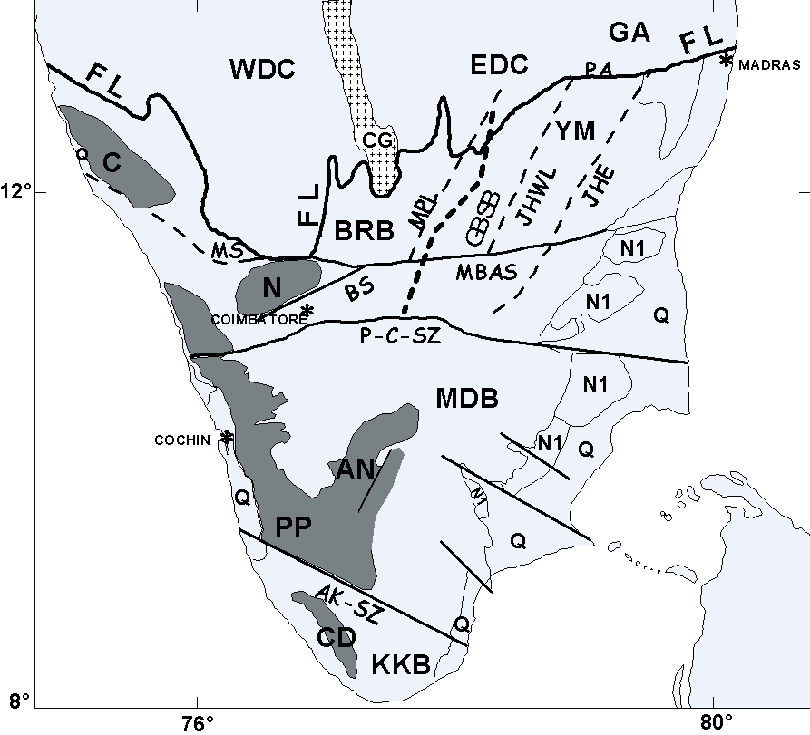
The HGD of south Indian shield may be divided into number sub-domains that are separated by near vertical faults or shear zones. The sub-domains include the (i) the Biligirangan block (BRB); (ii) the Nilgiri Block, (iii) the NE- SW trending highly faulted Dharmapuri rift extending from Vaniyambadi in the NE to Bhavani in the SE and (iv) the Palghat-Cauvery belt of faults, a rift zone, between Bhavani and Palani; (v) the Kodaikanal- Anamalai- Madurai block and (vi) the Kerala Block. The major bounding faults/shear zones include the Moyar shear zone that separates the Nilgiri Block from the Karnataka block; the Bhavani fault that separates the Nilgiri Block from the Palghat- Cauvery rift zone on its south; the eastward extension of the Moyar-Bhavani faults into possibly the Attur fault and the Thenmalai- Achenkovil shear zones that separate the Madura block from the Kerala block. (Figure. 3).
The tectonic setting of the HGD of South India has been viewed by several workers as one of micro-continents sutured along the Palghat-Cauvery and Achenkoil shear zones on mainly lithological contrasts across these fault zones and geochronological data that, however, seem to ignore possibilities of resetting of ages through progressively younger granitic magmatism southwards. However, unequivocal tectonic and petrotectonic evidence for a suture is lacking. . If we assign the khondalite suite of sediments a supracrustal status and the protoliths of the charnockite a basement status, it will be evident that the different blocks of the shield are at different crustal levels and have differential uplifts along the bounding faults.
The Dharmapuri and the Palghat-Cauvery rift zones are characterised by 2 or 3 generations of ultrabasic, basic, alkaline and calc-alkaline plutonites spanning the time band of 2500 to 550 Ma, standing testimony to the overprinting of the transtensional regimes over an earlier compressional regime. Alkaline rocks, syenites and carbonatites are also found along the NE-SW trending Kambam valley in the Madurai bloc (Figures 2 and 3).(Subramanian and Selvan, 2001).
Varying paleodepths of burial have been estimated based on several mineral pairs; 4 kbar (= ~12 km palaeodepth) in the GGD of in the Karnataka Craton; 9 kbar (= 27- 30 km palaeodepth) in the Nilgiri Mountains and in the Biligirirangan, 8 kbar (24 to 27km palaeodepth) in the Madurai Block in an early phase followed by a 4.5 kbar (14 to 16km palaeodepth) and 700C and 4.5 to 6 kbar in the temperature range of (700-750°C) in the KKB. These may be taken to indicate the minimum depths of burial registered in the metamorphic history of each terrain, from which the rocks have been exhumed and uplifted to the present levels of their exposure through P-T-t paths. The P-T-t paths have a dominant isothermal decompressive history (ITD), (cf.Jayananda and Peucat, 1996; Anand Mohan and Jayananda, 1999;Harris et al.., 1982), within a framework of complex isobaric and isothermal stages, each of which may have been episodic and dominant in one region or the other.
“Ultra-high density” primary inclusions of CO2 (1.172 – 1.1555 gm/cc) are reported in garnets in a granulite near Salem and are traced to fluids exsolved from mantle magmas or to CO2 transfer from the mantle through deep rooted shear system ( Santosh and Tsunogae, 2003) and also in granulites of Biligirirangan Hills , the Moyar- Bhavani shear zones and Chennimalai and Dharapuram in the Madurai block. (Srikantappa et al, 2003). High density CO2 (1.15g/cc) is also associated with the Eastern Ghat granulite belt involved in ultra-high temperature metamorphism (Sarkar et al., 2003). The ultra-high density CO2 inclusions have a mantle connection (Santosh and Tsunogae, 2003; Santosh, 2003).
A large amount of Sm-Nd, Rb-Sr and U-Pb isotopic data have been generated that point to 4 different age provinces (Baskar Rao, et al., 2003), namely (i) the BR block of mid- Archaean protoliths; (ii) the Nilgiri massif with protolith ages of 2.7 Ga; (iii) the Cauveri-Noyil- shear zone of 3.2 to 2.7 Ga ages; (iv) the belt of Kodaikanal-Oddanchatram block of 2.7 – 1.7 – 0.5 Ga ages A synthesis of the available Sm-Nd, Rb-Sr and U-Pb isotope systematics point to (i) protolith ages of ~3.0 to 2.8 Ga overprinted by the younger ages of 2.5 ±0.4 Ga dominantly in the Dharwar craton and the Dharmapuri belt and (ii) ages of ~ 750 - 550 ma in the Dharmapuri and Palghat - Cauvery belts. The region further south, in the Madurai and Kerala blocks has a dominant overprinting by ~550 ma ages. Older protolith ages of 2.7 Ga are noted in the Madurai block but no ages older than the Pan-African event (750 –550 Ma) dominates in the Kerala Block (See Figures 3 and 5 in Bhaskara Rao et al., 2003).
A parallel contribution by Santosh et al. (2003) reporting age data on zircons, monazite, uraninite and huttonite from some 29 rock suites drawn from a variety of common litho units in the southern granulite terrain supports the above findings. Zircons from the terrain north of the Palghat-Cauvery shear zone register ages as old as 3.3-2.6–2.4 Ga. In the Madurai block to the south of the PCSZ ages of 1.7-0.82-0.58 Ga are registered while in the Trivandrum- Nagerkoil block ages of 2.0- 1.7, 1.0-0.8 are registered along with a more dominant overprinting of 0.55 Ga ages.
From the differential exhumation of the different blocks and the migrating thermal events from the older blocks in the north southwards spanning the whole of the Proterozoic, it seems likely that the HGD constitutes a part of one Archaean continent that witnessed a thermal regeneration progressively through Proterozoic. The different isotopic ages have to be viewed in this context. Further the mantle below the HGD is an enriched mantle and therefore geochronological models based on depleted mantle composition may have much hidden meaning in them than what is realized.
It is now necessary to look at the geophysical features of the HGD and see how best they could be explained in terms of the episodes of evolution registered in the geological record.
Geophysical Characteristics.
Magnetic Fields
Modeling of aeromagnetic data south of 12oN latitude reveals that the magnetic crust in the south Indian HGD is a composite of different blocks separated by vertical faults. The magnetic basement in the different blocks is variable and extends down to depths of 16 to 24 km. below the msl (Reddy, A.G.B. et al., 1988). A similar conclusion has been arrived at by more recent work by Mita Rajaram et al., (2003). They conclude that the crust below the HGD is distinctive, as the crust below 22 kms does not contribute significantly to the magnetic anomalies. In contrast, the crust below the Dharwar craton is magnetic over its entire thickness. The distinctive below HGD may be either due to compositional changes or Curie isotherm destroying the magnetic field. Interestingly the magnetic crustal layering generally coincides with the LVL established in seismic profiles described below, and, therefore, supports the possibility of a compositional change, possibly a transformed LC under the impact of several magmatic and hydrothermal events. (Mahadevan, 2003 b).
Gravity Field
The Bouguer gravity field of the South Indian shield is strongly negative in relation to the northern parts of the shield. (Figure 5), implying a lighter lithosphere as a whole. Other contributory factors for a negative Bouguer field may include a combination of the influence of the strong Indian Ocean gravity low, south of Kanyakumari (southern tip of the shield); the presence of thick belts of supracrustals and the presence of large granitic and syenitic bodies.
Transect Data
Recently completed multidisciplinary studies along the Kuppam-Palani transect have brought out several interesting characteristics of the deep crust along the two rift zones, the Dharmapuri rift zone and the Palghat- Cauvery rift zone. The structure may be true of only these two intracontinental trans-tension belts and may not be representative of the whole of the HGD. The main characteristics of these include the following.
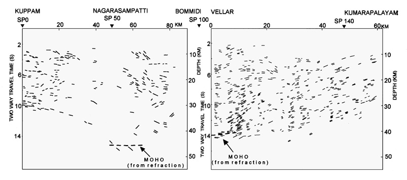
(i) A four-layered velocity structure with average P- wave velocities of 6.10- 6.30; 6.50 –6.60; 5.90- 6.05 and 6.90 – 7.10 from top to bottom There is a prominent mid- crustal 7-15 km thick low velocity zone of 5.9 to 6.05 km-sec P- wave velocity. (LVZ) (at a depth of ~ 20km), (Figure 6 a, b). The 1-D velocity-depth models are shown in Figure 6c. The depth to the MOHO ranges from 41 to 45 km with local up warps and, therefore, points to a thickened crust, subsequently deformed.
(ii) The crust is highly reflective below ~10km from the surface and the reflective layers show some reversals in dip giving rise to regional convergence, apart from being domical on a smaller scale. (Figure 7a and b). The base of the reflective crust coincides with the refraction MOHO wherever located and together they indicate a variable thickness for the crust. Further the lack of a consistent refraction MOHO and the presence of some reflectors from below the refraction Moho are suggestive of a transitional MOHO (Mahadevan, 2003), possibly a transformed mantle resulting from repeated partial melting. More seismic data from the subcrustal lithosphere is needed to confirm these possibilities.
(iii) Magnetic and gravity modeling confirm the 4-layer velocity structure and based on bi-modal anomalies have been interpreted along lines of collision models (Singh, A. P et al., 2003).
(iv) A general correspondence is observed, though with some exceptions, in the order of electrical conductivity with the LVZ of high electrical conductivity. Resistivity at depth is strongly influenced by the deep faults in the region that result from crustal fracturing and fluid migration. The distribution of resistivity pattern is complex and resistivity contrasts have been noticed on either side of the Palghat- Cauvery Shear Zone.
(v) Heat flow measurements in specially prepared boreholes drilled in the block north of the Palghat-Cauvery rift zone works out to 36 ±4 (SD) mWm-2 and for the block south of it 44 ± 6 (SD) mWm-2. Based on measured values of heat generation, it is inferred that the heat-flow from the mantle would be 26- 29 mWm-2. In contrast the heat-flow from the mantle below the Dharwar craton is estimated at 12-19 mWm-2. These results are consistent with an enriched mantle underlying the SGT, possibly generated by post-Archaean (early Proterozoic to Pan African) mantle metasomatism. (Roy et al.,2003). The mantle may also be enriched in CO2 (or minerals with CO3 molecules) and (OH) molecules that then make it lighter.
Seismic tomography models
Seismic tomography of the region south of lat. 15oN, established deep tectospheric roots below the south Indian shield, extending down to greater than, debatably, 150 to 400 km (Iyer et al., 1989; Polet and Anderson, 1995). The crust (0-40km) below the western Dharwar craton and the HGD have lower velocities compared to the higher velocities below the Eastern Dharwar and that the upper mantle in the depth range of 40-177 km is characterized by lower velocities beneath the HGD compared to the western Dharwar craton. The mantle is more homogeneous below the 177 km depth (Srinagesh and Rai, 1996). In contrast the lithosphere below the Central Indian region (CIR) and the western margin of the shield is estimated, based on surface wave investigations, to be ~ 100km based on gravity and surface waves (Singh, DD, 1991). According to these models, therefore, a deepening of the lithosphere roots from central India into the south Indian shield may be envisaged. Further, the sequential evolution of the Archaean Dharwar Craton and the South Indian HGDs implies that the cratonisation (lowering of the thermal boundary of the lithosphere) of the South Indian Craton as a whole to depths of >250 km may also have been achieved sequentially during the Archaean through the Early to Middle Proterozoic. Recent tomographic studies by Kennet and Widiyantoro (1999), however, suggest a low velocity column in the whole of the south Indian shield down to depths of 250 km and a relatively narrow band of high velocity thick lithosphere in the central Indian region that extends into central and western Himalaya. (This is referred to here as the K-W model). These results are not wholly in keeping with the earlier results reported above, for the southern shield. However, they are consistent with a lighter lithosphere, which is experiencing exhumation. Significantly the K-W model implies vestiges of a deepened lithosphere in Central Indian region. The implications of these are discussed later.
Phanerozoic evolution
The deep-rooted Dharwar-HGD continental lithosphere, seems to have remained quite stable till late in the Mesozoic. The impact of the Rajmahal Volcanism of early Cretaceous and the accompanying rifting along the eastern margins of the Indian Shield is less evident on the features of the Southern Indian Shield. The rifting and accompanying Deccan continental basalt magmatism had a profound impact on the shield and led possibly to magmatic under plating resulting in crustal uplift on the west and a tilt eastwards. This event has resulted in the emplacement of basic dyke clusters in the western part of the South Indian shield. The easterly tilt has, however, contributed to the uplift of the lower and mid- crust and the dominant exposures of high grade rocks along the pericontinental margins.
The thermal impact of the mantle on a major part of the western half of the shield seems to be an ongoing process resulting in the continuing uplift of the Nilgiri and Anamalai Plateaux. A probable mechanism of such uplift is the chemical assimilation along the base of the mantle or what may be termed as erosion of the lithosphere base by the mantle processes, Such erosion may generate an isostatic response of uplift. Where the erosion is differential, the resulting uplift is variable. The process is intrinsically slow and the uplift rates are slow. These processes have an obvious impact on the geomorphology of the region and on many geophysical characteristics.
Geophysical features and Crustal Evolution
The Geophysical features discussed along the transect are typically those of two intracontinental rift zones, the Dharmapuri rift and the Palghat Cauvery rift, that were the sites of several episodic phases of ultrabasic, basic, alkaline and granitic magmatism in the span of some 2000 million years of the Proterozoic (~ 2500-500 Ma). The seismic velocity structure may not represent the continental structure away from the intracontinental rifts, as for example below the great charnockitic massifs. The rift zones are characterised by inversion tectonics with several phases of compressional and extentional tectonics, which remain poorly defined. The Proterozoic regime was expressed in an episodic extensional isothermal decompression that governed the differential exhumation paths of several large massifs of Lower Crustal (charnockitic) rocks and was punctuated by the episodes of magmatism. The HGD of the southern shield has been a system totally open to the magmatic and fluid influx from the thermal regime of the asthenosphere. A negative buoyancy thereby imposed may have been the driving force for the exhumation of the LC on a continental scale. Reflectivity and the mid-crustal low velocity layers seem to be the characteristic features derived from the extensional episodes and the mineralogical transformations in the isothermal exhumation of the LC. The structure of the magmatic plutonites may also contribute to some of the elements in the reflective crustal fabric, rather than collision. The relatively thinner magnetic crust (~22km) in the shield and its coincidence with the mid-crustal LVL are suggestive of a crustal transformation by the impact of the several episodes of magmatism and hydrothermal activity. The Mettur fault chosen as the site of an earlier collision by Reddy et al. (2003) is one of the bounding faults of the NE-SW trending Dharmapuri rift zone. It is possible that the rifts themselves are part of a supra-subduction environment but then considering the NE-SW trend of the Dharmapuri rift zone and the E-W trend of the Palghat-Cauvery rift zone, the transpression leading to subduction and collision should be away from the zone.
The geophysical features of the south Indian shield has to be viewed against not only the Proterozoic but also the ongoing Phanerozoic extensional tectonics and the uplift of the western margins of the shield and the on going uplift of segments like the Sahyadri and Malayadri Mountains. In this regard the seismic structures may retain Precambrian memories more than the potential fields that may be expected to be more sensitive to change. Electrical conductivity due to thermally charged fluids has to be related to even on-going or recent events, and they cannot be tied to Precambrian memories.The magmatic underplating associated with the West Coast rifting in the Mesozoic associated with Deccan basalt magmatism and the consequent eastward tilt of the Shield are major events that must be addressed while modeling the gravity fields and in modeling mid-crustal electrical conductivity. The latter , if due to fluids, is likely tobe due to more recent , or perhaps, on-going lithosphere- mantle interactions.
NW Indian Shield -Region II.
The Region II (Figure 8) may be grouped into the following three sub provinces on tectono-lithostratigraphic considerations.
(i) The Aravalli-Delhi Tectonic belt (ADTB)
(ii) The Bundelkhand Granitic Gneiss complex (BGGC);
and
(iii) The Central Indian region
The Geological formations in these three blocks are compared in Table II. with those of the Chotanagpur Plateau in the east and the Southern Indian shield. The formations are grouped on the basis of field relations reported and the available geochronological data and grouping is tentative.
Aravalli-Delhi Tectonic Belt (ADTB).
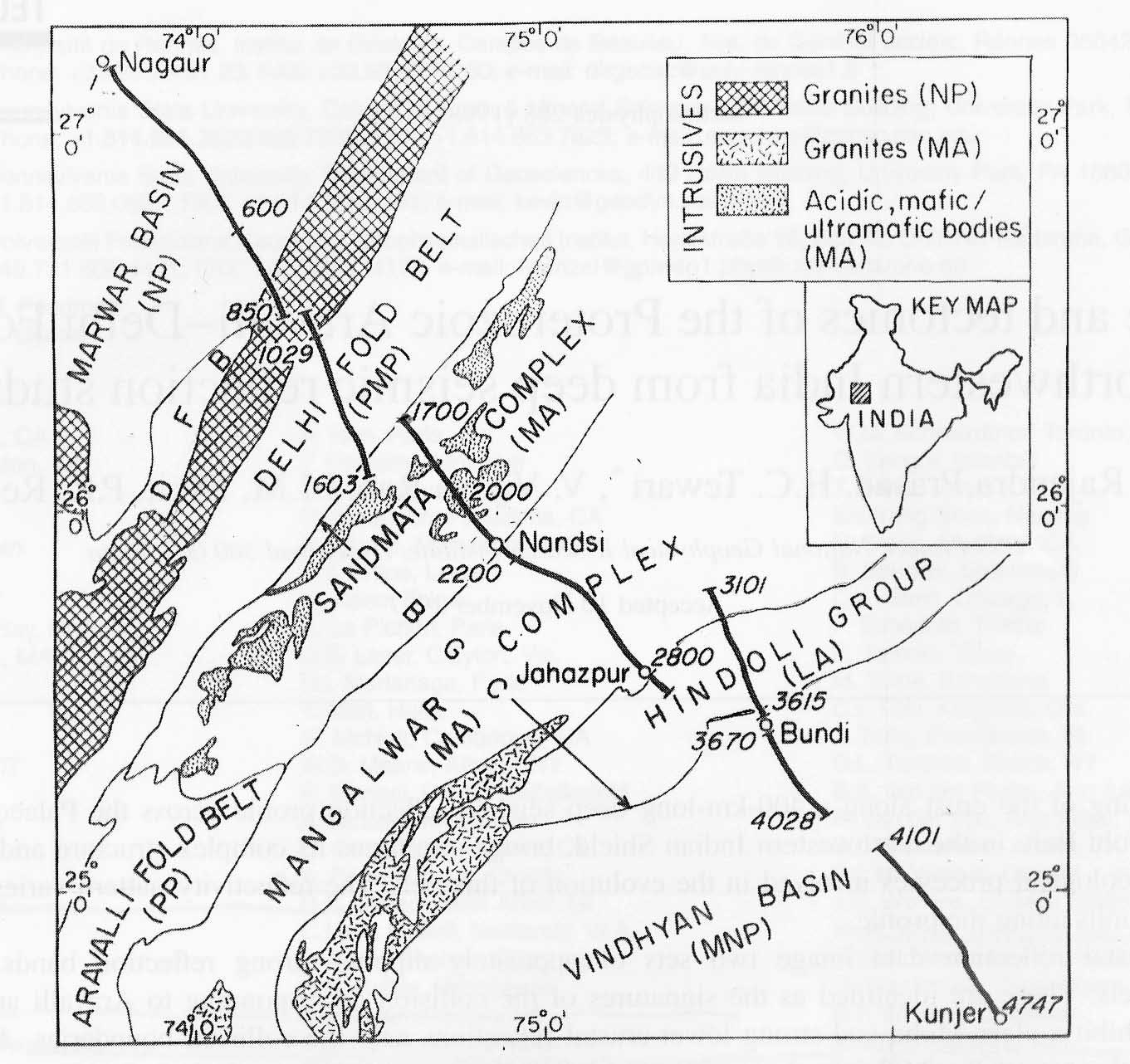
The Precambrian geological evolution of the Rajasthan region is distinctive from that of the southern Indian shield as is evident from the absence of the spatial polarity between Archaean greenstone –granite domain and the HGD domain so characteristic of the south Indian shield. Instead of separating out into two distinctive diachronous blocks as in the southern shield, the region evolved as a whole, overprinted by more than one major orogenic cycle all of which have been more or less penetrative through the entire Precambrian crust of Rajasthan. The Archaean Banded Gneissic Complex (BGC), Paleoproterozoic Aravalli belt and the Mesoproterozoic Delhi belt represent these orogenic cycles. Whether the Aravalli and Delhi orogenies were two separate events or the Delhi orogeny is a continuation of the Aravalli over a restricted region may be debated (eg.Sharma, 1995). The formations related to these orogenies overlie the BGC that forms the basement complex and cradle between the unmetamorphosed platformal Meso / Neoproterozoic Vindhyan Basin (VB) in the east and the Neoproterozoic Marwar Basin (MB) in the west. (Figure 9). (see Roy, A.B,1988 for a comprehensive review).
More recent studies suggest that the Bundelkhand granitic complex and the BGC may have been one continuous protocontinental basement for the Proterozoic sequences (Mondal et al., 2002).
Belts of high-grade rocks of the granulite facies are restricted to large exposures of charnockitic rocks in the Sandmata Complex on the eastern flanks of the Delhi fold belt and the Ramgarh area further south (Khandelwal and Pandya, 1988; Desai et al., 1979). They also occur in association with layered pyroxenite-anorthosite sequence in the Mt.Abu - Balaram area in the SW margin of the Aravalli-Delhi fold belt and in the Pilwa-Chinwal area on the NW margin of the DFB as part of the Anasagar Migmatite complex (Raja Rao et al., 1971; Desai et al., 1978; Fareeduddin,2000). The latter may be falling in a strike along which further search may reveal charnockitic rocks under the cover of aeolian sands. These are possibly part of the Archaean BGC, which has been transformed through exhumation to higher crustal levels with accompanying granitic magmatism. Several Proterozoic ages cited for these granulites, including those of zircons may be reset ages during several episodes of acid magmatism the region has undergone.
The P-T-t paths of the Sandmata Complex are inferred from a mineral assemblage that stabilized at 650-850oC and 8-11 kb pressure, suggestive of a minimum burial of, say, 20 km from which it was exhumed to shallow crustal levels. Sharma (1988) suggests an early anticlockwise prograde path followed by near-isothermal exhumation to 5kb level and 600o C temperature. Sharma suggests a non-collision setting compatible with some magmatic underplating. The subsequent uplift of the Complex may be due to distension events in the Proterozoic. The Sandmata Complex granulites are dated 1600 Ma and considering the fact this is the age of their transformed state, this age may fix a stage in the exhumation of the Sandmata Complex. It may be relevant to point out that the basement of the Vindhyans in the SONATA belt of Central India could have possibly been the exhumed charnockitic rocks (as discussed later here) and if the Vindhyans are older than 1100 Ma, as fixed by the kimberlite intrusives into the Semri group of the Vindhyans, then the exhumation of what are the basement may be older (>1100 Ma). The phase of uplift from the depths of 5kb to the surface may have been aided by the distension associated with rifting and formation of the Vindhyan basin. The time span of 1600 to 1100 Ma fixed by the above dates then imply that the exhumation of the LC in Rajasthan was an event contemporaneous with the Delhi Orogeny or more possibly may have heralded the formation of the Delhi basin. The formation of the Delhi basin may itself be related to the history of the exhumation of the lower crust. (see under transect data presented later).
The Anasagar Migmatite complex of which the Pilwa- Chinwal charnockites are a part have Sm-Nd ages of ~2800Ma and Rb-Sr age of 1600 Ma. Some younger ages have been yielded from zircon crystals. Though Fareeduddin (2000) assigns these granulite an younger age than the Sandmata Complex , the possibility of their being part of the Archaean BGC cannot be ruled out. The charnockites in other parts of Rajasthan are not dated and a common presumption is that they could have been part of the exhumed Archaean basement.
The orogenic evolution of the Rajasthan region is punctuated by repeated ultrabasic ,basic and acid magmatism. The acid magmatism is prominently manifested in the tonalitic/trondhjemitic palaeoliths (3.0Ga) in the BGC; Berach granites (2.9-2.5 Ga), Darwal and Amet granites (2.0-1.9 Ga); Ajmer-Alwar granites (1.7-1.5 Ga); Kishangarh syenite (1.5 Ga) and Erinpura granite (~850 Ma) magmatism, culminating in the Malani Igneous Suite (~780- 680 Ma) (Table II). The western fringes of the Delhi Fold belt also experienced the impact of the Pan- African thermal events and the mafic and alkaline magmatic activity associated with the Deccan magmatism of the late Mesozoic. A notable episode of basic magmatism along the western margin of the DFB at Phulad is a complex of metabasics, often named the “Phulad ophiolites” and cited as evidence of collision tectonics. These comprise transitional to mildly alkaline basalts associated with calciccarbonatites and fenitic rocks, emplaced in what may have been a rift environment (extensional tectonics), that may or may not have been induced by deep plume above the asthenosphere (Bose,1998). Bose, however, suggests that such an extensional environment may be part of a suprasubduction zone. The Phulad metabasics do not appear to be true ophiolites.
There are suggestions in the distribution of the episodic acid magmatic rocks and their geochronology that there has been a shift westwards from the Aravalli region into the Marwar region through the middle to Neoproterozoic culminating in the Malani igneous episode and a dominant Neoproterozoic evolution for the Marwar Block, compared to the earlier span of time of evolution of the DFB (1600- 800Ma). The Siwana-Jalor bi-modal magmatism that characterizes the Marwar Block is of a with-in plate, A-type (Kochhar,1998) and the tectonics of emplacement has been extensional (Pareek, 1981A &B). Such an environment has been obviously dictated by a migration of the thermal regime of the asthenosphere. A back-arc rifting in an island arc setting has also been suggested by some workers.
The westward shift of alkaline magnetism into the Marwar region has a parallel in the shift of Proterozoic granitic magmatism in the southern shield from the Karnataka craton to the Dharmapuri rift zone and then to the Madura-Kerala block. If the features presented by the exhumed and exposed LC in southern Indian shield are a guide, one may expect extensive transformations in the LC due to these magmatic episodes and the tectonics associated with their emplacement, that would then over- write the Lower Crustal geophysical signatures, make the LC more buoyant and capable of exhumation.
The Aravalli-Delhi fold belt has an active tectonic interface with the Cambay province in the west, a late Mesozoic rift associated with early alkaline and later tholeiitic phases of the Deccan continental basalt volcanism. The region has, therefore, been the foci of emplacement of alkaline plutons, like the Mer-Mundwara pluton and some carbonatite bodies. Large and extensive Deccan basalt flows and dykes also cover a large part of southern Rajasthan.
It is noteworthy that, taking a spatial view, the dominance of extensional alkaline magmatism in the Marwar Block in the western margins of the NW Indian shield and a similar dominance in the western margin of the south Indian Shield in the Madura-Kerala block, both in the Neoproterozoic, are suggestive of a Precambrian ancestry for the West Coast extensional faulting in the late Mesozoic (Mahadevan, 1998).
Gravity Field
In contrast to the southern shield, the gravity fields in the Aravalli and central Indian regions are more positive (Figure 5), consistent with a contrasting deep crustal structure and distinctive geological history. The causative regional factors that may account for the high Bouguer anomalies is a combination of both the Precambrian and Phanerozoic evolution, which together seem to have rendered the lithosphere in this region, on the whole, denser, giving rise to the positive Bouguer anomalies.
Transect Data
The results of the recent seismic, gravity, magnetic and magneto-telluric studies along the Nagaur-Jhalawar (N-J) transect of the Proterozoic Aravalli Delhi Fold Belt region in the NW Indian shield have significantly enhanced our understanding of the deep continental crust (Tewari et al., 1997a,b and 1999; Vijaya Rao et al., 2000; and Rajendra Prasad et al., 1998). The transect runs across the Neoproterozoic Marwar Basin (MB) in the NW, Palaeo-MesoProterozoic Delhi Fold belt (DFB), the Middle Archaean Sandmata Complex (SC), an ensemble of granulites and gneisses of the Bhilwara Gneissic Complex (BGC) the Middle Archaean Mangalwar Complex (MC) and the Late Archaean Hindoli Group (HG), both of which are suspected greenstone belts and finally the Meso- Neoproterozoic Vindhyan basin (VB) in the SE.(Figure 9) The only reliable velocity data along the profile is that obtained between Ren and Masuda in the DFB by refraction The crust has velocities of 5.75 km/sec; 6.2 km/sec, 5.8 km/sec and 6.60 km/sec rising to 7.3km/ sec followed by a upper mantle boundary velocity of 8.40 km/sec (Figure 10 a&b). However, a 2-D density model of the crust based on the seismic section (Tewari et al 1997 a,b) and a velocity structure for a part of the profile between Nagaur and Rian (the Marwar Block) obtained by modeling interval velocity derived from stack velocities (Satyavani et al., 2001) are presented in Figure. 11a and 11b. The lack of a complimentary velocity structure along the profile, obtained by wide-angle reflection – refraction, still remains a lacuna as much of the modeling still remains non-unique and speculative.
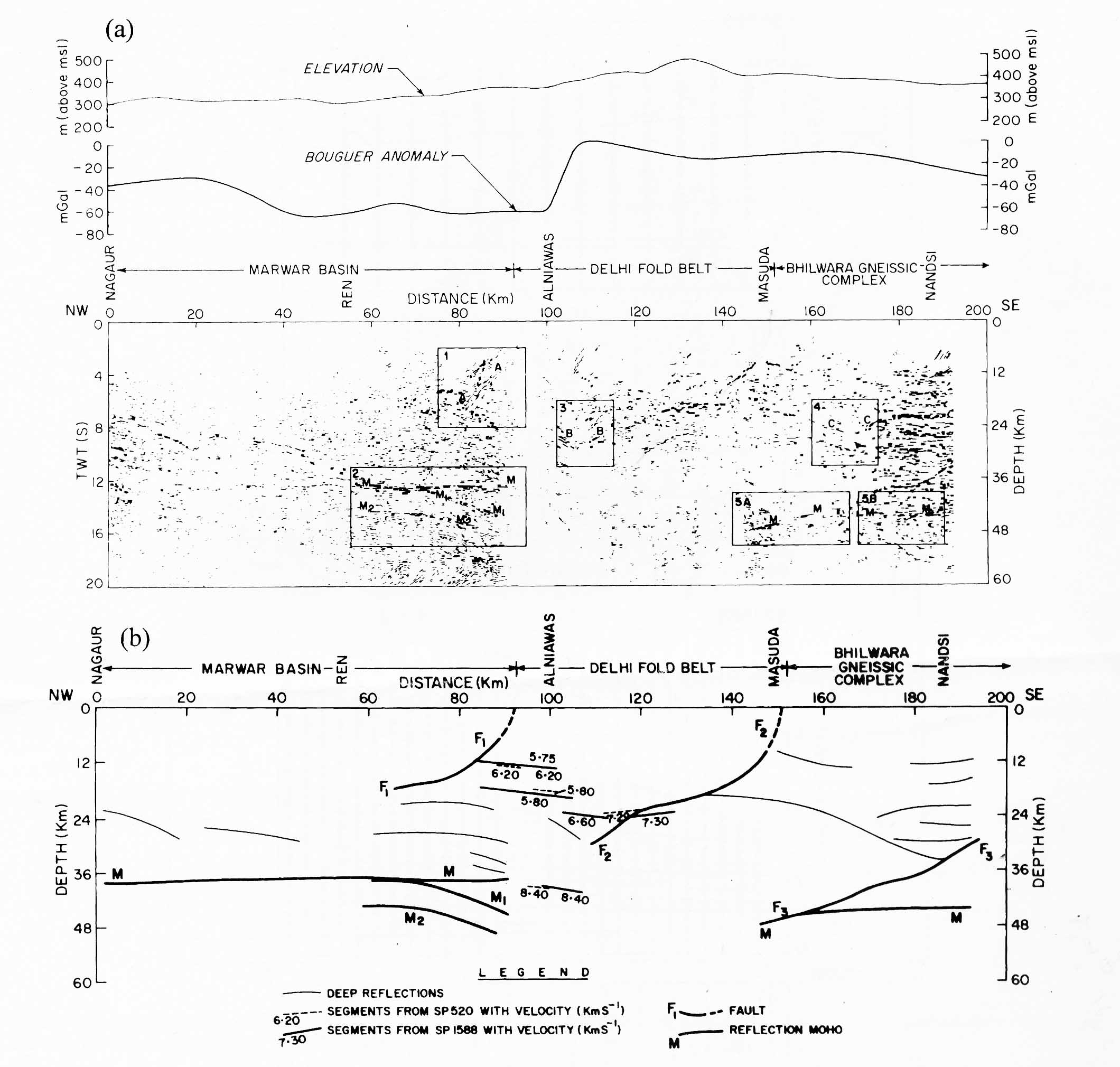
The reflection profile (unmigrated) seems distinctive below each of the tectono-stratigraphic units along the transect. A transparent top layer is prominent below the MB, which, below the 6 twt depth, gives place to a reflective crust dipping moderately to the SE. The crust is totally transparent below the Vindhyan basin in the SE and part of the Hingoli Group. Notably the type Palaeoproterozoic Aravalli fold belt does not extend into the transect corridor as it terminates further SW. The most interesting reflection structures are below the DFB, the SC and the MC in the central part of the transect. The reflective crust is quite shallow in these segments and textural evidence suggests that the reflective crust below the MB may have been uplifted (exhumed) below the DFB (Tewari et al., 1997a). Three prominent reflective features characterise the crust below the DFB-SC-MC--- (i) a SE dipping zone of reflection underlies most of the DFB and gives place to (ii) a hyperbolic reflection surface below the SC and along the transition from the DFB and (iii) the reflective units end upon the SE as a prominent moderately NW- dipping reflection zone below the MC, which may be a thrust zone referred to as the Jahazpur Thrust, after the township in this sector. These three features possibly tie up the tectonics below the DFB-SC-MC tectono-stratigraphic units. The Jahazpur thrust is a consequence of the exhumation of the LC that then outcrops as the SC. The SE dipping reflection zone dipping down into the DFB defines the synclinal limb of the Delhi basin. It is possible that the formation of the Delhi basin and the exhumation that brought about the Jahazpur thrust are coeval in time, opening up the possibility that the formation of the Delhi basin itself is a result of differential exhumation of the LC.
A fourth significant feature below the DFC-SC-MC sectors is the two listrict faults F1 and F2, that end up in the middle crust and fault F3 that underlies the SC and is a mantle fault. F2 and F3 delimit the exhumation course of the SC. F1 separates the Marwar Region from the DFB. The Marwar region experienced a 200 million year long period of extensional tectonics and alkali-basic magmatism associated with the Erinpura- Malani Igneous suites in the period between 850 Ma and 660 Ma (Neo-Proterozoic). The crust, as a whole, may have been transformed by the extensive magmatism and accompanying hydrothermal fluid action. The LVL shown in the velocity profile of Satyavani et al. (Figure 11b) is consistent with the magmatic history. The area is underlain by a well-developed flat reflection Moho, consistent with the predominant extensional history spanning some 200 million years, as extensional episodes are known to eliminate crustal roots below pre-extension orogenies (Mooney and Meissner, 1992,p 58). The listric fault F1 bounding the Marwar basin to the east merging with the reflectivity of the deeper crust may also be a product of the distension – a gravity fault. The Moho shows some branching that may be related to the banding in the ultrabasic formations of the mantle.
The Moho below the DFB is non-reflective and may be a transitional Moho formed during the Delhi orogeny, a gradual transition from mafic LC to ultramafic upper mantle. (see Mooney and Meissner, 1992, p. 51 quoting Pavlenkova, 1987,1988).
A 70 mgal gravity high correlates well with the zone of hyperbolic reflections in the DFC associated with a 7.3km/sec velocity layer. This has been taken as evidence for the underplating of the DFB by dense basic medium. (Figure 9a). However an alternative may be an exhumed LC concordant and consistent with the hyperbolic reflections and an elevated Moho.
The crust below the Vindhyan basin, despite being transparent may be a non-reflective LC, as the up dip of the Moho below the basin points to the possibility of the LC rising correspondingly. This is consistent with gravity modeling (cf. D.C. Misra et al., 2000) and the velocity structure obtained below the Vindhyan basin in the Central region discussed later in this paper.
The converging seismic reflection fabric and the bi-modal density structure across the profile have been explained by almost all the publications cited above as indicating the role of plate tectonic processes that dominated the orogenic cycles in the Rajasthan region. This is now a common approach in geophysical modeling but is non –unique.
The most prominent reflective surfaces in the N-J seismic reflection profile across the Aravalli-Delhi fold belt are the NW dipping crustal scale Jahazpur surface in the east and the NW dipping surfaces below the Marwar Proterozoic basins. The former is more or less confined to the Mangalwar complex of an amphibolite facies, juxtaposed against the green-schist Hindoli group. The NW dipping reflections may, therefore, be thrust reflections resulting from mineralogical layering accompanying a ductile flow. The nature of the reflections below the Marwar basin is not understood as, due to a lack of velocity structure, it is not possible to infer the nature of the host rocks. The possibility of these representing the exhumed generally reflective LC that may underlie the Marwar supracrustals cannot be ruled out. The Sandmata zone of outcropping charnockitic and other high-grade rocks separates the two regions of prominent reflectivity and the reflective surfaces terminate against this complex of exhumed rocks. This is consistent with an exhumation around 1600 Ma, as judged from geochronological data that therefore postdates the Mangalwar/Hindoli formations. The Jahazpur thrust itself may be only an auxiliary consequence of exhumation of the Sandmata complex.
Models of collision do not take into account the time relations implied in a migrating acid magmatism that progressively moved westwards into the Marwar block. The different blocks have evolved on different times within the Proterozoic and therefore a collision model that does not relate to time is too diffuse. Though an explanation of the reflectivity and gravity due to collision tectonics is in keeping with several earlier models of plate tectonics applied to this region (Sugden et al., 1990; Sychanthavong and Desai,1977), it is very generalized and ignores the poly-orogenic character of the region and the reflective fabric that the LC can imbibe through the several changes that accompany the tortuous evolution of the total crustal structure through three orogenies, and the isothermal exhumation of the LC rocks to shallow crustal depths. The Sinha-Roy (1988) model of crustal evolution is one of opening of oceanic or near –oceanic basins by extension and rifting and the subsequent closure of the basins by transpression. The model implies an already existing Archaean basement, which may be the Bundelkhand-BGC protocontinent. The Archaean basement with the several granulite bands in them has been obviously exhumed before or during 1600 Ma. The relation of the exhumed lower to middle crustal rocks to the DFB, is consistent with the hypothesis that the Delhi basin itself may be a result of extensional environments associated with exhumation. Such regional exhumation may,.as in southern shield be, the result of transformation of the LC during several the acid magmatic events and related hydrothermal activity, which imparts to the LC a negative buoyancy. As in the south Indian profile, the reflection fabric may possibly be related to the extensional exhumation of the LC during which the rocks would have developed a mineral fabric in response to the changing P-T–t paths of their exhumation. The shear zones in the reflection profile may have resulted during the differential ductile exhumation of these rocks and may not be specific to any tectonic feature, like collision. There is thus a parallel with the SI HGD.
Bundelkhand Cratonic Block
The Bundelkhand gneissic complex (BGC) outcrops as a major inlier within the arms of the Meso- Neoproterozoic Vindhyan basin. The Vindhyan basin separates the BGC from the Aravallis in the west and the Central Indian tectonic zone in the south The BGC is now considered a cratonic block, a highly deformed Archaean granite- greenstone terrain with relicts of ultramafics, amphibolites, fuchsite quartzite, banded iron formations, schists, marbles and calc-silicate rocks, that occur in a dominant but composite mosaic of granitic rocks of ages ranging from 3.3 Ga to 2.2 Ga, the granitic gneisses of Babina –Jhansi and the Badera migmatites representing late phases of 2100- 2400 Ma time span. (Basu, 1986; Sharma,1998; Sarkar et al., 1984) (Figure 12). If we consider the younger phases of granitic rocks as overprints equivalent to the Darwal Granitic phase in Rajasthan (Table II), the continental crust in the Bundelkhand segment was cratonised by the close of the Archaean and early Proterozoic, very much like the Karnataka craton in southern India. The different granitic rocks of the Bundelkhand craton bear close geochemical resemblance to the basement gneissic complex in the Aravalli-Delhi orogenic fold belt to the west. Based on the similarities in geochronology and geochemistry, it is proposed that these two granitic domains evolved as a single crustal unit stabilizing around 2.5 Ga. (Mondal et al., 2002). The Vindhyan basin that intervenes between the two granitic domains, therefore, is an intracrustal basin, that grew over a common platform of Archaean gneissic rocks. The cratonisation in the Bundelkhand region has a parallel in the cratonisation of the Western Dharwar craton by late Archaean ( ~ 2500Ma.).
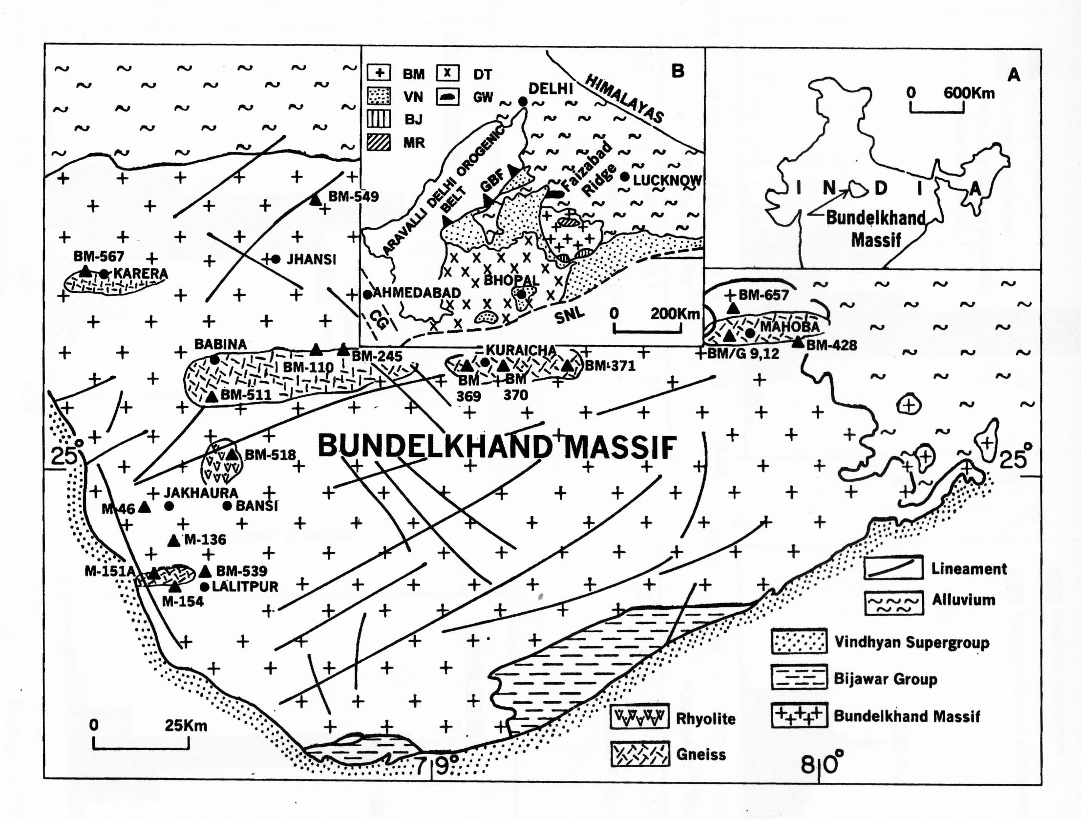
Numerous basic dykes of ~ 1800 Ma (Sarkar et al. 1990) intrude the Bundelkhand Granite and of particular interest are the dykes of peridotite-pyroxenite bodies in Angour and the ultrabasic and basic rocks of Hirapur, Madaura and Baraith-Girar (Basu, 1986). The lower Vindhyan sediments (Semri Formations) are intruded by diamond-bearing ultrabasic rocks, possibly lamproites. These are dated 1090 Ma (Rb-Sr whole rock; Anilkumar et al. 1993). Considering the source regions of diamondiferous kimberlites, it would seem the lithospheric thickness below the Vindhyan Basin and the Bundelkhand craton may be of the order of ~ 150- 200km at this time (Mukherjee et al., 1997). The presence of diamondiferous kimberlitic rocks in the Bundelkhand craton also bears a parallel to similar occurrences in the eastern peripheries of the Dharwar craton along the margins and interior of the Cuddapah basin.
Geophysical Data- Gravity Data
Spectral study of the gravity field in the region around Jhansi leads to the identification of three gravity interfaces at 1.5 km, 11 km and 32 km. These are correlated with the Moho , the Conrad and some shallow features.(Misra and Tiwari,1981). However considering the deep cratonic character of the Bundelkhand crust as evidenced by the emplacement of diamondiferous rocks, the Moho depths of 32 km seem rather too shallow. One possible reason is that there may be some underplated high density layers, ignored during gravity model. A clear picture of the deep continental structure may arise only when we have seismic profiles across the Bundelkhand craton.
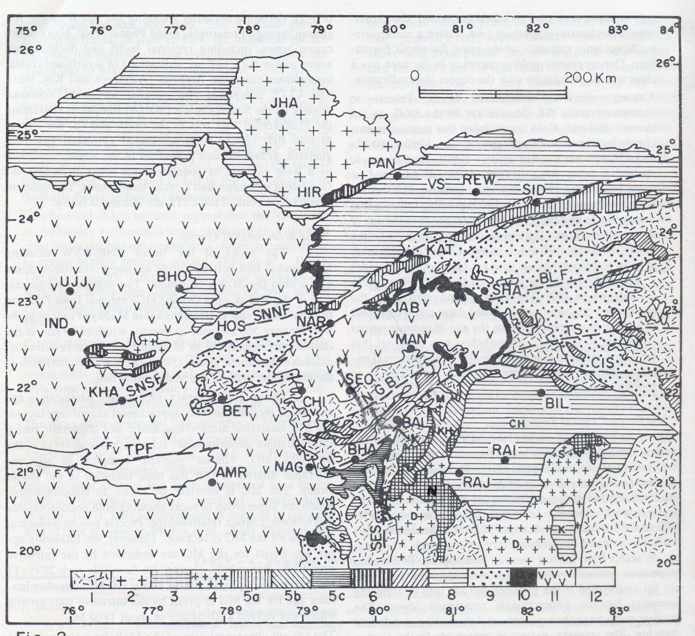
Central Indian Region
The CIR straddles the region between the Vindhyan Basin encircling the Bundelkhand craton in the north and the Bastar craton (also referred to as the Dharwar craton in literature) in the south. Outcropping between these cratons are the two distinctive crustal blocks .The northern crustal block (NCB) is what has been termed as the “central Indian tectonic zone”(CITZ) fringing the Bundelkhand Craton – Vindhyan platform to the south with a tectonic boundary marked by the SSNF (Figure 13)(Acharya and Roy, 2000; Roy et al., 2000). The CITZ supports the Sausar, Bijawars and Mahakosal Groups of supracrustals and the prominent Narmada-Son-Tapti tectonic lineaments (SONATA). The southern crustal block (SCB) is the Kotri-Dongargarh block, with the Sakoli and Dongargarh supracrustals fringing the Bastar Craton. Separating the northern and southern crustal blocks is an ENE-WSW trending steep dipping shear zone, but herein called the Central Indian Shear Zone (CISZ) (contra Jain et al., 1995). This shear zone is situated along the southern boundary of the higher-grade Sausar mobile belt (SMB) with the extensive Tirodi gneisses that host dismembered charnockitic rocks and some cordierite meta-pelites both to the north (the Rambona – Katangi belt) and south of the Sausar supracrustals (~100km long Balaghat belt) (Bhowmik et al., 1998). South of the CIS are low-grade rocks of the Sakoli, Nandgaon, Chilpi and Khairagarh Groups of low-grade supracrustals, constituting the possibly the northern part of the Bastar craton. The earliest phases of deformation of the SMBtruncate and rotate the N-S oriebted structures of the Palaeo-Meso-Proterozoic Sakoli- Kotri fold belt. (Acharya and Roy, 2000). The CIS is, therefore, in the nature of an intracrustal shear zone (thrust) that brings a deeper crustal segment in the north against a shallower segment in the south. It is a parallel to the Fermor line in the South Indian Shield, but is more linear in character. Recent interpretations of the aeromagnetic data suggest that this shear may extend northeastward and merges with the NW extension of the Sukhinda thrust. (Mita Rajaram and Anand, 2003). Assigning a collision status to this shear zone seems geologically poorly constrained.
Prominent intrusives in the region include several phases of ultrabasic, basic and acid igneous rocks. Prominent among them are the phases of Dongargarh- Jabalpur granites of the time span of 2.4 to 2.1 Ga, the Amgaon and Barambaba Granites of 2.0 Ga ; the Bari Syenite and Jirgadandi pluton of the time span 1.75 to 1.8 Ga ; and the Tirodi Gn and Keshkal Granite of 1.5 to 1.6 Ga. Along the eastern fringes of the CIR are the Kunkuri granites dated around 803 Ma. and several S-type granites of the Neoproterozoic. In other words, the CIR as a crustal segment has been the foci for several episodes of thermal interaction between the mantle and the crust in the whole of the time span of the Proterozoic. (Table 2).
Diamondiferous kimberlite pipes (~1110-1300 Ma) are emplaced in several locales of the CIR along the fringes with the numerous Mid- to Neo- Proterozoic sedimentary basins, namely the Khariar and Indravathi and fringes of the Vindhyan basin at Panna. These, along with the kimberlites along the western margin of the Cuddapah basin and those SE of Hyderabad constitute the diamond kimberlite belt. The Jungel ultrabasic dykes in Central India have been dated ~803 Ma. These possibly indicate that deep cratonisation has set in the CIR well before 1100 Ma to the source depths of diamondiferous kimberlitic rocks, placed at ~ 200km. The seismic tomographic roots in Central India depicted in the K-W model are consistent with the kimberlite belt.
Much of the NCB is under cover of the Gondwanas, the Deccan basalts and Recent Alluvium. The SONATA belt is an ancient fault-bounded horst–graben tectonic complex that straddles ENE-WSW across a region of largely under cover of Deccan Trap-Gondwana- Alluvium cover. Much of what we know about this belt is based on the seismic profiles. The SONATA belt separates the Neo-Proterozoic Vindhyan Basin and the Bundelkhand Granitic Complex in the north from the rest of the NCP. This lineament has been reactivated repeatedly from the Precambrian to the Present (Table II; Figure 13). (see A.Roy et al., 2000, for a recent review).
Geophysical Features - Gravity Data
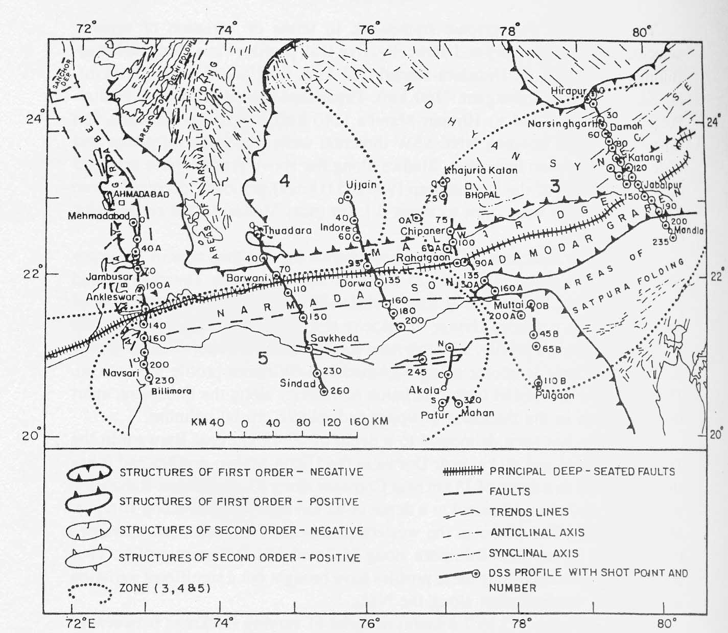
The region shares the Bouguer anomaly field. with the Rajasthan region (Figure 5). The Bouguer gravity fields have been modeled in terms of the thicknesses of the U C, LC and the depth to the Moho using different wavelengths by Nayak (1990) and Agarwal et al. (1995); Sivaji and Agarwal (1995). They all emphasise the different degrees of exhumation that thereby lead to thinner UC and thicker and shallower LC and shallower Moho. A 3-d relief map of the Moho discontinuity (Agrawal et al., 1995) identifies the SONATA as a zone of Moho upwarpment associated with rift tectonics. The Central Indian region is also characterized as the meeting region of three triple rift-rift junctions, the Son-Damodar-Mahanadi rifts intersecting at Shadol in the east, the Narmada- Son-Godavari rifts intersecting at Pachmarhi in the center and the Narmada -Cambay rifts intersecting near Banswara in the west. Contributions of D.C.Misra et al. (2000) are discussed a little later along with the transect results.
Data from Transects
Four DSS profiles across the SONATA belt provide deep insights into the structure and deep crustal features along this belt, largely covered by Deccan Traps, the Gondwana sediments and large alluvial patches. A seismic reflection profile runs across the CIS from Mungwani to Kalimati (M K profile) and throws light on the features below this shear zone (Kaila and Krishna, 1992, and references therein).
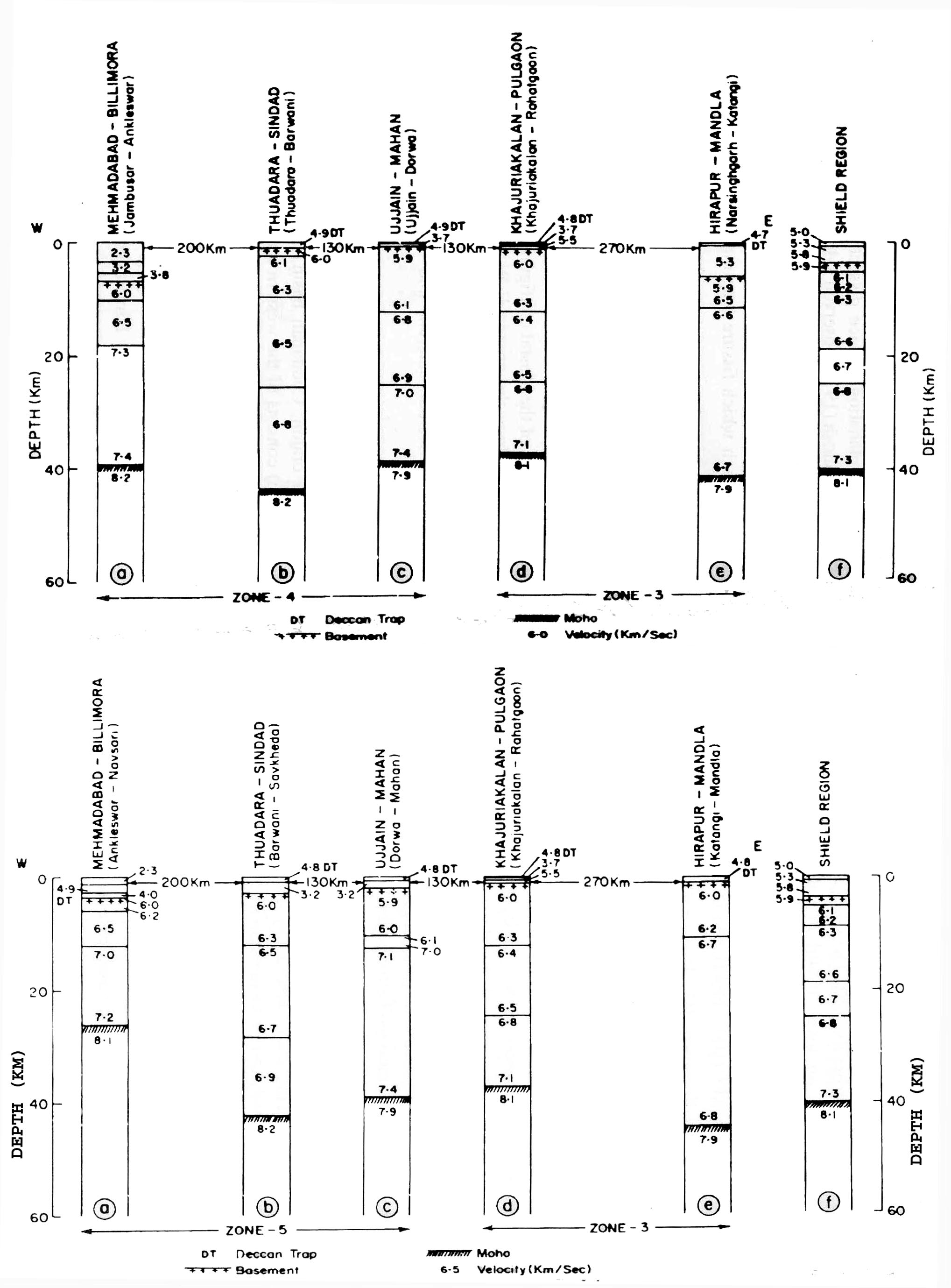
The DSS along the (i)Thuadara-Sindad, (ii) Ujjain-Mahan, (iii) Khajuria Kalan-Rahatgaon, and (iv) Hirapur-Mandla profiles (Figure 8, Figures 14) provide a comprehensive picture of the velocity structure and to a lesser extent the reflectivity of the crust underlying this belt. across the Narmada-Son lineament (Figures 15a &b). The profiles are each about (~) 250 km long. In almost all discussions of the DSS profiles across Central India, it has become customary ( eg. Reddy et al. 1999) to generalize the features of the Sonata-Belt drawing on the features in the Mehmadabad-Billimora profile (part of D-B profile in Figure 8). This profile is along a distinct crustal province deeply affected by the west coast rifting and has, in fact, such unique features as a prominent (~10 km thick) zone of denser LC overlying the MOHO that may represent a rift cushion. or material due to underplating (Figure. 15 b (a)) Such a horizon is not conspicuous in the 4 profiles further east across the SONATA belt, though some spot values of higher velocity have been registered in some of the profiles. Drawing conclusions of extensive under plating in the SONATA belt therefore seems far-fetched, though under plating on a much smaller scale seems likely. (see below).The P-wave velocity layering is also very distinct in the SONATA belt further east of Long 74o (Mahadevan, 1994, 1995).
The main features of the 4 DSS profiles along the SONATA belt may be summarized here.
1.The profiles bring out prominent E-W trending horsts and grabens bound by deep mantle faults. The grabens host the Bijawars, Vindhyans, the Gondwanas / concealed Mesozoic sediments and the Deccan traps in different segments and could be episodic and younger to these formations. The Deccan basalt flows do not exceed some 100m of thickness in the region as against thickness of some 1to 2 km along the west coast..
2.The crustal thickness ranges from 38 –43 km compared to the average thickness of 35 km assumed for the Indian crust , implying crustal thickening. The Moho shows gentle upwarps between the Narmada and Tapti of the order of 2 kms and may be indicative of crustal distension.
3.The upper crustal thickness is rather thin, compared to standard continental crust, being some 12 –14 km thick, except in the Hirapur_-Mandla profile, where the Vindhyans seem to overlie a layer of 6.5 km/sec velocity and the U-M profile, where there are indications of a near normal crust. Between Damoh and Katangi, in the central part of the H-M profile, where the deepest part of the Vindhyan basin is delineated along this profile, a high velocity between 6.5 to 6.7 km/s is observed immediately below the sediments, and may correspond to the basement in this region (see also Sain et al., 2000). Similar high velocity of 6.7 km/s is also observed at a depth of about 2 km immediately below the exposed granites (velocity 5.9 km/s) between Katangi – Jabalpur block, as well as between Batiagarh and Damoh at a depth of 4 to 8 km. (Reddy et al., 2003). Moho upwarp has been inferred below Katangi and Jabalpur (Murthy et al., 1998). Part of the positive gravity anomalies in the region may be due to the absence or the thinness of the upper crust, apart from accompanying Moho uplifts and is suggestive of a pre- Vindhyan uplift along deep faults, erosion and removal of the granitic layer and subsidence followed by Vindhyan sedimentation (Kaila et al.,1989; Murthy et al., 1998). Notably this feature helps to date the exhumation of the Lower crust in the region as Pre- Vindhyan (> / =1600Ma) (Mahadevan, 1995). This tallies with the reset younger ages of granulites of Rajasthan already referred to.
4.The DSS profiles reveal a highly reflective crust, almost uniform, that is consistent with the dominance of the lower crustal segment in the region. The causes for such high reflectivity may be lithological layering, ductile shear banding and /or trapped fluids. Gravity- seismic modeling suggests a high density mid-crustal magmatic body between Jabalpur and Mandla (Mall et al., 1991). Travel time and synthetic seismogram modeling has revealed the presence of high velocity subhorizontal layers (7.0-7.3 km/s), from a depth of 8-12 km down to the MOHO discontinuity (Reddy et al., 1997). This may, however, imply a dense lower crust in the region. The boundary velocity of the MOHO discontinuity of 7.9 km/s has been traced reliably between Indore and Tapti river and may imply relatively lighter or a warmer subcrustal lithosphere in the region.
Recent geoelectric sections across part of the H-M profile (Damoh- Jabalpur-Mandla) have revealed two deep conductors, traced from depths of 5 km to ~50 km with a resistivity of 10-50 Ω-m, the southern of the two being within highly reflective layers. It is suggested that these may represent fluid-charged layers or partial melts, resulting from the impact of Deccan Volcanism (Gokarn et al, 2001).
The data from the reflection profiling along the Mungwani-Seoni-Katangi--Kalimati (NW-SE) profile (Figure 16a) demonstrates (i) a change in reflectivity character across the CIS zone, with prominent reflectors in the NW segment corresponding to an exhumed Lower Crustal rocks that outcrop as the Tirodi Gneisses and the granulite enclaves in them and (ii) a band of reflectors dipping southward at the north end of the profile and north dipping reflectors at the south end, beneath a little to the NW of the CIS zone . The Moho depths are in the range of 40 to 45 km, indicating a thickened crust .The dipping reflectors and the crustal root zone characterized by Moho offset are interpreted as a zone of subduction or under thrusting of continental crust in the collision zone by Reddy et al. (2000). It is, however, noteworthy that the CIS brings up the basement of a mid-lower crustal character to the Sausar Group of supracrustals against the upper crustal setting in the Bastar craton (cf.Acharya and Roy, 2000). The reflectivity patterns may, therefore, be a feature related to the intracontinental tectonics and the exhumation of the Lower Crust.
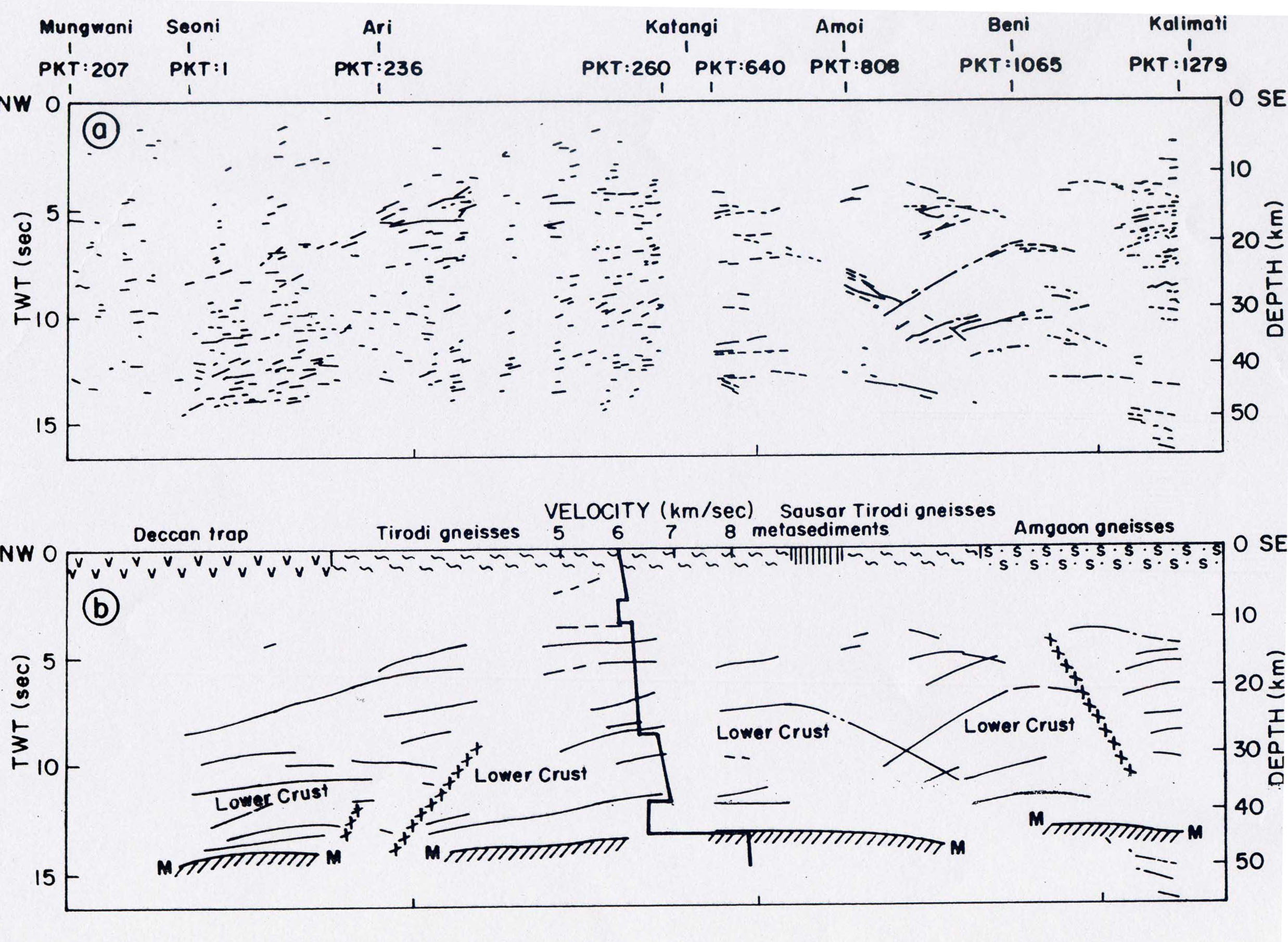
A five layer crustal velocity model has been ob-tained along the Mungwani-Seoni-Katangi--Kalimati) profile (Figure 15b) by forward modeling of seismic wide angle reflection data acquired from two major shot points (0 and 100) in the Seoni-Katangi section. The structure, which includes two low velocity layers. The depth to the Moho boundary obtained from the refraction data agrees well with the depth of the reflection Moho. The crust - mantle boundary is at depths of 40 – 45 km all along the profile, but Moho reflections extend deeper in the southern part at depth 45 –50 km.
Velocity structure for the region between Katangi and Kalimati has been worked out utilizing the algorithm of Megallaa using rms velocities with necessary corrections. The structure so obtained is presented in figure 17 a , along with a subduction-collision reconstruction (Figure 17 b). (P.R.Reddy and Satyavani, 2001).
As in the other areas discussed, reflectivity profiles and a velocity structure of second order resolution and gravity fields are interpreted to generate a generalized collision /subduction model for the Central Indian region (Reddy and Satyavani, 2001, Reddy et al., 1995; Misra et al.,2000). The model relies on a characterization of the CIS as a suture (Jain et al., 1995), which remains debatable (Acharya and Roy, 2000). The model characterizes as Upper Crust, the exhumed and transformed Mid- to Lower Crustal rocks that are exhumed to shallow levels and outcrop on both the fringes of the Sausar supracrustals belt which itself is metamorphosed to amphibolite facies.(17b). The velocities of 6.1 km/sec obtained here are of the reset mid- to lower crust. Secondly correlating a subducting Lower Crust to a 7.9 km /sec. layer in the mantle seems far-fetched, as, with the precision less or more by 5% claimed for the values, this value may not be very different from the 8.1 km/sec boundary velocity generally obtained for the mantle in the Central region. The Central Indian region has passed through several episodes of extensional tectonics during the Proterozoic and the Mesozoic that were punctuated with the emplacement of large plutonites (Table II), the formation of several basins of sedimentation, some accompanied by basic volcanism and a large number of basic and acid magmatic events including the Deccan basalts. It is unrealistic to interpret the reflective layers in the mantle with P-wave velocities of 7.9 km/sec with a subducted LC.
Discussion
In the foregoing account several geological contradictions in current 4-D modeling of geophysical data have been emphasized that render the models of collision imported from the Phanerozoic unreal and not easily reconcilable with several geological facts. Models of collision are based on empirical formulations of converging reflections and bi-modal gravity fields that are not be unique to collision. Models of collision proposed project events of different time frame to a single frame. They are therefore simplistic. The basic approach in this paper is to consider the Indian shield as one Archaean continent that was cratonised progressively from a central core in the Archaean to the peripheries in the Proterozoic. (Mahadevan, 1999) The thermal regimes in the Archaean may have been more uniform across the whole of the continents but became distinctive in different segments that cratonised in the Proterozoic. The two regions selected for this paper based on the large volume of data available, namely the South Indian High Grade Domain fringing the Dharwar craton to the south and the NW and Central regions of the shield, fringing the Dharwar craton on the north, represent two distinctive Proterozoic provinces. The former evolved into a distinctive HGD characterized by two major intra- continental rift zones, namely the Dharmapuri rift zone and the Palghat-Cauveri rift zone. These became the centers of several generations of ultrabasic, basic, alkaline and granitic magmatism that resulted in a modified Lower Crust imparting to it a negative buoyancy. This negative buoyancy led to the most widespread and penetrating characteristic of the Indian Precambrian crust namely, the repeated large scale but differential and episodic penultimate isothermal exhumation of the Lower Crust in different parts of the shield. The differential exhumation of different segments depending on average densities of the transformed LC generated numerous ductile near vertical to steeply dipping shear zones, which are being characterized as collision zones.
The seismic profile of the south Indian shield runs across two intracontinental rift systems, the Dharmapuri rift and the Palghat-Cauvery rift zone. The prominent LVL in the 4-layered velocity structure; the long wavelength Bouguer gravity anomalies and the magnetic and electrical conductivity crustal layering now identified may be primarily due to an intrinsically lighter transformed lithosphere resulting from the penetrative magmatic and hydrothermal interaction driven by the hot mantle below. Considering the long wavelength of the negative anomalies, a possibly lighter lithospheric mantle is indicated which may result by interaction with several fluids either of crustal origin or mantle origin that have been activated necessarily by the thermal regime of the mantle. The sequential magmatic episodes indicate that the thermal regime migrated from the Dharwar craton in the north around 2500 Ma to the south over the rest of the Proterozoic. The predominant impress of the Pan-African orogeny along the southern and SW tip of the shield (in Kerala) is, therefore, a consequence of the migration of the mantle thermal regime.
A natural consequence of the transformation of the LC into a lighter crust and a lighter mantle is its negative buoyancy and consequent large-scale regional exhumation, in an effort to maintain mass equilibrium. A close temporal relation established between the sequential magmatic episodes and exhumation history of the several segments of the South Indian shield establishes a direct connection between stages of transformation and corresponding exhumation. Records of Archaean protoliths are available in both the Northern ( north of the Palghat-Cauvery rift zone) and Madurai blocks but are absent in the Kerala block possibly due to the more intense transformation of the Kerala block and, even more importantly the predominance of supracrustals in this block suggestive of a lower level of exhumation as not to expose the deeper segments of the charnockitic basement. Judged from the variable depths of both exhumation inferred from the P-T-t paths defined and also the predominance of the supracrustal (khondalitic) cover, the south Indian shield presents a picture of an ensemble of differentially exhumed blocks. The various steep shear zones or faults of continental dimensions, presenting characteristics of ductile shears, fit into this model of differential isothermal exhumation. Exhumation of the LC under a tectonic regime of isothermal decompression in the span of the Proterozoic is the most significant and valedictory tectonic event in the history of the Precambrian evolution of the south Indian Shield. The seismic reflection fabric has necessarily to be related to the mineral fabric that would result from recrystallisation during an isothermal decompression and exhumation to higher levels of lower pressure.
A second penetrative feature is the emplacement of a number of phases of ultrabasic, basic and alkaline rocks of varying densities as more or less vertical columns into the lower crust. The granitic and syenitic plutonites dominate over the rest of these intrusives in volume. These features along with the exhumation tectonics, have the potential to bring about contrasting heterogeneity in the crust that can affect the travel times of seismic waves and also influence greatly the gravity and magnetic fields. How far the all-pervading low velocity layer may be an artifact of the influence of these vertical heterogeneities also needs to be analysed. The crustal fabric determined by multi-disciplinary approaches is specific to two zones of intracontinental rifts. How far they are applicable to the rest of the shield especially to the mountainous terrains of the Biligirirangan, Nilgiri and Anaimalai complexes of more massive charnockitic rocks remains to be established. The crustal fabric can, on the other hand, be taken as typical of intracontinental rifts and viewed in this light, the contribution to our understanding of Precambrian crustal structure as a whole is phenomenal. However, the models of collision, very much generalized and non-specific in several details (Reddy et al., 2003; Singh et al., 2003), based on dipping reflection fabric and bimodality of gravity fields seem too simplistic.
There is no indication in the velocity profiles that any material from the mantle has underplated the crust below the HGD. This re-validates the crustal thickness of > 60 – 75 km thickness that was assigned to the late Archaean crust below the HGD, (one of the conditions being the absence of any underthrusting) (Harris et al., 1982). However, a question that remains to be addressed is the time gap of nearly 1250 million years before the close of the Closepet Granitic events of ~2500 Ma and the next phases of alkaline magmatism in the Dharmapuri rift zone around ~750 Ma when the region must have remained stable, possibly as an Archaean crust. It is possible that a mantle plume event below the region may have led to the delamination of the subcrustal lithosphere around this time exposing the crust to the thermal regime of the mantle. The onset of an extensional tectonic regime consequent on this delamination may account for the configuration of the reflection Moho that seems to coincide with the refraction Moho wherever the latter has been experimentally determined .in the seismic profiles. Though speculative, these are possible directions along which the seismic profiles can be interpreted in relation to crustal evolution. The consequences of rheological responses of the Lower Crust to a setting of negative buoyancy, as discussed by Meissner and Mooney (1998), also need attention.
In region II, the trend of crustal evolution seems to have taken a different path. The long wavelength more positive gravity anomalies over the region as a whole are consistent with a thinner and perhaps denser lithosphere. Bundelkhand cratonic block and its eastward extensions into the Ganga alluvial basin as the Budelkhand –Allahabad Ridge and the Samania – Sitamarhi ridge (see pp. 495-496 and figure.19.3 in Mahadevan, 2002 for more details) is a parallel to the Dharwar craton in that it witnessed early cratonisation and even, perhaps, uplift that led to the formation of the Lower Vindhyan basin. The Bundelkhand – BGC Archaean continental block has been the site of a series of rifts leading to the Aravalli and Delhi Basins which in places opened up the oceanic crust and later closed due to the on set of compression. The seismic profiles are across these zones of tectonic inversion within an Archaean continent. In this view the Marwar block is a part of the Archaean continent that has been later subjected to the extensive magmatism in the Neo-Proterozoic due to a thermally energized ancient crust by interaction with a hot mantle. The Central Indian Tectonic Zone, including the SONATA belt cradles between the Bundelkhand-BGC craton on the north and the Bastar- Dharwar craton on the south and is perhaps the most reactivated part of the Indian shield by repeated episodes of transtension and transpression.
The Aravalli-Delhi fold belt to its east and the Central Indian Tectonic Zone are the corresponding mobile belts, which got separated from the Bundelkhand massif by the extensional formation of the Vindhyan basin However, unlike the south Indian High Grade Domain, these Proterozoic mobile belts still preserve some of the Archaean greenstone-like vestiges, such as the Mahakosal, Bijawar, Hindoli and other complexes. The Proterozoic transformation with attendant largely tholeiitic but also relatively minor andesitic and granitic magmatism is an overprinting on an Archaean basement of which the greenstone-like supracrustals are relicts. The regions present a higher crustal level compared to the SI HGD or the EGMB, as the exhumation of the LC has not been as large as that witnessed in the SI HGD, possibly due to a denser lithosphere. Several seismic profiles indicate that the upper crustal thickness is much lower than the standard continental crust (Table 3.). In the Hirapur-Mandla profile the basement of the Vindhyans has a lower crustal velocity, implying that exhumation of the LC is pre-Vindhyan (say >1600Ma). The CIS, often called a collision zone, in fact brings up the Mid-to Lower crustal rocks in the north against the upper crustal supracrustals and gneisses in the south.The CIS, therefore, is just an intracontinental ductile shear zone, an interface between two differentially exhumed segments. The basic difference between the SI HGD and the Region II is that the thermal regimes have overprinted an Archaean crust less effectively so that remnants of the Archaean supracrustals are still evident. So the differences in the trend of evolution in the two terrain have been initiated well in the Archaean, possibly due to a distinctive mantle thermal regime.
The exhumation of the Lower Crust is a major Precambrian tectonic event also in the case of both the Aravalli- Delhi belt as well as the Central Indian region. The seismic profiles structure across the SONATA belt and across the Aravalli-Delhi belt testify to this differential exhumation. The M-K seismic profile across the Central Indian Shear also reveals a close relation to the exhumation tectonics of the high-grade Sausar mobile belt from the Sakoli supracrustals. Here there are opposing dips converging on a ductile CISZ.The Lower Crustal rocks of the Region II could not exhume up to the same levels as the SI HGD or the EGMB and on this count the lithosphere may have been rendered denser even in the Precambrian. Notably, the Rajmahal and Deccan continental basalt volcanism that pervades the whole of the Central region could, by processes of under plating and dyke formation, have also rendered the lithosphere heavier. Thus it would seem that the dense lithosphere in Region II is both a Precambrian and Phanerozoic feature. Gravity modeling has therefore to apportion the contributions of each of these factors to the gravity field. The course of evolution is too complex and gravity models that propagate a bimodality of the Bouguer anomalies as an evidence of Proterozoic subduction and suturing of continents without separating contributions of the extensive Phanerozoic magmatic events are indeed simplistic.
The vestiges of a dense lithospheric band extending beyond a general 100km thickness of the central Indian lithosphere in the K-W tomographic model have implications on the lithospheric evolution of this region. The presence of a the central Indian kimberlite belt and the recent finds of late Mesozoic (?115 Ma)orangeite dykes (Kimberlite II) in the Gondwana Formations of the Damodar valley Coal belt implies that the central Indian region had a lithosphere with tectospheric roots extending to depths of > 150-200 km or so, the probable source depths of these rocks. If this assumption is true, the present lithospheric thickness of ~ 100 km estimated in Central Indian regions both by the K-W tomography model and surface wave studies ( Singh, 1991) implies an erosion of the lithosphere subsequent to 115 My through mantle interaction. On these grounds the Deccan magmatism of very large magnitude that pervaded the whole of the Central region around ~65 Ma may have brought about a lithospheric mantle erosion of a large thickness. The large crustal contamination reported in Deccan lava flows may be consistent with such a possibility. Such erosion of the lithospheric roots have large implications in geophysical modeling that needs attention.
A Working Model of Continental Evolution
Continental evolution is the story of crust- mantle interaction in response to the thermal evolution of the mantle interior. The sequences in cratonisation of the crust, resulting from a cooling mantle can, therefore, be a temporal index of the thermal evolution of the mantle (Mahadevan, 2000).
The geophysical characteristics of the SIHGD may be viewed in the context of a working model of changing temporal and spatial lithosphere-mantle interaction. It has been suggested that with the progressive cooling of the mantle, the convection cells may have passed from a turbulent state in the Archaean to organised stable convection cells in the Proterozoic (Durrheim and Mooney, 1994). The Southern Indian Shield possibly provides an example that satisfies these two paradigms. The Dharwar craton was, perhaps, the first to cratonise by the Late Archaean- Early Proterozoic and may have evolved above a turbulent mantle that got depleted in the process. The HGD remained mobile throughout the whole of the Proterozoic, being situated over an upwelling enriched mantle (Figure 18). It possibly was cratonised by the middle Proterozoic and was later involved in the Pan African episodes of anorogenic granitic magmatism, which then carried the torch of deep crustal transformations, leaving several vestiges of the Archaean protoliths. It, therefore, seems that the Dharwar craton and the HGD were part of a continental segment, which responded to a differentially cooling mantle. The tectonics and magmatism and perhaps metallogeny of the HGD are the result of a thickened lithosphere closely interacting with a hot organized actively convective enriched mantle.
In region II, lithospheric evolution is a sequential overprinting of the Archaean crust and did not permit a dichronous divide as in the case of region I. The styles of thermal evolution of the mantle in the region has been distinct from that of region I. A model of convergent and divergent divides in the mantle thermal regimes may not hold good in the case of region II, the Archaean-Early Proterozoic thermal regime having been overprinted by the mid – to late Proterozoic thermal regime. The region II has been underlain by denser lithosphere in the Precambrian and this has restricted the exhumation of the LC to the same extent as in region I and the densification has been further accentuated by Mesozoic continental basalt episodes. These conclusions are indeed speculative and could be refined only when a larger geophysical database is available.
Acknowledgements
This contribution has been possible due to the unstinted and continued support the author has received from the Dept. of Science and Technology (ESS Division) during the last two decades providing great opportunities for exposure to ongoing researches on deep continental structure. Dr.K.R.Gupta , Advisor, DST (ESS) has been the fountain source of such encouragement. The author wishes to thank Dr Mita Rajaram for inviting him to contribute this paper and for offering several editorial comments for the improvement of the paper.
References
- Acharya,S.K and Roy, A. 2000. Tectonothermal history of the Central Indian Tectonic Zone and reactivation of major faults /shear zones. Geol. Soc. India. v. 55 (3), pp. 239 – 256.
- Agarwal, B.N.P;Das,L.K;Chakravarthy,K and Sivaji,Ch.1995.Analysis of Bouguer anomaly over Central India: A regional perspective .Mem.Geol. Soc.India no.31, pp.469 –493.
- Anil Kumar, Padma Kumari, V.M., Dayal, A.M., Murthy, D.S.N. and Gopalan, K. 1993. Rb-Sr ages of Proterozoic kimberlites of India: evidence for contemporaneous emplacement. Precam.Res, V.62, pp. 227-237.
- Balasubrahmanyan,M.N, Muthy, M.K, Paul,D.K and Sarkar.A. 1978.K-Ar ages of Indian kimberlites .J.Geol.Soc.India. V. 19,pp.584 –585.
- Baskar Rao, Y.J; Janardhan,A.S;Vijayakumar,T;Narayana,B.L;Dayal,A.M;Taylor,P.N and Chetty,T.R.K.2003. Sm-Nd model ages and Rb-Sr isotopic systematics of charnockites gneisses across the Cauvery shear zone, south India: implication for Archaean, Neoproterozoic terrane boundary in the granulite terrain. Mem.Geol. Soc.India. No.50, pp.297 –317.
- Basu,A.K. 1986.Geology of parts of Bundelkhand granite massif, Central India. Rec. Geol. Surv. India. V. 11(2), pp.61-124.
- Bhowmik, A.K; Pal, T, and Roy, A and Pant,N.C. 1998. Evidence for Pre-Grenvillian high-pressure granulite metamorphism from the northern margin of Sausar mobile belt in Central India. Jour.Geol.Soc.India. V. 53,pp.385 –399.
- Bose, M.K.1998.. Geochemistry of metabasics abd carbonitic rocks of Phulad in Delhi fold belt:implications for tectonic history. In. Ed. B.S.Paliwal; The IndianPrecambrian. Scientific Publishers (India), Jodhpur, pp. 242 – 262.
- Chaudhary, A.K, Gopalan, K and Sastry, C.A. 1984.Present studies on geochronology of the Precambrian rocks of Rajasthan. Tectonophysics, V. 105,pp. 131 –140.
- Crawford, A.R. 1970. The Precambrian geochronology of Rajasthan and Bundelkhand, Northern India. Canad. Jour.Earth Sci. V. 125,pp.91 –110.
- Crawford, A.R and Crompton, W. 1970.The age of the Vindhyan System of Peninsular India. Jour.Geol.Soc.India V.125, pp.351 –371.
- Desai, S.J, Patel, M.P and Merh, S.S. 1978.Polymetamorphitesof Balaram-Abu road area, north Gujarat and SW Rajasthan. Journ. Geol. Soc. India, V. 19,pp. 383 –394.
- Durheim, R.J. and Mooney, W.D. (1994) Evolution of the Precambrian Lithosphere : geological and geochemical constraints. J. Geophys. Res., V.99, pp.15359-15374.
- Fareeduddin and Kroner, A. (1998) Single zircon age constraints on the evolution of Rajasthan granulites. In: B.S.Paliwal (Ed.), The Indian Precambrian, pp.547-556
- Fareeduddin.2000. Polyphase granulite facies metamorphism in Rajasthan, tectono-metamorphic evolution and isotopic constraints. Geol. Surv.Ind. Sp.Publ. 55, pp. 307 –318.
- Fountain,D.M. and Salisbury.M.H. 1981. Exposed cross-sections through the continental crust: implications for crustal structure, petrology and evolution. Earth Planet. Sci.Lett. V. 56, pp. 263 – 277.
- Gokaran, S.G., Rao, C.K. and Singh, B.P. (1995) Crustal structure in southeast Rajasthan using Magnetotelluric techniques. In: S.Sinha-Roy and K.R.Gupta (Eds.), Continental Crust of NW and Central India. Geol. Soc. India, Mem. 31, pp. 373- 381.
- Gokarn, S.G, Rao,C.K , Gupta,G, Singh,B.P and Yamashita,M. 2001. Deep crustal structure in the Damoh- Jabalpur-Mandla region using magnetotelluric studies. Geophys. J. Inter-national. V. 144, pp.685 –694.
- Gopalakrishnan,K; Subramanian,V; Upendran, R and Viladkar,S.G. (2002). Fenitisation associated with Tirupattur alkaline syenite-carbonatite province, northern Tamil Nadu, India. In Abstract vol. National seminar on” Alkaline Carbonatite magmatic activities----“ March 30 –31, 2002.Dept of Geology, Kakatiya University, Warangal, A.P.
- Gopalan, K., Macdougall, J.D., Roy, A.B. and Murali, A.V. (1990) Sm-Nd evidence for 3.3 Ga old rocks in Rajasthan, northwestern India. Precam. Res., V.48, pp.287-297.
- Harish Kumar, S.B and others. 2003. Late Archaean juvenile magmatic accretion processes in the Eastern Dharwar craton: Kuppam-Karimangalam area. Geol. Soc.India. Mem. No. 50; pp. 375-408.
- Harris, N.B.W;Holt,R.W and Drury,A.A. 1982. Geobarometry, geothermometry and late Archaean geotherms from the granulkitic terrain of south India. Jour.Geol. V. 90, pp. 509 –527.
- Iyengar,S.V.P., Chandy,K., and Narayanaswamy,R.(1981).Geochronology and Rb/Sr systematics of the Igneous rocks of Simlipal Complex, Orissa. Ind. Jour. Earth Sciences. V.8, (1), pp. 61 – 65.
- Iyer,H.M, Gaur,V.K, Rai,S.S, Ramesh,D.S, Rao, C.V.R, Srnagesh, D and Suryaprakasam, K. 1989. High velocity anomaly beneath the Deccan VolcanicProvince: Evidence from seismic tomography. Proc.Ind. Acad.Sci. V. 98 (1), pp. 31 –60.
- Jain, S.C., Nair, K.K. and Yedekar, D.B. (1995). Geology of the Son-Narmada-Tapti lineament zone in Central India, project CRUMANSONATA, Geol. Surv. Ind., Spec. Pub. V.10, pp.1-154.
- Jayananda,M and Peucat, J-J. 1996.Geochronological framework of southern India. Gond. Res. Mem.no.3,pp. 53 –75.
- Kaila, K.L, Murthy,P.R.K and Mall, D.M. 1989. The evolution of the Vindhyan basin vis-à-vis the Narmada-Son lineament, Central India, from deep seismic sounding. Tectonophysics, V. 162, pp. 277 –289.
- Kaila, K.L and Krishna,V.G. 1992. Deep seismic sounding studies in India and major discoveries. Sp. Issue. Seismology in India – an overview. Current Science. V. 62,nos. 1 & 2,pp. 117 –154.
- Kennett, B.L.N and Widiyantoro, S. 1999. A low seismic wave speed anomaly beneath northwestern India: a seismic signature of the Deccan plume? Earth Planet. Sci. Lett, V. 165, pp. 145-155.
- Kent, R.W, Saunders, A.D, Kempton, P.D and Ghose, N.C. 1997.Rajmahal basalts, Eastern India: Mantle sources and melt distribution at a volcanic rifted margin. Geophysical Monograph 100,AGU, pp.145 –182.
- Khandelwal, N.M and Pandya, M.K.1988. Petrochemistry and genesis of the Precambrian amphibolites from Masuda – Ramgarh region of Central Rajasthan. Geol. Soc.Ind. Mem.no.7, pp. 297 –306.
- Kochhar, N.1984. Malani igneous suite : hot spot magmatism and cratonizationof the northern part of the Indian shield .Jour.Geol. Soc. India V. 25 (3),pp.155 –161.
- Krishna, V; Prasad, R.M; .Pandey, U.K; Tikam Chabria and Saxena,V.P.1996.Rb-Sr geochronology of Chhota Nagpur gneisses-granulite complex around Kailashgufa area, Raigargh district, MP. 7th National Sympoium on Mass Spectrometry, DRDE, Nov.26-28, Gwalior,1996, pp.445-447.
- Krishnamurthey,P, Siunha,D.K, Rai,A.K, Seth,D.K and Singh, S.N. 1990. Magmatic rocks of the Dongargarh supergroup, Central India- their petrological evolution and implications on Metallogeny. GSI Sp. Publ. No. 28, pp.303 –319.
- Macdougall, J. P; Gopalan, K, Lugmair, G.W and Roy, A.B 1983. The Banded Gneissic Complex of Rajasthan, India: early crust from depleted mantle at 3.5 AE? EOS Trans. Am.Geophys.Union, V.64,(1-26) p.351.
- Mahadevan,T.M. 1994. Deep continental structure of India: a review. Geol. Soc. of India, Mem no.28, 569 p.
- Mahadevan,T.M. 1996. Deep continental structure and Precambrian evolution of the Indian Peninsular Shield. Chapter 4. in Gondwana Research Group Mem. 3. pp. 39 –52.
- Mahadevan, T.M.1995. Deep continental structure of northwestern and Central Indian Peninsular Shield – A review. Geol. Soc. India. Mem.31, pp. 1-35.
- Mahadevan,T.M. 1998. Tentative chronology of development of the deep continental structure of the Indian Peninsular Shield from the Precambrian through the Phanerozoic. Ed.Paliwal, B.S. The Indian Precambrian. Scientific Publishers (India), Jodhpur. Pp. 86 –103.
- Mahadevan, T.M.1999. A unitary model of evolution of the Precambrian Indian Shield. International Symposium on charnockite and granulite facies rocks. Geologists” Assn. of Tamil Nadu. Pp. 153 –174.
- Mahadevan, T.M. 2000. Precambrian lithospheric evolution and chemical and thermal regimes of the mantle. Geol. Surv. India Spl. Publ. No. 55, pp. 23 – 34.
- Mahadevan, T.M. 2002. Geology of Bihar and Jharkhand. Geol. Soc. India. Bangalore pp. 495-497.
- Mahadevan,T.M. 2003 a. Geological evolution of south Indian shield- constraints on modeling. Geol. Soc. India. Mem. no. 50; pp. 25 –46.
- Mahadevan,T.M. 2003 b. Kuppam-Palani transect programmes and new insights into continental evolution. Geol. Soc.India. Mem. No. 53, pp.99 –114.
- Mall, D.M, Kaila, K.L, and Rao, V.K. 1991. Magmatic body interpreted in mid- crustal level between Jabalpur and Mandla as an indicator for one of the source regions for Deccan basalt. Extended abstract. Vol. 1.Assn.Expl. Geophysicists, Hyderabad. pp. 298 –303.
- Mallik, A.K.1993. Dating of granite plutons in Bihar Mica Belt, Bihar. Rec. Geol. Surv. India. V. 126 (2), pp. 27 -29.
- Meissner,R and Mooney,W. 1998. Weakness of the lower continental crust: a condition for delamination, uplift and escape. Tectonophysics, V. 296, pp.47-60.
- Misra D.C and Tiwari, R.K. 1981. Spectral study of the Bouguer anomaly map of a rift valley and adjacent areas in Central India. Pure and Applied Geophysics.V.119, pp. 1051 –1062.
- Misra,D.C; Singh,B; Tiwari,V.M; Gupta,S.B; and Rao, M.B.S.V. 2000. Two cases of continental collisions and related tectonics during the Phanerozoic period in India- insights from gravity modeling constrained by seismic and magnetotelluric studies. Precamb. Res. V. 99, pp. 149 –169.
- Mita Rajaram ; Harikumar,P and Balakrishnan,T.S. 2003. Thin magnetic crust in the southern granulite terrain. Geol. Soc. India. Mem. No. 50; pp. 165-176.
- Mita Rajaram and Anand,S.P., 2003.Central Indian tectonics revisited using aeromagnetic data, Earth Planets and Space. V. 55, (in press).
- Mohan,A and Jayananda,M. 1999. Metamorphism and isotopic evolution of granulites of southern India: Reference to Neoproterozoic crustal evolution. Gond. Res. V.2, no. 2, pp151- 262.
- Mondal,M.E.A, Goswami,J.N, Deomurari, M.P and Sharma, K.K. 2002.Ion microprobe 207 Pb/206 Pb ages of zircons from the Bundelkhand massif, northern India: implications for crustal evolution of the Bundelkhand-Aravalli protocontinent. Preamb.Res. V. 117 , pp. 85 –100.
- Mooney,W.D and Meissner,R. 1992.Multigenic origin of crustal reflectivity : a review of seismic reflection profiling of the continental lower crust and Moho In Eds. Fountain, D.M; Arculus, R and King, R. W; Continental Lower Crust Elsevier, Amsterdam, pp. 45 –79.
- Mukherjee,A; Rao,K.S; Bandopdhyay,D; Roy,D and Chatterjee,K.K. 1997.Geothermometry and oxygen barometry of co-existing iron- titanium oxides of Majhgawan diamondiferous pipe, Madhya Pradesh. Jour. Geol. Soc. India. V. 49, pp. 55 –60.
- Murty, A.S.N., Mall, D.M., Murty, P.R.K. and Reddy, P.R., (1998). Two-dimensional crustal velocity structure along Hirapur-Mandla Profile from seismic refraction and wide-angle reflection data. Pure & Appl. Geophys, V.152, pp.247-266.
- Nayak, P.N.1990. Deep crustal configuration of Central India. Spl.Publ. No. 28, Geol. Surv. India, pp.67 –98.
- Pande, B.K; Gupta, J.N and Lall,Y. 1986b.Geochronology of Jajawal-Binda-Nagnaha granitoids in relation to uranium mineralisation. Ind. Jour. Earth Sciences.V.13 (2-3) , pp. 163-168.
- Pareek,H.S. 1981a. Petrochemistry and petrogenesis of the Malani igneous suite, India. Geol. Soc. Am. Bull.V.92,(1), pp. 67 – 70.; 1981 b. Geol.Soc.Am.Bull Pt II, pp. 206-273.
- Pareek,H.S. 1981b. Petrochemistry and petrogenesis of the Malani igneous suite, India.. Geol.Soc.Am. Bull Pt II, pp. 206-273.
- Pascoe, E.H. 1954. The manual of the geology of India and Burma. Manager of Publications, Govt.of India, Delhi
- Polet, J and Anderson, D.L. 1995. Depth extent of cratons as inferred from tomographic studies. Geology. V.23, pp.205 –208.
- Prakash Kumar, Tewari, H.C and Khandekar, G. An anomalous high-velocity layer at shallow crustal depths in the Narmada zone, India. Geophys. J. Int. Vol.142, pp.95 –107.
- Raja Rao, C.S, Poddar,B.C,Basu.K.K., and Dutta,A.K. 1971. Precambrian stratigraphy of Rajasthan- A review. Rec. Geol. Surv. India. V. 101, (20), pp. 52-79..
- Rajendra Prasad, B., Tewari, H.C., Vijaya Rao, V., Dixit, M.M. and Reddy, P.R. (1998) Structure and tectonics of the Proterozoic Aravalli-Delhi fold belt in NW India from deep seismic reflection studies. Tectonophysics, V.288, pp. 31-41.
- Ray Barman, T; Bishui, P.K; Mukhopadhyay, K and Ray, J.N. 1994. Rb-Sr geochronology of the high - grade rocks from Purulia , West Bengal and Jamua-Dumka sector, Bihar. Ind. Minerals. V. 48, (1&2), pp.45 - 60.
- Reddy, A.G.B and Mathew, M. P. Baldan Singh and Naidu, P. S. 1988.Aeromagnetic evidence of crustal structure in the granulite terrain of Tamil Nadu-Kerala. Jour. Geol. Soc. India; V. 32, pp.368 –381.
- Reddy, P.R., Rajendra Prasad, B., Vijaya Rao, V., Khare, P., Rao, G.K., Murty, A.S.N., Sarkar, D., Raju, S., Rao, G.S.P. and Sridhar, V. (1995) Deep seismic reflection profiling along Nandsi-Kunjer section of Nagaur-Jhalawar transect, preliminary results. In: S.Sinha-Roy and K.R.Gupta (Eds.), Continental Crust of NW and Central India. Geol. Soc. India, Mem. 31, pp. 353 – 372
- Reddy, P.R., Mall, D.M. and Prasad, A.S.S.S.R.S. (1997). Subhorizontal layering in the lower crust and its tectonic significance in the Narmada-Son region, India. Pure and Applied Geophysics, V.149, pp. 525-540.
- Reddy,P.R; Koteshwara Rao,P; and Sain ,K. 1999.Crustal configuration of the Narmada- Son lineament in Central India from deep seismic sounding studies. Mem.Geol. Soc. India no. 41, pp. 458 – 465. (West Volume).
- Reddy,P.R, Murthy, P.R.K, Rao, I.B.P, Mall, D.M,and Koteshwara Rao, P. 2000. Coincident deep seismic reflection and refraction profiling in Central India. In Ed. O..P.Varma and T.M. Mahadevan, Research Highlights in earth system science.DST. Spec. Publ. Vol.1, Ind. Geol. Cong. pp. 49 –53.
- Reddy,P.R, Rajendra Prasad,B, Vijaya Rao, V, Kalachand Sain, Prasada Rao, P, Prakash Khare and Reddy, M.S. 2003. Deep seismic reflection and refraction/ wide-angle reflection studies along Kuppam- Palani transect in Southern granulite terrain in India. Geol. Soc.India. Mem. no. 50; pp. 79 –106.
- Reddy, P.R and Satyavani, N. 2001. Divergent structure and composition of the two colliding protocontinents as evidenced from seismic studies. Current Science V. 80;(5), pp. 685 –687.
- Roy,S, Labany Ray, Senthil Kumar, P Reddy, G.K and Srinivasan,R.2003. Heat flow and heat production in the Precambrian Gneiss- Granulite Province of southern India. Geol. Soc.India Mem. No. 50; pp. 177-191
- Roy A, Ramachandra, H.M and Bandyopadhyay, B.K. 2000. Supracrustal belts and their significance in the crustal evolution of Central India. Sp.Publ.no.55, Geol. Surv. India (M.S.Krishnan Volume I), pp 361 –380.
- Roy, A.B. 1988. Stratigraphic and tectonic framework of the Aravalli Mountain Range . In: Precambrian of the Aravalli Mountain Range (Ed.) A.B.Roy; Mem. Geol. Soc.India, no. 7, pp. 3-31.
- Saha, A.K.(1994).Crustal evolution of Singhbhum , North Orissa , Eastern India. Mem. Geol. Soc. India., V. 27, 341p.
- Sain, K., Nigel Bruguier, Murty, A.S.N. and Reddy, P.R. (2000). Shallow velocity structure along the Hirapur-Mandla profile using travel time inversion of wide-angle seismic data, and its tectonic implications. Geophys. J. Int., V.142, pp.505-515.
- Santosh, M. 1989. Alkalineplutons, decompression granulites and late Proterozoic CO2 influx in Kerala, South India. Mem.Geol. Soc. India; no. 15, pp. 177 –188.
- Santosh, M.2003. Extremely high density pure CO2 fluids from continental deep crust. DST-Deep Continental Studies-Newsletter, vol.13 (2) (in press).
- Santosh,M and Tsunogae,T. 2003. Extremely high-density pure CO2 fluid inclusions in a garnet granulite from south India. Jour.Geol. V.111 (1), pp1 –16.
- Santosh, M.; Yokoyama, K, Biju-Sekhar, S and Rogers, J.J.W. 2003.Multiple tectonothermal events in the granulite blocks of southern India revealed from EPMA dating: implications on the history of super continents. Gondwana Research, V. 6 (1), pp. 29 –63.
- Sarkar, A; Trivedi, J.R, Gopalan, K, Singh, P.N, Das, A.K and Paul, D.K.1984. Rb-Sr geochronology of Bundelkhand granitic complex in the Jhansi-Babina-Talbehat sector, UP, India. J. Earth. Sci. CEISM seminar volume, pp.64 –72.
- Sarkar, A; Gupta, S.N; Ray Barman, T and Bishui, P.K. 1989. Dating of early Precambrian granite-greenstone complex of the eastern Indian Precambrian Shield with special reference to Chotanagpur Granite Gneiss Complex. Rec. Geol. Surv. India. V.122 (2), pp. 26 -27.
- Sarkar,A,, Sarkar,G, Paul,D.K, and Mitra, N.D. 1990. Precambrian geochronology of the Central Indian Shield- A review. GSI Sp. Publ. No. 28, pp. 453 –482.
- Sarkar, G, Ray Burman, T and Corfu, F. 1989. Timing of continental arc type magmatism in NW India: Evidence from Pb zircon geochronology. Jour. Geol. V. 97, pp.607 –612.
- Sarkar,G., Gupta, S.N and Bishui,P.K.1994.Rb-Sr isotopic ages and geochemistry of granite gneiss from southern Bastar: implications for crustal evolution. Ind. Min. V.48, (1&2), pp.7-12.
- Sarkar,G, Paul, D.K, Mcnaughton, N.J, Delaeter, J.R, and Misra, V.P. 1990. A geochemical and Pb, Sr isotopic study of the evolution of the granite gneisses from the Bastar craton, Central India. Jour. Geol. Soc. Ind. V. 35 (5), pp. 480 – 496.
- Sarkar, S; Santosh, M, Dasgupta, S and Fukuoka, M. 2003. Very high density CO2 associated with ultrahigh temperature metamorphism in the Eastern Ghat granulite belt, India. Geology, V. 31 (1), pp 51 –54.
- Sarkar,S.N; Saha, A.K and Boelruk,N.A.I.M; and Habeda, E.H.1979. New Data on the geochronology of the Older Metamorphic Group and the Singhbhum Granite of Singhbhum-Keomjhar-Mayurbhanj region, eastern India. Ind. Jour. Earth Sci. V. 6, pp.32-51.
- Sarkar,S.N, Gopalan,K and Trivedi, J.N. 1981. New data on the geochronology of the Precambrians of Bhandara-Durg, Central India. Ind. Jour. Earth Sci. V. 8, pp. 131 –151.
- Sarkar,S.N, Trivedi, J.N and Gopalan, K. 1986. Rb-Sr whole rock and mineral isochron age of the Tirodi gneiss, Sausar Group, Bandara district, Maharashtra, J.Geol. Soc. Ind. V. 27, pp. 30-37.
- Sharma, R.S. 1995. An evolutionary model for the Precambrian crust of Rajasthan: somepetrologicaland geochemicalconsiderations .Mem. Geol.Soc. India. no. 31, pp. 91-115.
- Satyavani,N, Dixit,M.M and Reddy, P.R. 2001. Crustal velocity structure along the Nagaur-Rian sector of the Aravalli fold belt, India using reflection data. Jour. Geodynamics. V. 31, pp. 429 –443.
- Sengupta, S; Paul, D.K; Bishui, P.K.; Gupta, S.N; Chakrabarti, R and Sen, P. 1994. Geochemical and Rb-Sr isotopic study of Kuilapal granite and Arkasani granophyre from the eastern Indian craton. Indian Minerals; V. 48 (1-2), pp.77-88.
- Sharma,M; Basu,A.R; and Ray, S.L. 1994. Sm-Nd isotopic and geochemical study of the Archaean tonalite-amphibolite association from the eastern Indian craton. Contrib. Mineral. Petrol.V.117, pp.45 -
- Sharma, K.K.1998.Geologicalevolutionand crustal growth of the Bundelkhand craton and its relict in the surrounding regions,North Indian Shield .In: Ed. Paliwal, B.S. The Indian Precambrian, Scientific Publshers, Jodhpur, India. pp 33 –43.
- Sharma, R. S. (1988). Patterns of metamorphism in the Precambrian rocks of the Aravalli Mountain belt. In: A.B.Roy (Ed.), Precambrian of the Aravalli Mountain, Rajasthan, India. Geol. Soc. India, Mem. 7, pp. 33-75.
- Singh,A.P, Misra,D.C,Vijay Kumar,Vand Vyaghreswara Rao,M.B.S..2003. Gravity-magnetic signatures and crustal architecture along Kuppam- Palani geotransect, south India. Geol. Soc. India. Mem. no. 50; pp. 139-163.
- Singh, S.B, Stephen,J, Singh,U.K, Srinivas,Y, Asok Babu,G, Singh, K.P and Jana Reddy, E. 2003. Electrical signatures in the high grade metamorphic terrain of south India using deep resistivity sounding studies.Geol. Soc. India. Mem No. 50; pp. 125 –138.
- Singh, D.D. 1991.Anelasticity of the crust and upper mantle beneath north and central India from the inversion of observed Love and Ralaeigh waves attenuation data. Pageoph.V.135 (4), pp. 545-558.
- Singh,Y,, Rai,S.D, and Saraswat,A.C. 1989. Petrology of the granitoid rocks around Kunkuri, Raigarh district, Madhya Pradesh, India (Abs).Symp. Precambrian Granitoids, Helsinki, Geol. Surv. Finland, Spec.Paper, V.8, 121p.
- Sinha-Roy,S. 1988. Proterozoic Wilson cycles in Rajasthan. Mem. Geol. Soc. Ind. No. 7,
- pp. 95 – 107.
- Sinha-Roy, S., Malhotra, G. and Guha, D.B. (1995) A transect across Rajasthan Precambrian terrain in relation to geology, tectonics and crustal evolution of south-central Rajasthan. In: S.Sinha-Roy and K.R.Gupta (Eds.), Continental Crust of NW and Central India. Geol. Soc. India, Mem. 31, pp. 63-89.
- Sivaji,Ch and Agarwal,B.N.P. 1995. Application of the relaxation technique in mapping crustaldiscontinuities from Bouguer anomalies from Central India. Mme. Geol. Soc. India, No. 31, pp. 415 – 518.
- Srikantappa,C, Srinivas, G, Basavarajappa, H.T , Prakash Narasimha, K.N and Basavalingu,B. 2003.Metamorphic evolution and fluid regime in the deep continental crust along the N-S geotransect from Vellar to Dharapuram, Southern India. Mem. Geol. Soc. India, No.50, pp.319 –373.
- .Srinagesh,D and Rai, S.S.1996. Teleseismic tomographic evidence for contrasting crust and upper mantles in south Indian Archaean terrains. Phys. Earth. Planet. Interiors.
- V. 97,pp. 27 –41.
- Subramanian, K.S and Selvan,T.A. 2001. Geology of Tamil Nadu and Pondicherry. Geol. Soc. India (Text-book series), 192 p.
- Sugden, T.J., Deb, M. and Windely, B.F. (1990) The tectonic setting of mineralisation in Proterozoic Aravalli Delhi orogenic belt, NW India. In: S.M.Naqvi (Ed.), Precambrian Continental Crust and its Economic Resources, Developments in Precambrian Geology 8, Elsevier Pub, pp. 367-390.
- Sychanthavong, S.P.H. and Desai, S.D. (1977) Protoplate tectonics controlling the Precambrian deformations and metallogenic epochs of NW Peninsular India. Mineral Sci. Engg., V.9, pp. 218-237.
- Tewari, H.C., Dixit, M.M., Rao, N.M., Venkateswarlu, N. and Vijaya Rao, V. (1997a) Crustal thickening under the Palaeo/ mesoproterozoic Delhi Fold Belt in NW India: Evidence from deep reflection profiling. Geophys. J. Int., V.129, pp.657-668.
- Tewari, H.C., Rajendra Prasad, B., Vijaya Rao, V., Reddy, P.R, Dixit, M.M, and Madhava Rao, N. (1997b) Crustal reflectivity parameter for deciphering the evolutionary processes across the Proterozoic Aravalli Delhi Fold Belt. J. Geol. Soc. India, V.50, pp. 779-785.
- Tewari, H.C., Divakar Rao.V., Narayana.B.L., Dixit, M.M., Madhava Rao, N., Murthy, A.S.N., Rajendra Prasad,B., Reddy, P.R., Venkateswarlu, N., Vijaya Rao, V., Mishra, D.C. and Gupta, S.B. (1998) Nagaur - Jhalawar geotransect across the Delhi/ Aravalli fold belt in NW India. J. Geol. Soc. India, V.52, pp. 153-161.
- Tewari,H.C, Murthy,A.S.N,Prakash Kumar and Sridhar, A.R. 2001. A tectonic model of the Narmada region. Current Science. V.80 (7), pp.873 –878.
- Thakur,N.K, Nagarajan,N and Joshi,M.S. 1993. Estimation of the regional Bouguer gravity field over the Indian peninsula using two-dimensional filtering. Tectonophysics, Vol. 225, pp.543 –550.
- Vijaya Rao, V., Rajendra Prasad, B., Reddy, P.R. and Tewari, H.C. (2000) Evolution of Proterozoic Aravalli Delhi fold belt in the northwestern Indian shield from seismic studies. Tectonophysics, V.327, pp. 109-130.
- Vohra, C.P; Das Gupta,S; Paul, D.K; Bishoi, P.K; Gupta,S.N and Guha,S. 1991. Rb-Sr chronology and petrochemistry of granitoids from the southeastern part of the Singhbhum craton, Orissa. Jour. Geol. Soc. India. V. 38, pp. 5-22.
Figures
- Figure 1
- Spatial relationship between Central Archaean cratonic region and Proterozoic mobile domains in the Indian Shield. 1A Archaean Central Cratonic region; 1B- Archaean Shillong outlier;1C.Archaean Complex of Rajasthan; 2A- High-grade Domains (HGD) of South India; 2B- HGD of Eastern Ghat Mobile Belt; 2C- HGD of Chotanagpur Plateau; 2D-HGD of Shillong Plateau; 2E-HGD of Rajasthan; 3- Lowly exhumed HGD of Central India ; 4-Mid-to Late Proterozoic supra-crustals ( Puranas); 5. Western pericratonic belt of active rifts (BARS) related to Deccan Magmatism. The regions I and II discussed in the paper are shown in gray shade. (Modified after Mahadevan, 1996).
- Figure 2
- Simplified geological map of India showing the major tectono-stratigraphic units. Index: 1- Archaean – Early Proterozoic Granite-greenstone domains; 2.Exhumed Charnockitic domains and belts ans 3-Khondalite –migmatite-charnockite complexes . 4- Purana Basins; 5- Gondwana basins; 6- Deccan Traps; 7.Phanerozoic sedimentary cover; 8- Alkaline rocks; 9- Anorthosites; 10- Kimberlites ; RT- Rajmahal traps; IGAS- Indo-gangetic Alluvium; AR-AGD- Aravalli high Grade Domains; B.G- Bundelkhand granite;A- Achenkoil shear; P-C- Palghat Cauvery lineament;B- Bhavani shear zone; M- Moyar Shear zone;NF- Narmada Fault; TF- Tapti Fault; BARS- Belt of active rift systems(Modified after Mahadevan,1998).
- Figure 3
- Simplified geological map of south Indian shield showing several features discussed in the paper. AK-SZ- Achenkoil Shear zone; BS- Bhavani Shear zone; GBSB- Gudiyattam-Bhavani shear zone; JHE-Javadi Hills East Fault; JHWL- Jawadi Hills West Fault; MBAS- Moyar-Bhavani-Attur Shear; MPL- Mettur-Palakkodu Shear; MS- Moyar Shear; PA-Palar lineament; P-C-SZ- Palghat- Cauvery Shear zone; FL- Fermor line; AN- Anamalai hills block; BRB- Biligiri Rangan block; C- Coorg block; CD- Cardamom Hills block; EDC- Eastern Dharwar Craton; G-A- Gudiyattam – Arkonam block; N- Niligiri block; PP- Periyar plateau; MDB-Madurai block; WDC- Western Dharwar Craton; Y-M- Yercaud – Madras block; N1-Miocene Formations Q- Quaternary Formations. (Modified after Gopalakrishnan,K et al, 2002).
- Figure 4.
- Cartoon showing the inferred magnetic crust configuration in the south Indian shield. (Prepared from data in Mita Rajaram , 2003).
- Figure 5
- Derived regional gravity anomaly map of India , retaining all anomalies > 200km wavelength. (After Thakur et al, 1993)
- Figure 6 a, b, c
- A Velocity structure with gravity profile along (a) the Kuppam-Kumarapalaiyam segment and (b) Kolattur – Palani segment. Fig.6C- 1-D velocity- depth models for the Kuppam-Kumarapalaiyam and Kolattur – Palani segments.
- Figure 7
- Line drawing of the stack section along (a) the Kuppam- Bommidi segment (b) Vellar Kumarapalaiyam segment. The depth scale on right is based on conversion of travel time to depth assuming a constant velocity of 6.0 km/sec throughout.
- Figure 8
- Crustal provinces of the NW and Central Indian shield. Index: 1- Alluvium; 2- Deccan Traps; 3- Mesozoic Sediments; 4- Gondwanas; 5- Vindhyan Group; 6- Delhi Group; 7- Chattisgarh Basin and equivalents; 8- Middle to late Precambrian granites; 9- Sakoli and Dongargarh Groups; 10- Aravallis; Sausars; Bijawars; Mahakosal; Gangapur and Iron_ore Formations of Jharkhand.; 11- High grade granulite and charnockitic rocks; 12. Same as 11 but isolated exposures in Madhya Pradesh and Rajasthan; 13.Archaean basement granitoids; 14- Unclassified gneisses and schists; 15- Ultrabasic and basic rocks; 16- Kimberlite pipes; 17- DSS profiles A-N = Amreli –Navbander; D-B= Dhar Manna – Billimora; T-S= Tuadara- Sendra; U-M= Ujjain – Mahan; K-P= Khajuria Kalan – Phulgaon; H-M= Hirapur- Mandla. 18- Seismic Reflection-refraction profiles. Abbreviations: ADTB- Aravalli- Delhi tectonic belt; BG-VB= Bundelkhand Granite- Vindhyan Basin; IGP= Indo- Gangetic Plains; CBB= Cambay- Bombay Belt; RAP= Rajasthan Platform; SONATA- Son-Narmada-Tapti belt; THC= Trans-Himalayan Conductor; SKB= Saurashtra-Kutch block; B= Bombay; C=Calcutta; D= Delhi; Boundaries of Deccan Trap cover shown in fine dotted lines. ( modified from Mahadevan, 1995).
- Figure 9
- Location of the Nagaur –Kunjer deep reflection profile plotted over the main tectonic units of the NW Indian shield. MNP= Meso/ Neoproterozoic; NP= Neoproterozoic; PMP= Palaeo/ Mesoproterozoic; PP= Palaeoproterozoic; LA= Late Archaean; MA=Middle Archaean; DFB =Delhi Fold Belt; BGC= Bhilwara Gneissic Complex (after Rajendra Prasad et al, 1998).
- Figure 10
- (a). Line Drawing of unmigrated two-way travel time section along Nagaur-Nandsi deep reflection profile across Delhi fold belt. along with the Bouguer gravity field (b). Tectonic model of the region based on the above line drawing. Faults F1 and F2 are along the boundaries between the crusts ofMB-DFB and DFB and BGC Fault F3 limits the BGC to the east and extends almost to the surface. Vp boundaries based on limited refraction and post- critical reflection data have also been plotted. (Reproduced from Tewari et al, 1997).
- Figure 11
- A. 2-D density model of the crust based on the seismic section. Curve 1 is without a high density body and curve 2is with a hypothetical near surface body which could not be seen in the reflection section. (After Tewari et al, 1997). Figure 11-B.1-D crustal velocity – depth section along the Nagaur-Rian sector (covering crust below the Marwar Block) derived using CDP reflection data. Note that the section covers only the western part of Figure. 11a. (after Satyavani et al,2001).
- Figure 12
- Geological map of the Bundelkhand massif (after Basu: Rec. Geol. Surv. India, V. 11(2),pp. 61 –124)A. Location of Bundelkhand Massif. Inset B. Regional geological map of Bundelkhand massif and its surroundings (after Naqui and Rogers, 1987). GBF- Great Boundary Fault; SNL: Son-Narmada lineament; CG- Cambay Graben; B.M- Bundelkhand Massif; VN: Vindhyan Supergroup; MR: Mauranipur Group; DT- Deccan Traps and GW- Gwalior Group.(After Mondal et al, 2002).
- Figure 13
- Geological map of Central India. Index. 1.Gneisses and migmatites with older supracrustals and patches of granulites; 2. Bundelkhand granite complex; 3.Late Archaean supracrustals belts (S-Sonakhan Group; N- Nandgaon Group); 4- Palaeoproterozoic intrusive granites (D-Dongargarh, M- Malanjkhand);5-Palaeo-to Mesoproterozoic supracrustals ; (5a.Mahakosal Group; 5b-KH- Khairagarh Group; 5c-Sakoli Group); 6-Meso-Proterozoic cover sequence (B-Bijawar Group); 7- Mesoproterozoic supracrustals belt (Sausar Group and equivalents); 8- Meso- to Neo-Proterozoic cover sediments (CH- Chattisgarh, K- Khariar, S- Sullavai and VS- Vindhyan); 9- Gondwana Supergroup; 10-Lameta Group; 11- Deccan Trap; 12- Quaternary and Recent. BLF- Balarampur- Tattapani Fault; CIS- Central Indian Shear Zone and south Sausar granulite belt; NGB- North Sausar Granulite Belt; SES- Sakoli East Shear zone; SNNF-Son-Narmada North Fault; SNSF- Son-Narmada South Fault; TPF- Tapti Fault; TS- Tan Shear; AMR- Amravati; Bal-Balghat; BET- Betul; BHA- Bhandra; BHO- Bhopal; BIL- Bilaspur; CHI- Chindwara; HIR- Hirapur; HOS- Hoshangabad; IND-Indore; Jab- Jabalpur; JHA- Jhansi; K- Katangi; KAT- Katni; KHA- Khandwa; MAN- Mandla; NAG- Nagpur; NAR- Narsinghpur; PAN- Panna; R- Ramakona; Rai- Raipur; Raj- Rajnandgaon; SEO- Seoni; SHA- Shadol; SID- Sidhi;; UJJ- Ujjain; WAR- Wardha ( after Acharya and Roy 2000).
- Figure 14
- Location of DSS profiles across Sonata belt (modified from Kaila et al, 1989)
- Figure 15
- Crustal velocity-depth functions along different profiles across the Narmada-Son lineament. A- Southern part of the profiles. B- Northern part of the profiles. (After Reddy,P.R; Koteswara Rao,P and Sain,K, 1999).
- Figure 16
- (a). Line drawing of the reflections identified on the seismic stack sections. (b). Interpreted version of figure 15a. The twt scale on the left is converted into depth in kms using a velocity factor of 6.2 km/sec for the upper crust and 6.65 km/sec for the lower crust (After Reddy,P.R; Murthy, P.R.K; Rao, I.B.P; Mall,D.M; and Koteshwara Rao,P, 2000).
- Figure 17a, b
- (a). Line drawing of prominent reflectors with interval velocities. (b). A cartoon showing the subduction pattern (After Reddy,P.R and Satyavani,N, 2001).
- Figure 18
- A working model of the changing temporal and spatial lithosphere-mantle interaction below the South Indian Peninsular shield from the Archaean through the Proterozoic (after Mahadevan, 2003).
- Table 1
- Tentative chronology of rock sequences in South Indian High Grade Domain. (after Mahadevan, 2003).
- Table 2
- Time correlation of lithostratigraphic units in different parts of the Central Indian region compared with selected other parts of the Indian Peninsular Shield.
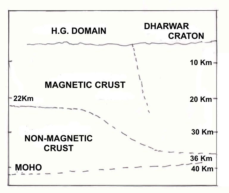
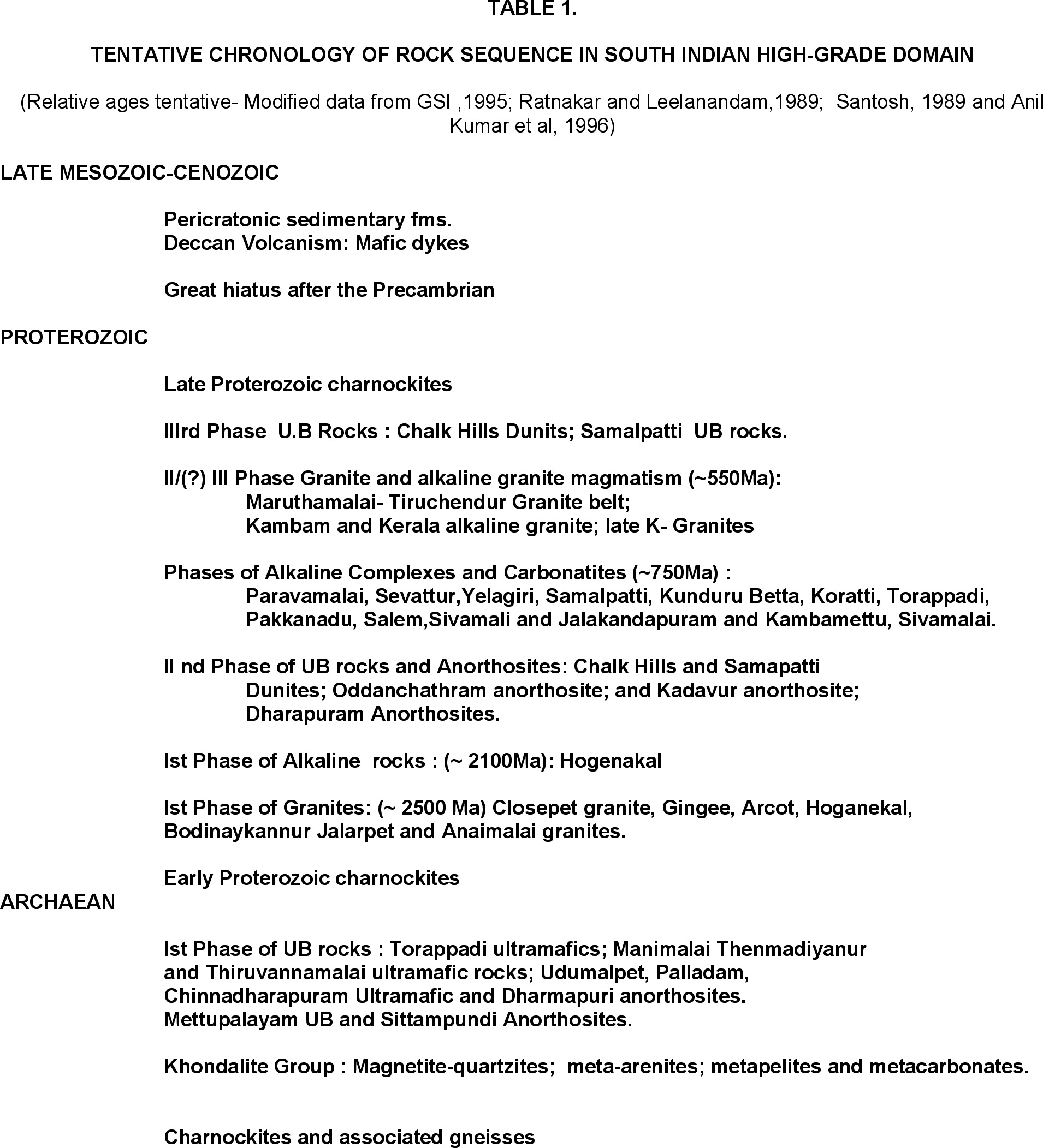
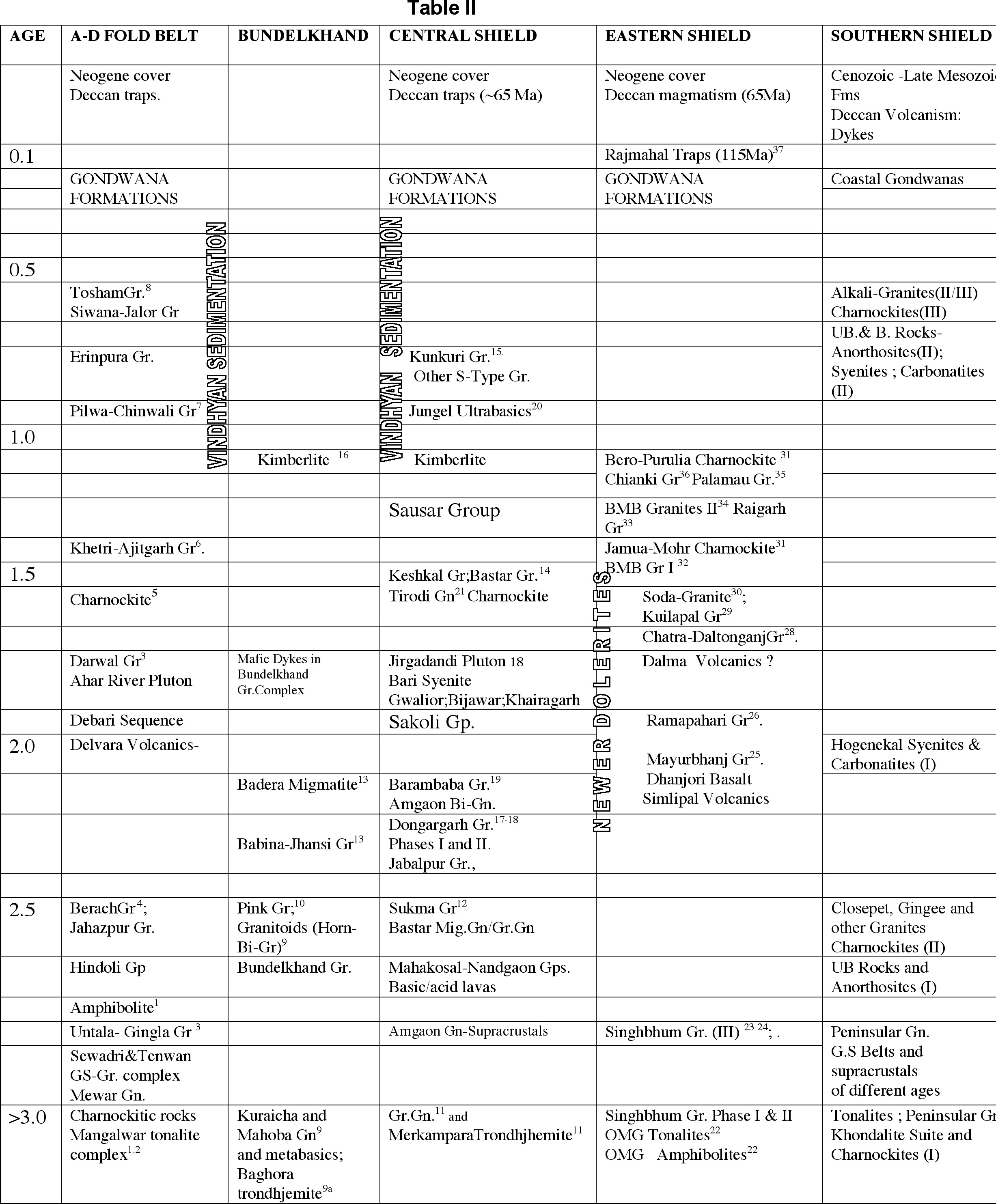