Lavecchia, G, Boncio, P, Creati, N, & Brozzetti, F. 2003. Some Aspects Of The Italian Geology Not Fitting With A Subduction Scenario Journal of the Virtual Explorer 10, 1-42.
Some Aspects Of The Italian Geology Not Fitting With A Subduction Scenario
Abstract
In this paper, we recall some aspects of the geology of central Italy, not fully consistent with the interpretation of the Tyrrhenian-Apennine system in the frame of a subduction context. Available near-vertical and deep-sounding seismic profiles across the Apennines of central Italy (e.g. CROP 03 and DSS ‘78) do not show any evidence of an accretionary wedge above a subducting plane, but rather show a thick-skinned thrust belt with involvement of the overall crust in the deformation and with modest amounts of horizontal shortening. The relatively deep (< 90 km) seismicity registered in Central Italy cannot be interpreted in terms of ongoing subduction. In fact, the hypocentral distributions do not mark the underthrusting of the Adriatic continental lithosphere beneath the Tyrrhenian lithosphere, but rather depict a seismogenic west-dipping thrust zone within the Adriatic lithosphere. The presence within the Apennine mountain chain of a carbonatite-potassic melilitite rock association, middle Pleistocene in age, points to a different geodynamic environment than subduction. In fact, this rock association is very rare and exclusively found in intra-continental rift context. The possibility to explain the evolution of the Tyrrhenian-Apennine system applying either a passive or an active (plume-related) rift context as alternative to subduction is briefly addressed. All considering, the evolution of the area is interpreted as the result of a peculiar combination of large-scale plume-induced lithospheric stretching and of local-scale rift push-induced crustal shortening, the latter progressively developed at the outer border of the extending region.
Keywords:
Tyrrhenian Sea, Apennines, extension, contraction, seismic lines, deep seismicity, carbonatites, subduction, plume.
Introduction
The Neogene-Quaternary Tyrrhenian-Apennine system of Italy may appear as a rather classic subduction-related geodynamic scenario. It exhibits a deep basin area (the Tyrrhenian Sea) inward of an E-verging fold-and-thrust belt system (the Apennines), a NW-dipping Benioff plane (offshore Calabria) and an active volcanic belt on the eastern border of the extended zone (Figure 1). Most of the scientific literature agrees with such an interpretation, although highly controversial models are proposed: flip of the subduction polarity from the Alpine E-dipping to the Apennine W-dipping and subsequent roll-back (Doglioni et al., 1998, 1999); with slab retreat of a W-dipping subduction plane (Scandone, 1980; Malinverno & Ryan, 1986; Royden et al., 1987; Brunet et al., 2000; Jolivet and Faccenna, 2000. Faccenna et al., 2001; Rosenbaum et al., 2002); along-strike slab detachment of a W-dipping subduction plane (Carminati et al., 1998; Van Der Meulen, 1998, 2000); ensialic compression proceeded by E-dipping subduction (Malavieille et al., 1998; Finetti et al., 2001); trech-arc-backarc migration driven by an extrusion process linked to the convergence of the Africa, Arabia and Eurasia plates (Mantovani et al., 2002).
A few voices out of the chorus have considered the chance to strongly subordinate the contraction to the extension and to look for a geodynamic model in which the Tyrrhenian extension is able to drive the Apennine fold-and-thrust belt development. Both active and passive rift models have been proposed (Locardi, 1982; Wezel, 1982; Lavecchia, 1988; Locardi and Nicolich, 1992; Vanossi et al., 1994; Lavecchia et al., 1995; Liotta et al., 1998). Supporting evidence of this point of view comes from geochemical and petrologic data concerning the occurrence of Ca-carbonatites and melilitites within the Apennine mountain chain (Lavecchia and Stoppa, 1996; Stoppa and Woolley, 1997; Lavecchia et al., 2002). These rocks are related to melts from the mantle and almost exclusively correlated to continental extension, being substantially incompatible with the high partial melt, which is necessarily associated with subduction (Woolley, 1989; Bailey, 1993; Baker, 1996; Bell et al., 1999).
In this paper, we do not intend to deal with the overall geodynamic problem associated with the evolution of the Tyrrhenian-Apennine system, but we rather wish to focus attention on some specific features, which, in our opinion, are not consistent with the subduction models. The features we will consider are: 1) - the deformation style at the crust scale of the central Apennine fold-and-thrust belt system; 2) - the link between the relatively deep seismicity of central Italy and a SW-dipping thrust zone cross-cutting the continental Adriatic lithosphere; 3) - the presence, within the Apennine mountain chain, of peculiar middle Pleistocene magmatic occurrences, ultra-alkaline in composition. To conclude, we will briefly consider if, in absence of subduction, either a passive or an active plume-related rift geodynamic scenario could be able to achieve the development of the Tyrrhenian-Apennine extensional-contractional pair.
Deformation Style
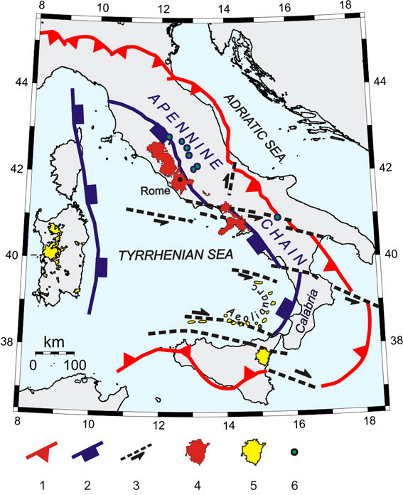
The Apennines of central Italy are located at the eastern side of the highly extended Tuscan zone and consists of late Miocene to Pleistocene thrust-and-fold structures with NE vergence (Figure 2). NW-SE to NNE-SSW striking contractional structures are crosscut by NNW-SSE striking alignments of late Pliocene-Pleistocene normal and normal-oblique faults. Thinned continental crust (20-25 km), positive gravity anomalies (0 to +50 mGal), generally low topographic elevation (mean value 260 m) and high Heat Flow Density (HFD) values (>80 mW/m2) are typical features of the Tuscan domain (Scarascia et al., 1994; Guzzetti and Reichenbach, 1994; Della Vedova et al., 2001). Thickened continental crust (35-40 km), negative gravity anomalies (0 to -50 mGal), generally high topographic elevation (mean value 900 m) and low HFD values (<50 mW/m2) are typical features of the Apennine domain. Normal continental crust (30 km), negative gravity anomalies (-50 mGal), generally low topographic elevation (mean value 195 m) and low HDF (~40 mW/m2) are typical features of the Adriatic domain.
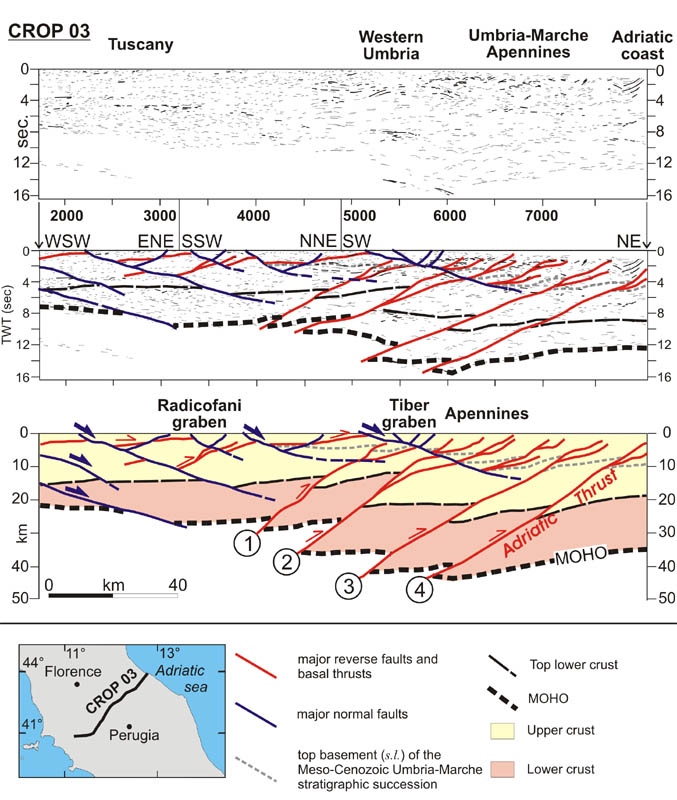
Information on the geometry of the crust and on the style of the deep crust deformation in central Italy are given by the CROP 03 seismic reflection profile (Barchi et al., 1998; Decandia et al., 1998; Finetti et al., 2001; Lavecchia et al., 2003) (Figure 3). Thinning of the crust in the Tuscan zone is achieved through a set of eastward-dipping and eastward-rejuvenating low-angle extensional shear zones, associated with antithetic west-dipping high-angle normal faults (Liotta et al., 1998; Boncio et al., 2000; Lavecchia et al., 2002).
Thickening of the crust in the Apennine zone is due to the development of an eastward-verging fold-and-thrust belt system. At upper crust levels, the contractional deformation consists in buckle folds and thrust structures deforming a Meso-Cenozoic carbonate multilayer (Bally et al., 1986; Lavecchia et al., 1987a; Lavecchia et al., 1987b). At depth, shortening is achieved through major SW-dipping thrusts which dislocate the entire crust, linking the sedimentary cover and the deep crust structures, according to a thick-skinned style of deformation (Barchi et al., 1998; Finetti et al., 2001). From western Umbria to the Adriatic Sea, the geological interpretation of the Crop 03 line-drawing (Figure 3) allows identifying different segments of the Moho, located at different depths, and likely belonging to distinct crustal slices that were sequentially overthrust one over the next. In particular, it is possible to identify four major basal thrusts, bounding at the base crustal slices corresponding to in-sequence and eastward rejuvenating contractional domains.
From west to east these domains are: A) the pre-Apennine domain, active from middle Serravallian to early Tortonian times (Brozzetti and Luchetti, 2002); B) the Umbria-Marche Apennine domain active between early Tortonian and early Pliocene times (Barchi et al., 1998); C) the pede-Apennine domain, active from late Messinian to middle Pliocene times (Calamita et al., 1990; Coward et al., 1999); D) the Coastal-Adriatic domain, whose activity starts with middle Pliocene times. Based exclusively on the interpretation from seismic lines, the activity of this domain seems to end with early Pleistocene times (Argnani and Frugoni, 1997; Calamita et al., 1999; Di Bucci and Mazzoli, 2002). Morphotectonic and seismological evidence well show that the domain has been also active during late Pleistocene-Holocene times and it is still active (Frepoli and Amato, 1997; Mariucci et al.,1999; Selvaggi et al., 2001; Vannoli et al., 2002; Lavecchia et al., 2003). The basal thrust of the Coastal-Adriatic domain (AT = Adriatic Thrust in figure 3) is the easternmost crust-scale discontinuity interpreted from the CROP 03 profile.
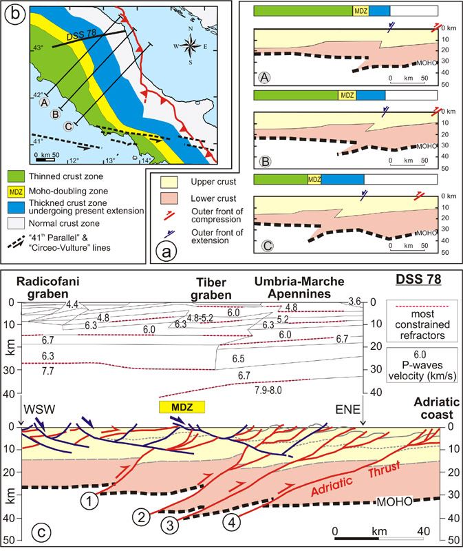
An important contribution to the knowledge of the geometry of the crust in Italy derives from deep seismic sounding (DSS) data (Scarascia et al., 1994; Morelli, 1994). A number of serial crustal sections across central Italy, constructed by Scarascia et al. (1998) by using gravimetric modelling of DSS data, clearly show that the overthrust of the thinned Tuscan crust (20-25 km) upon the “normal” to slightly thickened (35 km) Apennine crust is a regional feature (Figure 4a). The Tuscan and Apennine domains are parts of one original crust (the Adria crust) and a deep SW-dipping thrust is generally considered responsible for the doubling of the Moho (Nicolich, 2001). This geometry is particularly well evident along the Piombino-Ancona seismic refraction profile (DSS ’78, Ponziani et al., 1995), where, beneath the Tiber graben, the Tuscan Moho it overlaps the Apennine Moho for a length of about 25 km. A map view representation of the Moho doubling zone (MDZ) in central Italy is given in figure 4b. An interpretative geologic section along the trace of the DSS 78 profile is proposed in figure 4c; it is constrained by surface geologic data, commercial seismic lines and information deduced from the close near-vertical CROP 03 seismic reflection profile
The geometry and deformation style of the sections depicted in figures 3 and 4 is far from what is expected in a subduction zone. In fact, there is no trace of a frontal accretionary wedge made up of dragged upper layers of subducting lithosphere. The entire crust is involved in the fold-and-thrust belt structure with a thick-skinned style. The amount of linear shortening measured in the Umbria-Marche Apennines is very low: in the segment from Val Tiberina to the Adriatic Sea, the restored section of CROP 03 has a length of about 145 km with a linear shortening of about 45 km, i.e. about 30% of the total section length (Barchi et al., 1998). As also considered by other Authors (Doglioni et al., 1999), the total crustal area of the Apennines is less than the amount of the upper crust, which would have escaped subduction and would be added to the accretionary prism, considering the length of the Adriatic subducting lithosphere.
Thickness of the lithosphere
A thickness of less than 50 km for the seismic lithosphere of the Tuscany-western Latium domain and of ~100-110 km for the southern Adriatic foreland lithosphere is generally agreed on (Panza and Suhadolc, 1990). Controversial is the value beneath the central Apennine chain: a thickness of ~60 km is derived from the dispersion of surface-waves (Panza and Suhadolc, 1990), whereas a thickness of 100-150 km is derived from the P-waves analysis (Babuska and Plomerova, 1995).
An estimate of the thickness of the thermal lithosphere, defined by the depth at which the geotherm intersects the potential asthenosphere temperature (McKenzie and Bickle, 1988), is proposed by Lavecchia et al. (2002). Assuming a potential temperature of 1280°C (Cella and Rapolla; 1997; Federico and Pauselli, 1998), the Authors calculate depths of ~50 km, ~90 km and ~110 km for the lithosphere-asthenosphere boundary (LAB) beneath the RCP, the IUP and the Adriatic foredeep (ADF), respectively (Figure 5c). Then, along a transect corresponding to the trace of the DSS’78 profile, the topography of the base of the lithosphere is characterised by a sharp step between the thinned Tuscan and the unthinned Adriatic regions (Figure 5b). The strong differential lithospheric thinning may favour the development of local horizontal stresses in both the rifted and the unrifted regions (after Turcotte and Emerman, 1983). A simple quantitative estimate of the horizontal force generated at the Tuscan rift is given by Lavecchia et al. (1995); the Authors computed a maximum rift push force of 7·1011N/m. This value is comparable with the value of the shearing force, about 6.2·1011 N/m, computed by Marson et al. (1998) in order to allow the flexure of the Adriatic crust beneath the outer Apennine zone (e.g. the Apennine crust thickening). Then, although the Apennine topographic load is not sufficient to justify the flexure of the Adriatic crust (Royden et al., 1987), it is not necessary to invoke a westward-dipping and sinking Adriatic slab in order to produce the necessary extra load (Decandia et al., 1998; Liotta et al., 1998).
Relatively Deep Seismicity
Since about the early nineties, the occurrence of relatively deep (20 to 90 km) small-to-moderate (M<5.5) earthquakes, with prevailing reverse and oblique solutions, has been highlighted in the northern Apennines of Italy (Selvaggi and Amato, 1992; Selvaggi, 2001; Ferretti et al., 2002) (Figure 6). These earthquakes are commonly considered as evidence for the active subduction of the Adriatic continental lithosphere beneath the Apennines (Mariucci et al., 1999; Meletti et al., 2000; Amato and Cimini, 2001; Parolai et al., 2001). Alternatively, some Authors have interpreted the deep seismicity as independent from subduction, being either considered few and not spatially organized (Di Bucci and Mazzoli, 2002) or attributed to deformation of an active thrust fault within the Adriatic lithosphere (Collettini et al., 1997; Finetti et al., 2001; Lavecchia et al., 2003). When comparing the epicentral distributions of the deep seismicity with the plane view of the Moho Doubling Zone (MDZ), it is evident that the deep events cannot be associated to subduction. (Figure 6). In fact, in the frame of a subduction model, the MDZ is considered to mark the underthrusting of the Adriatic lithosphere beneath the Tyrrhenian lithosphere (Ponziani et al., 1995), and consequently the deep events would be located near or to the west of MDZ. On the contrary, they are almost exclusively located eastward of MDZ.
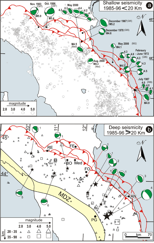
The epicentral distribution of the deep events has an eastward convex arch shape that recalls that of the Coastal-Adriatic upper crust contractional seismicity, as well as that of the Adriatic front, e.g. the surface trace of the Adriatic thrust (AT). Lavecchia et al. (2003) have compared the down-dip geometry of the AT with the depth-distribution of shallow and deep well-located minor seismic events occurring within a half-width of 30 km along the trace of the DSS’78 profile. Analyzed data allow the Authors to state that the AT is presently undergoing deformation (Figure 5b): the brittle deformation is concentrated preferentially within the upper crust (<10 km) and within the uppermost lower crust (15 to 25 km). Less frequent earthquakes also occur at larger depths, specifically close to the crust-mantle boundary (35 to 45 km) and within the mantle lithosphere (55 to 70 km).
Down to a depth of about 45-50 km, the AT down-dip mechanical layering, reconstructed by yield strength envelope, fits the earthquake distribution. At larger depths, the deformation mechanism is dominated by plastic flow which is expected to be almost aseismic. Nevertheless, a strong correlation between the subcrustal hypocenter pattern and the deep geometry of the AT shear zone is observed to a depth of about 70 km.
The deepest events (55 to 70 km) might represent seismic plastic instabilities caused by high strain concentrations along the AT intra-mantle prosecution (Hobbs et al., 1986). This hypothesis is likely, considering that instabilities leading to seismic events are predicted to occur within the mantle during plastic shearing in thrust regime, provided the shear stress is relatively high (~100-200 MPa) and the geothermal gradient relatively low (≤20°C/km) (Ord and Hobbs, 1989). Furthermore, we must consider that a peculiar increase in pore fluid pressure capable to reduce the strength dramatically (Artyushkov and Morner, 1998; Déverchère et al., 2001) might characterise the mantle beneath central Italy, due to its extremely high concentration of hydroxil-CO2 rich volatiles (Chiodini et al., 1999).
In conclusion, the AT is interpreted as a still active SW-dipping lithospheric-scale thrust zone sited at the outer front of the Northern Apennines. It is responsible for both the shallow seismicity of the Marche coastal and adjacent off-shore region and for the intermediate-depth seismicity beneath the Apennines. It is worthily to note in figure 5b, as the cut-off depth of the seismicity beneath the central Apennines (~75 km) just corresponds with the depth of the intersection between the LAB and the intra-mantle prosecution of the Adriatic thrust, confirming that the Adriatic lithosphere does not penetrate within the Tyrrhenian asthenosphere.
Ultra-Alkaline Magmatism
Peninsular Italy is characterized by the presence of a rare magmatic rock association that includes Ca-carbonatites, peralkaline melilitites and other mafic ultra-alkaline rocks (Stoppa and Lavecchia, 1992; Lavecchia and Stoppa, 1996; Stoppa and Woolley, 1997; Lavecchia et al., 2002). The Italian carbonatite-melilitite rocks have ages ranging from ~0.65 to ~0.13 Ma and are distributed within the Umbria-Marche-Abruzzo and Lucania Apennines and constitute the Intramontane Ultra-alkaline Province (IUP, Figure 1). Very high values of the Mg# (69<Mg2+/Mg2++Fe2+<92) together with a strong enrichment in large-ion-lithophile elements (LILE) and a minor enrichment in high-field-strength elements (HFSE) are common IUP features. 87Sr/86Sr and 143Nd/144Nd range from 0.7100 to 0.7112 and from 0.5119 to 0.5121, respectively; all occurrences contain mantle debris consisting of discrete mantle nodules and xenocrysts of olivine, pyroxene and phlogopite characterised by high Mg, Ni and Cr contents.
The IUP is positioned ~50 km to the east of the co-axial and almost coeval Roman Co-magmatic Province (RCP) (Figure 1); it shares important geological and petrologic features with the leucite-bearing lavas of the RCP (so-called High-Potassium Series, HKS). Phlogopite and carbonate are essential constituents of both the IUP and HKS and suggest that the near solidus melt of a carbonate/phlogopite-bearing peridotite would yield melts of appropriate chemistry (Bailey and Collier, 2000).
The extremely high concentration of incompatible elements and radiogenic Sr is present in both the carbonatite-melilitites and the HKS, thus requiring a highly metasomatised “enriched” and radiogenic source for their generation. Most commonly, this source has been related to contamination with a sedimentary component derived from subduction of the Adriatic continental lithosphere (Civetta et al., 1989; Peccerillo, 1985, 1999; Vollmer, 1989; Conticelli and Peccerillo, 1992; Serri et al., 1993). Alternatively, it has been interpreted in a rift context (Cundari, 1979, 1994; Locardi, 1986; Stoppa and Lavecchia, 1992). In our opinion, this second hypothesis sounds particularly interesting in consideration of the close similarity in magmatic features (major- and trace-element characteristics), volcanic style (form and dimensions of centres) and composition of the mantle source (phlogopite-bearing carbonate) between the IUP and the world-wide famous carbonatite province of Uganda (East-African Rift System) (Bailey and Collier, 2000). This similarity points to a suitable source for IUP-type melts, which does necessarily involve subduction and upper crust contamination. Carbonates are certainly not present in the basement rocks of the Ugandan occurrences and subduction processes have not been active since at least 500±150 Ma (Pan African orogeny, Ashwal and Burke, 1989).
Similar or even higher Sr and lower Nd isotopic ratios than those of Italian carbonatites have also been obtained from micaceous kimberlites and lamproites from West Australia and South Africa, which were considered to reflect an enriched mantle source and not a crustal contamination (Mitchell and Bergman, 1991). High Sr and low Nd isotopic values are typical of cratonic igneous rocks such as lamproites and kimberlites and may be related to an ancient reservoir within the mantle completely unrelated to subduction. In general, a large amount of partial melting, typical of subduction-related environments is in contrast with the extremely low degree of partial melting required for carbonatite melt generation.
In the particular case of Italy, the IUP metasomatism cannot be related to fluids deriving from the west-dipping Adriatic plate, because some of the occurrences (those at Mt. Vulture) are situated east of the hinge axis of the subduction plane. Furthermore, the extreme undersaturated SiO2 and very high Mg# of the IUP rocks rule out any physical dilution with crustal material. The IUP and the HKS products have been associated to subduction also because of their negative contents in Ta-Nb, Zr-Ti and Eu, which are considered typical of upper crust material (Peccerillo, 1999 and references therein). In reality, these anomalies cannot be taken as a tectonic discriminator as they are also observed in intra-continental rift volcanoes such the Oldoynio Lengay and the Kerimasi in the western branch of the East African Rift system (Church and Jones, 1995). Out of a subduction context, the melting processes that led to the generation of IUP and RCP may be simply linked to the Tyrrhenian rift process and to the associated thinning and stretching of the continental lithosphere, with asthenosphere unloading and upwelling (Lavecchia and Stoppa, 1996). A volatile-enriched asthenospheric mantle, fed by radiogenic fluids coming from the boundary layer between the upper and the lower mantle or from deeper would well retain a composition suitable for the HKS and IUP parental melts (Lavecchia et al., 2002).
Based on a wide and regional geochemical-isotopic data base, Bell et al. (2001, in print) suggest to associate the IUP and, more in general the Italian magmatism and recent tectonics, to a mantle plume, sited beneath central Italy.
Passive Rift Verses Active Rift
It is largely accepted in the geological literature, that, with the beginning Oligocene times, the process of convergence between the European and African plates, leading to subduction of the Tethyan oceanic lithosphere and to the build up of the Alpine chain, had reached an end (Faccenna et al., 2003 and therein references). At that point, the tectonic scenario was dominated by the western Mediterranean rift process and by the nucleation of the Apennine fold-and-thrust belt system. Based on the points previously discussed in the paper and also considering that the E-W extensional process shaping the Mediterranean has about eight times higher importance than the N-S Africa-Europe convergence (Doglioni et al., 1999 among many), we wonder if it is more reasonable to consider a geodynamic model that subordinates the contraction to the extension and not vice versa. In such a case, another question arises: “In absence of subduction, would the birth and growth of the Tyrrhenian-Apennine system be better interpreted in the frame of a passive rift context or of a plume-controlled active rift context?”.
In our opinion, the impingement of a hot plume on the base of the Tyrrhenian lithosphere is incompatible with the tectonic setting and geometric features of the system (Cella and Rapolla, 1997; Lavecchia et al., 2002). In fact, the time-space relationships between rifting and volcanism (Neogene volcanism accompanied and post-dated normal faulting), the absence of evidence of an abnormally high temperature at the lithosphere-asthenosphere boundary (Tp around 1280° C and small erupted volumes of mafic magmas), the large extensional strain rate (10-15 s-1) and most of all the elevated amount of crustal stretching (factor beta up to 3.5-4) are rather typical of passive rift. On the other hand, a passive rift process capable to drive the opening of the Tyrrhenian basin would imply a prevailing ESE motion of the Adria lithosphere with respect to stable Europe, but this does not fit with large-scale plates motion. Since late Cretaceous times, the motion of Africa relative to Europe has always been converging and NW to N-oriented (Faccenna et al., 2003 and references therein).
Following Lavecchia and Creati (in print), we suggest that the above problems might be overcome, if we do not consider a stationary plume impinged beneath the lithosphere, but a fast, eastward moving, plume trapped within the transition zone (between the 410- and 670- km phase boundaries) and arising from the core-mantle interface (D’’ boundary layer). The asymmetric growth of the plume head plume would be controlled by the large-scale circulation of the upper mantle and would induce the progressive east-south-eastward motion of the asthenospheric volume, with consequent stretching and thinning of the overlying lithosphere. Rift push forces generated at the eastern side of the extending system, due to the strong differential thinning between the Tyrrhenian and Adriatic regions, would achieve a process of lateral material accommodation responsible for the nucleation of the Apennine fold-and-thrust belt structures. Metasomatizing fluids, retaining the geochemical and isotopic Sr-Nd-Pb signatures of D’’ core-mantle boundary layer, would be released by the plume head in the uppermost asthenosphere, thus determining the very peculiar and rare composition of the mantle source region of the recent Italian HK-alkaline and carbonatitic to K-melilitic magmatism.
In order to predict the size of such a plume along a regional transect from Provençe to the Adriatic Sea, we apply a simple area balance methodology (Figure 7). The method is based on the asumption of an equivalence between the area of the plume head that enters within the transition zone and the area of the asthenosphere that is pushed laterally. The eastward-expanding asthenosphere drives the stretching of the overlying lithosphere and, therefore, the amount of finite lithospheric extension (_l=lfinal-linitial) is a direct expression of the amount of lateral asthenospheric expansion. The finite extension (_l) calculated along the Provençe-Adriatic Sea transect is about 100 km (Brozzetti et al., in prep.). Then, assuming a depth of 670 km for the asthenosphere-mesosphere boundary (AMB), the area occupied by the crust and upper mantle region in correspondence of the Dl segment would be equal to Dl multiplied by AMB, that is about 67.000km2. In the sketch in figure 7, almost the same area is occupied by the plume head within the transition zone. The shape of the plume draws inspiration from the geometry of plumes trapped in the transition zone numerically modelled by Brunet and Yen (2000).
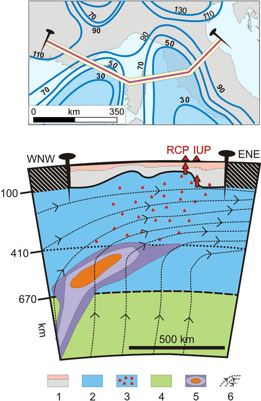
A major problem that the plume model meets is the tomographic velocity pattern detected in the Mediterranean region, that shows a large-scale high-velocity anomaly placed in the transition zone coupled with a large-scale low-velocity anomaly in the uppermost asthenosphere (Faccenna et al., 2003 and references therein). In order to reconcile the tomographic images with the trapped plume model, it is necessary to suppose that the velocity pattern reflects chemical rather than thermal anomalies. The fast zones, within the transition zone, would represent a highly depleted and dehydrated plume head which has lost volatiles and fluids during upwelling. In turn, the overlying low-velocity zone might represent an asthenospheric region metasomatised and enriched by H2O-CO2 rich fluids and volatiles released by the plume head.
Final Comment
In our opinion, it is evident that the present geometry of the crust and mantle lithosphere, the contraction-extension pair, the relatively deep seismicity and the ultra-alkaline magmatism in central Italy do not need to be an expression of a subduction process. Also considering the growing geochemically-based evidence of a plume-related magmatic activity in Italy (Bell et al., 2001; Gasperini et al., 2002; Bell et al., in print.), we suggest that the Neogene to Quaternary tectonic history and the present geometry of the Tyrrhenian-Apennine system are the result of a peculiar combination of plume-induced lithospheric stretching and of consequently developed local rift push forces. In the frame of such a model, the rigid cold body evidenced within the Tyrrhenian asthenosphere by the deep seismicity offshore Calabria (Amato and Cimini, 2001; Piromallo and Morelli, 2003) would represent a remnant of the pre-existing east-dipping Alpine subduction plane.
Acknowledgements
This paper was supported by Ud’A University research grants to G. Lavecchia. We thank Gideon Rosenbaum for kindly reviewing the English of an earlier version of the manuscript.
References
- Amato, A., & Cimini, G.B., 2001. Deep structure from seismic tomography. In :Anatomy of an Orogen: The Apennines and adjacent Mediterranean Basins, V. Eds: Vai G.B. and Martini I.P. (Eds.), Kluwer Academic Publishers: 33-45.
- Argnani, A. & Frugoni, F., 1997. Foreland deformation in the central Adriatic and its bearing on the evolution of the Northern Apennines. Geodynamics of the Mediterranean region and its implications for seismic and volcanic risk. Annali di Geofisica, 40: 771-780.
- Artyushkov, E.V. and Corner, N.A., 1998. Steep bending of the continental lithosphere without its stretching or plate collision: an indication for lithospheric failure and phase transitions. Terra Nova, 10: 101-105.
- Ashwal, L.D. & Burke, K., 1989. African lithospheric structure, volcanism and topography. Earth and Planetary Science Letters, 96: 8-14.
- Babuska, V. & Plomerova, J., 1995. Tomographic studies of the upper mantle beneath the Italian region. Terra Nova, 2: 569-576.
- Baker, D.S., 1996. Carbonatite volcanism. In: Mitchell R.H. Ed., Undersaturated Alkaline Rocks: Mineralogy, Petrogenesis, and Economic Potential. Mineralogical Association of Canada, Short Course, 24: 45-61.
- Bailey, D.K. 1993. Carbonate magmas. Journal of Geological Society, London, 150: 637-651.
- Bailey, D.K. & Collier, J.D., 2000. Carbonatite-melilite association in the Italian collision zone and Ugandan rifted craton: significant common factors. Mineralogical Magazine, 64: 675-682.
- Bally, A.W., Burbi, L., Cooper, C. and Ghelardoni, R., 1986. Balanced sections and seismic reflection profiles across the central Apennines. Memorie della Società Geologica Italiana, 35: 257-310.
- Barchi M., Minelli, G. and Pialli G., 1998. The Crop 03 profile: a synthesis of result on deep structures of the northern Apennines. Memorie della Società Geologica Italiana, 52: 383-400.
- Bell, K., Castorina, F., Rosatelli, G. & Stoppa, F., 2004. Plume activity, magmatism and the geodynamic evolution of the central Mediterranean. Annal. Geophys., in press.
- Bell, K., Castorina, F. & Stoppa, F. 2001. Isotopic regional zoning versus tectonic polarity in Pleistocene leucitites, melilitites and carbonatites of the Italian peninsula. European Union of Geosciences, April 8 - 12 (abstract volume).
- Bell, K., Kjarsgaard, B.A. & Simonetti, A., 1999. Carbonatites into the twenty-first century. Journal of Petrology, 39, 1839-1845.
- Boncio, P., Brozzetti, F. & Lavecchia G., 2000. Architecture and seismotectonics of a regional low-angle normal fault zone in central Italy. Tectonics, 19: 1038-1055.
- Borraccini, F., De Donatis, M., Di Bucci, D., Mazzoli, S., Megna, A., Nesci, O., Santini, S., Savelli, D., Tramontana, M. & Triggiani, P. 2002. Analisi della tettonica quaternaria nel basso bacino del fiume Metauro (Marche settentrionale) e nell’adiacente offshore adriatico attraverso l’integrazione di dati sismici, geodinamici, stratigrafici e strutturali. Studi Geogici Camerti, 2: 29-44.
- Brozzetti, F., Lavecchia, G. & Creati, N., 2004. Tectonic style, areal balancing and timing of the deformation along the lithospheric Cote d’Azur-Adriatic sea transect. In preparation.
- Brozzetti, F. & Luchetti, L., 2002. Stratigraphic constraints to the tectonic evolution of the Miocene foredeep in northern Apennines Italy. Atti, III Seminario di cartografia geologica 26-27 Febbraio 2002 Bologna, in press.
- Brunet, C., Monié, P., Jolivet, L.. & Cadet, J.P., 2000. Migration of compression and extension in the Tyrrhenian Sea, insights from 40Ar/39Ar ages on micas along a transect from Corsica to Tuscany. Tectonophysics, 321: 127-155.
- Brunet, D. & Yuen, D., 2000. Mantle plumes pinched in the transition zone, Earth Plan. Science Letters, 178: 13-27.
- Calamita, F., Coltorti, M., Pieruccini, P. & Pizzi, A., 1999. Evoluzione strutturale e morfogenesi plio-quaternaria dell'Appennino umbro-marchigiano tra il pre-Appennino umbro e la costa adriatica. Bollettino della Società Geologica Italiana 118: 125-139.
- Calamita, F., Cello, G., Invernizzi, C. & Paltrinieri, W., 1990. Stile strutturale e cronologia della deformazione lungo la traversa M.S. Vicino – Polverigi (Appennino marchigiano esterno). Studi Geologici Camerti, Volume Speciale (1990): 69-86.
- Carminati, E., Wortel, M.J.R., Spakman, W. & Sabadini, R., 1998. The role of slab detachment processes in the opening of the western-central Mediterranean basins: some geological and geophysical evidence. Earth and Planetary Sciences Letters, 160: 651-665.
- Cella, F. & Rapolla, A., 1997. Density changes in upwelling mantle. Physics of the Earth and Planetary Interior, 103: 63-84.
- Chiodini, G., Frondini, F., Kerrick, D.M., Rogie, J., Parello, F., Peruzzi, L. & Zanzari, A.R., 1999. Quantification of deep CO2 fluxes from Central Italy. Examples of carbon balance for regional aquifers of soil diffuse degassing. Chemical Geology, 159: 205-222.
- Church, A. C. & Jones, A. P., 1995. Immiscibile textures in the 1993 natrocarbonatite lavas from Oldoinyo Lengai, Tanzania. Journal of Petrology, 36: 869-889.
- Civetta, L., Francalanci, L., Manetti, P. & Peccerillo, A., 1989. Petrological and geochemical variation across the Roman Comagmatic Province: inference in magma genesis and crustal-mantle evolution. In: The Lithosphere in Italy. Advances in Earth Science Research, Boriani A., Bonafede M., Piccardo G.B. and Vai G.B. (Eds.), The Lithosphere in Italy. Advances in Earth Science Research, Accademia. Naz.ionale dei Lincei, Rome: 183-199.
- Collettini, C., Boncio, P., La vecchia, G., Ponziani, F. & Federico, C., 1997. Sismicità “profonda” e geometria delle deformazioni intra-litosferiche in Italia centrale. Atti XVI Convegno GNGTS, AIT-CDRom 1997.
- Conticelli, S. & Peccerillo, A., 1992. Petrology and geochemistry of potassic and ultrapotassic volcanism in central Italy: petrogenesis and inferences on the evolution of the mantle source. Lithos, 28: 221-240.
- Coward, M. P., De Donatis, M., Mazzoli, S., Paltrinieri, W. & Wezel, F. C. ,1999. Frontal part of the Northern Apennines fold and thrust belt in the Romagna-Marche area Italy; shallow and deep structural styles. Tectonics, 18: 559-574.
- Cundari, A., 1994. Role of subduction in the genesis of potassic rocks: a discussion paper on the unfashionable side of the role. Mineralogica et Petrographica Acta, 37: 81-90.
- Cundari, A., 1979. Petrogenesis of leucite-bearing, lavas in the Roman volcanic region, Italy; the Sabatini lavas. Contribution to Mineralogy and Petrology: 70, 9-21.
- Decandia, A.F., Lazzarotto, A., Liotta, D., Cernobori, L. & Nicolich, R., 1998. The Crop 03 traverse: insights on post-collisional evolution of northern Apennines. Memorie della Società Geologica Italiana, 52: 427-439.
- Della Vedova, B., Bellini, S., Pellis, G. & Squarci P., 2001. Deep temperatures and surface heat flow distribution. In: Anatomy of an orogen: the Apennines and adjacent Mediterranean basins, G. Vai and P. Martini (Eds.), Anatomy of an orogen: the Apennines and adjacent Mediterranean basins. Kluwer: 65-76.
- Déverchère, J., Petit, C., Gileva, N., Radziminovitch, N., Melnikova, V. & San’kov, V., 2001. Depth distribution of earthquakes in the Baikal rift system and its implications for the rheology of the lithosphere. Geophysical Journal International, 146: 714-730.
- Di Bucci, D. & Mazzoli, S., 2002. Active tectonics of the Northern Apennines and Adria geodynamics: new data and discussion. Journal of Geodynamics, 34: 687-707.
- Doglioni, C., Mongelli, F. & Pialli, G. 1998. Boudinage in the Alpine belt in the Apenninic back-arc, Memorie della Società Geologica Italiana, 52: 457-468.
- Doglioni, C., Gueguen, E., Harabaglia, P. & Monelli, F., 1999. On the origin of west-directed subduction zones and applications to the western Mediterranean. In: B. Durand, L. Jolivet, F. Horvath and M. Seranne Eds., The Mediterranean Basins: Tertiary Extension within the Alpine Orogen, B. Durand, L. Jolivet, F. Horvath and M. Seranne (Eds.),. Geological Society of London Special Publication, 156: 541-561.
- Faccenna, C., Jolivet, L., Piromallo, C. & Morelli, A., 2003. Subduction and depth of convection in the Mediterranean mantle. Journal of Geophysical Research, 107: 1-13
- Faccenna, C., Funiciello, F., Giardini, D. & Lucente, P., 2001. Episodic back-arc extension during restricted mantle convection in the Central Mediterranean. Earth and Planetary Science Letters, 187: 105-116.
- Federico, C. & Pauselli, C., 1998. Thermal evolution of the Northern Apennines Italy. Memorie della Società Geologica Italiana, 52: 267-274.
- Ferretti, G., Solarino, S. & Eva, E. 2002. Crustal structure of the Lunigiana-Garfagnana area (Tuscany, Italy): seismicity, fault plane solutions and seismic tomography. Bollettino di Geofisica Teorica ed Applicata, 43(3-4): 221-238.
- Finetti, I.R., Boccaletti, M., Bovini, M., Del Ben, A., Geletti, R., Pipan, M. & Sani, F., 2001. Crustal section based on CROP seismic data across the North Tyrrhenian-Northern Apennines-Adriatic Sea. Tectonophysics, 343: 135-163.
- Frepoli, A. & Amato, A., 1997. Contemporaneous extension and compression in the Northern Apennines from earthquake fault plane solution. Geophysical Journal International, 129: 368-388.
- Gasparini, C., Iannaccone, G., & Scarpa, R., 1985. Fault-plane solutions and seismicity of the italian peninsula. Tectonophysics, 117: 59-78.
- Gasperini, D., Blichert-Toft, J., Bosch, D., Del Moro, A., Macera, P. , Telouk, P. & Albarede, F., 2002. Upwelling of deep mantle material through a plate window: Evidence from the geochemistry of Italian basaltic volcanics. Journal of Geophysical Research, 107: 2367-2371.
- Guzzetti, F. & Reichenbach, P., 1994. Towards a definition of topographic divisions for Italy. Geomorphology, 11: 57-74.
- Hobbs, B.E., Ord, A. & Teyssier, C., 1986. Earthquakes in the ductile regime? Pure and Applied Geophysics, 124: 309-336.
- ING-GNDT-Gruppo di lavoro Catalogo strumentale 2001. Catalogo strumentale dei terremoti italiani dal 1981 al 1996, versione 1.0 CD-ROM.
- Jolivet, L. & Faccenna, C., 2000. Mediterranean extension and the Africa-Eurasia collision. Tectonics, 19: 1095-1106.
- Lavecchia, G. 1988. The Tyrrhenian-Apennines system: structural setting and seismotectogenesis. Tectonophysics, 147: 263-296.
- Lavecchia, G. & Creati, N., 2004. A mantle plume pinched in the transition zone beneath the Mediteranean : a preliminary idea. Annal. Geophys. In press
- Lavecchia, G. & Stoppa, F., 1996. The tectonic significance of Italian magmatism: an alternative view to the popular interpretation. Terra Nova, 8: 435-446
- Lavecchia, G., Boncio, P. & Creati, N., 2003. A lithospheric scale thrust zone as an explanation for the relatively deep seismicity of central Italy. Journal of Geodynamics, 36: 79-94.
- Lavecchia, G., Creati, N. & Boncio, P., 2002. The Intramontane Ultra-alkaline Province IUP of Italy: a brief review with considerations on the thickness of the underlying lithosphere. Bollettino della Società Geologica Italiana, special volume 1: 87-98.
- Lavecchia, G., Minelli, G. & Pialli, G., 1987a. Contractional and extensional tectonics along the transect Lake Trasimeno-Pesaro Central Italy. In: Boriani et al.EDS, The Lithosphere in Italy Advances in Earth Science Research. Italian Mid-Term Conference on the Lithosphere Program. Rome, 5-6 May 1987. Atti Convegno dei Lincei, 80: 177-194.
- Lavecchia, G., Minelli, G., & Pialli, G., 1987b. The Umbria-Marche arcuate fold-belt. Tectonophysics, 146: 125-137.
- Lavecchia, G., Federico, C., Stoppa, F. & Karner, G.D. ,1995. La distensione tosco-tirrenica come possibile motore della compressione appenninica. Studi Geologici Camerti, volume speciale 1995/1: 489-497.
- Liotta, D., Cernobori L. & Nicolich, R., 1998. Restricted rifting and its coexistence with compressional structures: results from the Crop 03 traverse Northern Apennines, Italy. Terra Nova, 10: 16-20.
- Locardi, E., 1982. Individuazione delle strutture sismogenetiche dall’esame dell’evoluzione vulcano-tettonica dell’Appennino e del Tirreno. Memorie della Società Geologica Italiana, 24: 569-596.
- Locardi, E., 1986. Tyrrhenian volcanic arcs: volcanotectonics, petrogenesis and economic aspects. In: Wezel F.C. ed., The Origin of the Arcs, Amsterdam: 351-373.
- Locardi, E. & Nicolich, R., 1992. Geodinamica del Tirreno e dell’Appennino centro-meridionale: la nuova carta della Moho. Memorie della. Società Geologica Italiana, 41: 121-140.
- Malavieille, J., Chemenda, A. & Larroque, C., 1998. Evolutionary model for Alpine Corsica: mechanism for ophiolite emplacement and exhumation of high-pressure rocks. Terra Nova, 10: 317-322.
- Malinverno, A. & Ryan, W.B.F., 1986. Extension in the Tyrrhenian Sea and shortening in the Apennines as result of arc migration driven by sinking of the lithosphere, Tectonics, 5: 227-245.
- Mantovani, E., Albarello, D., Babbucci, D., Tamburelli, C. & Viti, M., 2002. Trench-Arc-Back-Arc system in the Mediterranean area: examples of extrusion tectonics. Journal of the Virtual Explorer, 8: 125-141.
- Mariucci, M. T., Amato, A. & Montone, P., 1999. Recent tectonic evolution and present stress in the Northern Apennines Italy. Tectonics, 18: 108-118.
- Marson, I., Cernobori, L., Nicolich, R., Stoka, M., Liotta, D., Palmieri, F. & Velicogna, I., 1998. Crop 03 profile:a geophysical analysis of data and results. Memorie della Società Geologica Italiana, 52: 123-137.
- McKenzie, D. & Bickle, M. J., 1988. The volume and composition of melt generated by extension of the lithosphere. Journal of. Petrology, 29: 625-679.
- Meletti, C., Patacca, E. & Scandone, P., 2000. Construction of a seismotectonic model: the case of Italy. Pure Applied Geophysics, 157: 11-35.
- Mitchell, R.H. & Bergman, S.C., 1991. Petrology of lamproites. Plenum Publishing Corporation, New York: 447 pp.
- Morelli, C., 1994. Current knowledge on the crustal properties of Italy. Annali di Geofisica, 37: 1113-1130.
- Mueller, B., Reinecker, J., Heidbach, O. & Fuchs, K., 2000. The 2000 release of the World Stress Map (available online at www.world-stress-map.org).
- Nicolich, R., 2001. Deep Seismic Transects. In: Vai, G.B., Martini, P., (Eds), Anatomy of an Orogen: the Apennines and Adjacent Mediterranean Basins. Kluwer Acad. Publishers: 47-52.
- Ord, A. & Hobbs, B.E., 1989. The strength of the continental crust, detachment zones and the development of plastic instabilities. Tectonophysics, 158: 269-289.
- Panza, G.F. & Suhadolc, P., 1990. Properties of the lithosphere in collisional belts in the Mediterranean:. a review. Tectonophysics, 182: 39-46.
- Parolai, S., Trojani, L., Monachesi, G., Frapiccini, M., Cattaneo, M. & Augliera, P., 2001. Hypocenter location accuracy and seismicity distribution in the Central Apennines Italy. Journal of. Seismology, 5: 243-261.
- Pasquale, V., Verdoya, M, Chiozzi, P. & Ranalli, G., 1997. Rheology and seismotectonic regime in the northern central Mediterranean. Tectonophysics, 270: 239-257.
- Peccerillo, A. 1999. Multiple mantle metasomatism in central-southern Italy: geochemical effects, timing and geodynamic implications. Geology, 27: 315-318.
- Peccerillo, A. 1985. Roman Comagmatic province: Evidence for subduction.-related magma genesis. Geology, 13: 103-106.
- Piromallo, C. & Morelli, A., 2003. P wave tomography of the mantle under the Alpine-Mediterranean area. Journal of Geophysical Research, 108 (B2), 2065, doi:10.1029/2002JB001757.
- Ponziani, F., De Franco, R., Minelli, G., Biella, G., Federico, C. & Pialli, G., 1995. Crustal shortening and duplication of the Moho in the Northern Apennines: a view from seismic refraction data. Tectonophysics: 252, 391-418.
- Riguzzi, F., Tertulliani, A. & Gasparini, C., 1989. Study of the seismic sequence of Porto San Giorgio (Marche) – 3 July 1987. Nuovo Cimento, 12: 453-465.
- Royden, L., Patacca, E. & Scandone, P., 1987. Segmentation and configuration of subducted lithosphere in Italy: an important control on thrust belt and foredeep-basin evolution. Geology, 15: 714-717.
- Rosenbaum, G., Lister, G. S. & Duboz, C., 2002. Reconstruction of the tectonic evolution of the western Mediterranean since the Oligocene. Journal of Virtual Explorer, 8: 107-126.
- Scandone, P. 1980. Origin of the Tyrrhenian Sea and Calabrian arc. Bollettino della Società Geologica Italiana, 98: 27-34.
- Scarascia, S., Cassinis, R. & Federici, F., 1998. Gravity modelling of deep structures in the Northern-Central Apennines. Memorie della Società Geologica Italiana, 52: 231-246.
- Scarascia, S., Lozej, A. & Cassinis, R., 1994. Crustal structures of the Ligurian, Tyrrhenian and Ionian Seas and adjacent onshore areas interpreted from wide-angle seismic profiles. Bollettino di Geofisica Teorica Applicata, 36: 141-144.
- Selvaggi, G. 2001. Strain pattern of the Southern Tyrrhenian slab from moment tensors of deep earthquakes: implications on the down-dip velocity. Annali di Geofisica, 41: 155-165.
- Selvaggi, G. & Amato, A., 1992. Subcrustal earthquakes in the Northern Apennines Italy: evidence for a still active subduction? Geophysical Research Letters, 19: 2127-2130.
- Selvaggi, G., Ferulano, F., Di Bona, M., Frepoli, A., Azzara, R., Basili, A., Chiarabba, C., Ciaccio, M.G., Di Luccio, F., Lucente, F.P., Margheriti, L. & Del Nostro, C., 2001. The Mw 5.4 Reggio Emilia 1996 earthquake: active compressional tectonics in the Po Plain, Italy. Geophysical Journal International 144: 1-13.
- Serri, G., Innocenti, F. & Manetti, P., 1993. Geochemical and petrologic evidence of the subduction of delaminated Adriatic continental lithopsphere in the genesis of the Neogene-Quaternary magmatism of central Italy. Tectonophysics, 223: 117-147.
- Stoppa, F. & Woolley, A.R., 1997. The Italian carbonatites: field occurrence, petrology and regional significance. Mineralogy and Petrology, 59: 43-67.
- Stoppa, F. & Lavecchia, G., 1992. Late Pleistocene ultra-alkaline magmatic activity in the Umbria-Latium Region Italy: an overview. Journal of Volcanology and Geothermal Research, 52: 277-293.
- Turcotte, D. L. & Emerman, S. H., 1983. Mechanisms of active and passive rifting. Tectonophysics, 94: 39-50.
- Van Der Meulen, M.J., Buiter, S.J.H., Meulenkamp, J.E. & Wortel, M.J.R., 2000. An early Pliocene uplift of the central Apenninic foredeep and its geodynamic significance. Tectonics, 19: 300-313.
- Van Der Meulen, M.J., Meulenkamp, J.E. & Wortel, M.J.R., 1998. Lateral shifts of Apenninic foredeep depocentres reflecting detachment of subducted lithosphere. Earth and Planetary Science Letters, 154: 203-219.
- Vannoli, P., Basili, R. & Valensise, G., 2002. New evidence for anticlinal growth driven by blind faulting along the northern Marche coastal belt Central Italy. EUR. SEISM Comm. XXVIII general assembly, 1-6 september 2002, Genoa, Abstract volume: 202.
- Vanossi, M., Perotti, C.R. & Seno, S., 1994. The Maritime Alps arc in the Ligurian and Tyrrhenian systems. Tectonophysics, 230: 75-89.
- Vollmer, R. 1989. On the origin of the Italian potassic magmas. 1. A discussion contribution. Chemical Geology, 74: 220-239.
- Wezel, F.C. 1982. The Tyrrhenian Sea: a rifted Krikogenic-swell basin. Memorie della Società Geologica Italiana, 24: 532-568.
- Woolley, A.R. 1989. The spatial and temporal distribution of carbonatites. In: C Bell K. ed., Carbonatites, Bell K. (Eds.), Genesis and Evolution. Uniwin Hyman, London, United Kingdom: 15-37
Figures
- Figure 1
- Schematic map of the Tyrrhenian-Apennine system. 1) outer front of the Apennine fold-and-thrust belt system; 2) outer front of the thinned Tyrrhenian-Apennine crust 3) lithospheric-scale E-W transfer discontinuities; 4) Roman Co-magmatic Province (RCP); 5) Other Plio-Quaternary magmatic outcrops; 6) Intramontane Ultra-alkaline Province (IUP, from north to south: San Venanzo-Pian di Celle, Colle Fabbri, Polino, Cupaello, Grotta del Cervo, Oricola-Camerata Nuova; Monticchio Lakes, from Lavecchia et al., 2002).
- Figure 2
- a) Schematic structural map of central-eastern Italy with Plio-Quaternary normal and normal-oblique faults (blue lines with ticks), regional thrust fronts (0 = Tuscan Domain external Thrust; 1 = pre-Apennines Thrust; 2 = Umbria-Marche Apennines Thrust; 3 = pede-Apennines Thrust; 4 = Adriatic Thrust) and major contractional domains (A = pre-Apennines, B = Umbria-Marche Apennines, C = pede-Apennines; D = adriatic-coastal anticlines domain b) - Timing of the contractional events along the trace of the CROP 03 and DSS ‘78 seismic sections.
- Figure 3
- The Crop 03 deep reflection seismic line. From top to bottom: line drawing (from Decandia et al., 1998); proposed geologic interpretation of the line drawing; depth conversion and geologic interpretation (modified after Barchi et al., 1998). Major thrust planes are numbered as in figures. 2 and 4.
- Figure 4
- a) Tectonic zoning of central-southern Italy with identification of crustal domains homogeneous from the point of view of the crust thickness (data from Locardi and Nicolich, 1992; Scarascia et al., 1998). b) Interpretative crustal sections across central Italy constrained by the gravimetric modelling of deep seismic sounding data (after Scarascia et al., 1998). c) The deep seismic refraction profile Piombino-Ancona (DSS ’78): velocity model (from Ponziani et al., 1995) and proposed geologic interpretation (symbols and colours are the same as in figure 3).
- Figure 5
- a) Regional heat flow profile along the DSS ’78 profile (data from Pasquale et al., 1997). b) Lithospheric section along the trace of the DSS ’78: the crustal portion of the section is as in figure 4c; the hypocentral distributions refer to background microseismicity (1987 database in Boncio et al. (2000): 0.5"dM"d3.1, errors "d2,5 km; 1990-91 and 1996 OGS-Macerata database at www.geofisico.wnt.it: 0.6"dM"d3.1; errors "d2,5 km) and deep earthquakes (1988-1995 database in Collettini et al. (1997): depth "e18 km; 2.0"dM"d5.3; error bars are indicated); data projected within an half-width of 30 km. The depth of the Litosphere-Asthenosphere Boundary (LAB) beneath the RCP, the IUP and the ADF (Adriatic Foredeep) corresponds with the depth of the intersection between the geotherm and the 1280° adiabat; the depth of the LAB beneath Tuscany is from Panza and Suhadolc, (1990); the ruled areas within the asthenosphere schematically represent the magmatic source regions of the HKS and IUP products; AT = Adriatic Thrust; MDT = Moho-doubling Thrust; c) Temperature-depth profiles: IUP and RCP geotherms from Lavecchia et al. (2002); ADF geotherm from Pasquale et al. (1997).
- Figure 6
- a) Epicentres of upper crust seismicity (z<20 km) recorded during 1985-1996 (ING-GNDT, 2001; quality selection: phase readings "e6, GAP "d180°, RMS "d1.0s, errors "d5 km) and available focal mechanisms of the earthquakes (M>3.5) along the Apennine foothills and coastal- Adriatic-Padana areas; references: G85 = GASPARINI et alii (1985) (selected for the World Stress Map Project, quality B and C; MUELLER et alii, 2000); R89 = RIGUZZI et alii (1989); CMT = Harvard CMT catalogue (www.seismology.harvard.edu); Med = MedNet regional CMT (www.mednet.ingv.it); B02 = BORRACCINI et alii (2002). b) Relatively deep seismicity (z>20 km) in central-northern Italy (period 1985-1996) and available focal mechanisms: 1 = from SELVAGGI (2001); 2 = 1999/01/25 M4.4 h35 km (MedNet CMT); 3 = 2000/09/02 M4.4 h41 km (MedNet CMT); 4 = 1998/03/26 M5.4 h47 km (Harvard CMT).
- Figure 7
- Hypothetic sketch along the trace of the Provence-Adriatic lithospheric transect, showing a mantle plume pinched in the transition zone (from Lavecchia & Creati, in print). The geometry of the plume is largely derived from figure 6 in Brunet and Yuen (2000). Key: 1-Crust (pink) and underlying mantle lithosphere; 2-asthenosphere; 3-metasomatised asthenosphere enriched with hydroxil-CO2 rich radiogenic fluids and volatiles coming from the plume head; 4-mesosphere; 5-plume head asymmetrically bent eastward relatively to the large scale circulation of the lower mantle; 6-likely stream function field.