The continental collision of Iberia and Europe produced the formation of the Pyrenean orogen with a partial subduction of the Iberian lithosphere to the north (Choukroune and team, 1989; Roure et al., 1989; Muñoz, 1992; Beaumont et al., 2000), (Fig. 6). The South-Pyrenean flexural foreland basin developed as underfilled and marine from 55 to 37 Ma and then overfilled and continental from deposition of the Cardona evaporitic level (~37 Ma) to the end of shortening during the Oligocene (Puigdefàbregas and Souquet, 1986; Puigdefàbregas et al., 1992; Vergés et al., 1995; Vergés et al., 1998), (Fig. 7).
Figure 6. Deep crustal-scale reflection profiles
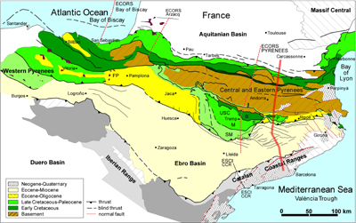
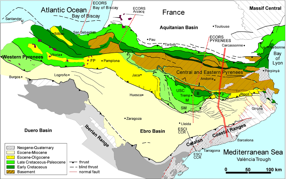
Map of the Pyrenees showing the location of deep crustal-scale reflection profiles across the Pyrenees and Catalan Coastal Ranges (red discontinuous lines are deep seismic reflection profiles). Red continuous line shows the location of both the crustal-scale cross-section in Fig. 8 and the balanced geological section in Fig. 10.
At the middle-late Eocene boundary (~37 Ma), the uplift of the Western Pyrenees triggered the end of the foreland basin stage and originated an intermontane basin limited by the Pyrenees, the Catalan Coastal Ranges and the Iberian Range (Burbank et al., 1992a; Vergés and Burbank, 1996). An internal fluvial network delivered sediments to the Ebro Basin characterised by a large central lake (e.g., Anadón et al., 1979; Arenas and Pardo, 1999).
Figure 7. Sediment flow diagram

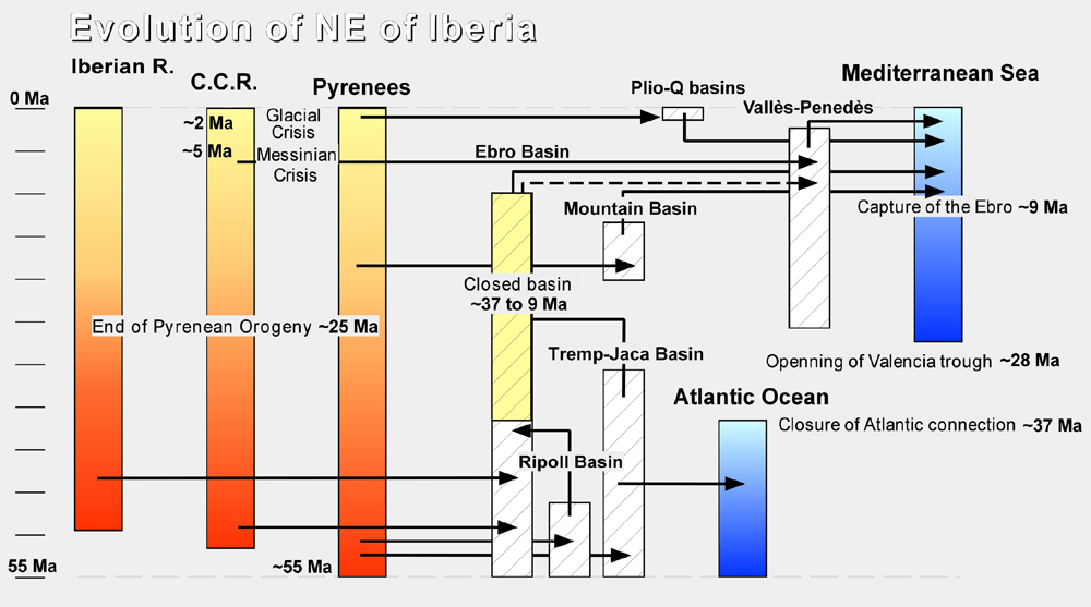
Sediment flow diagram for the Cenozoic evolution of NE Iberia between the mountain ranges (Pyrenees, Iberian Ranges (Iberian R.) and Catalan Coastal Ranges (C.C.R.), and the basins (see Fig. 6 for location). Active tectonics in mountains is depicted in reddish whereas the post-orogenic phase after about 25 Ma is depicted in yellowish. Ebro foreland basin and Ripoll and Tremp-Jaca piggyback basins were opened towards the Atlantic Ocean during initial stages of foreland development. Subsequently, the Ebro basin remained closed from ~37 Ma to ~9 Ma when it opened to the Mediterranean Sea. This opening occurred by the capture of the internal Ebro basin drainage by the Vallès-Penedès rift related rivers (García-Castellanos et al., 2001).
The end of deformation determined by magnetostratigraphy on growth strata attached to the front of the Pyrenean fold-and-thrust belt occurred during late Oligocene times (~24.7 Ma) (Meigs et al., 1996) although major basement uplift determined from fission track cooling ages ended at about 30 Ma (Fitzgerald et al., 1999).
During late Miocene times the endorheic Ebro fluvial system opened towards the Mediterranean Sea (e.g., Coney et al., 1996; García-Castellanos et al., 2001).
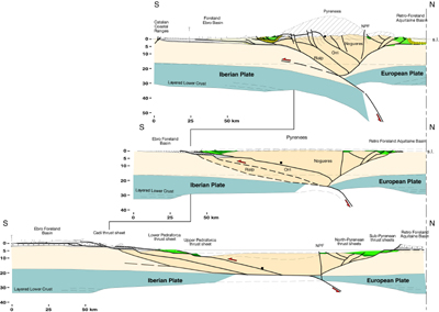
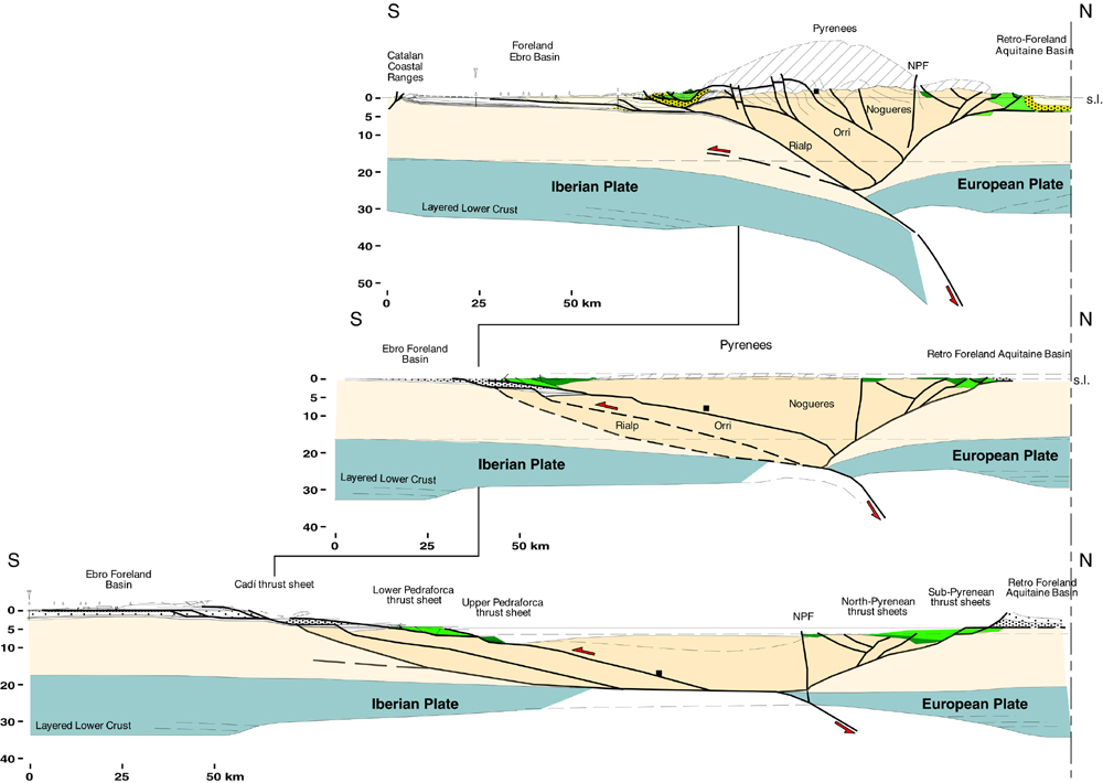
The Pyrenean orogen is an asymmetrical, double-wedge continental belt. The southern, and most significant, thrust system developed on top of the subducted Iberian Plate, whereas the northern thrust system developed on top of the European Plate (Fig. 8). From north to south the Pyrenean orogen comprises: 1) the Aquitaine retro-foreland basin, related to the northern Pyrenean wedge, 2) the North Pyrenean Thrust System, 3) the Axial Zone of the chain, formed by basement rock units, 4) the South Pyrenean Thrust System, and 5) the Ebro Foreland Basin associated with the southern Pyrenean wedge (e.g., Muñoz et al., 1986; Muñoz, 1992; Vergés et al., 1995).
Figure 8. Eastern Pyrenees
Eastern Pyrenees crustal-scale balanced and two restored sections during middle Lutetian and Early Cretaceous times (see discussion and techniques in text). See location of section in Fig. 6.
From E to W, the chain has been divided into Eastern Pyrenees from the Mediterranean Sea to the Segre Thrust (S in Fig. 6), the Central Pyrenees to the Pamplona Fault (FP in Fig. 6) and the Western Pyrenees. The irregular geometry of the Southern Thrust Sheets (mainly the upper ones) is inherited and corresponds to the boundaries of the Mesozoic extensional basins. The South Central Unit (USC in Fig. 6) has a trapezoidal shape bounded by the Segre thrust in its eastern termination and by a set of ~N-S trending folds and thrusts (such the Mediano and Boltaña anticlines) in its western termination (Séguret, 1972).
The western continuation of the Pyrenees has been less explored than the eastern and central segments. During the last decade, however, a large effort has been made to study the Alpine component of the mountain ranges aligned with the Pyrenees to the west of the Pamplona Fault (Fig. 1 and Fig. 6). To the west of the wide Basco-Cantabrian system of folds and thrusts (e.g., Cámara, 1997), the Cantabrian Mountains, mainly constituted by Paleozoic rocks, have been interpreted as uplifted above a 30¼ thrust ramp dipping towards the N during the Alpine compression overthrusting lower Miocene deposits of the Duero Basin (Alonso et al., 1996). To the N, the Alpine structure of the Western Pyrenees and Cantabrian Mountains is well imaged in the ESCI N-4 deep seismic profile (Alvarez-Marrón et al., 1995; Pulgar et al., 1996), (see location in Fig. 1). This profile shows a north-directed thrust system involving Tertiary deposits on top of transitional to oceanic crust of the Bay of Biscay.
Towards the western end of the Iberian Peninsula, small transpressional basins (alike As Pontes in Fig. 1) were infilled with alluvial to lacustrine deposits during late Oligocene and earliest Miocene (Cabrera et al., 1996; Huerta et al., 1997).
The Pyrenees consists of the North Pyrenean thrust system, basement Axial Zone (in ruled brown), and the South Pyrenean thrust system (in green for upper thrust sheets and yellow for lower thrust sheets), (Fig. 6). A balanced and two restored sections across the eastern Pyrenees show the complete structure of the Pyrenean orogen (Vergés et al., 1995), (Fig. 8). The upper crustal rocks have been balanced by the length of the strata. Basement units and the lower layered crust have been balanced by area. In the intermediate restored section during middle Lutetian it is assumed that erosion (ruled pattern) is equivalent to the early to middle Eocene clastic basin fill and that the Nogueres basement unit has been internally thickened during its emplacement. The final composite restored section shows the unfolding of all sedimentary basins and basement units. Four different stratigraphic levels have been taken as horizontal reference levels: the Cardona Formation, the top of the Beuda Formation, the top of the Paleocene section and the base of the Late Cretaceous section. Surface and subsurface geometry between the lower Cretaceous basins is speculative (see discussion in Vergés and García Senz, 2001). A lithospheric numerical modelling has been performed along the Central Pyrenees following the ECORS profile (Beaumont et al., 2000). These authors concluded that the formation of the Pyrenees was influenced by the reactivation of Mesozoic and Hercynian structures and that the Iberian lower crust and upper mantle were subducted below the mountain chain.
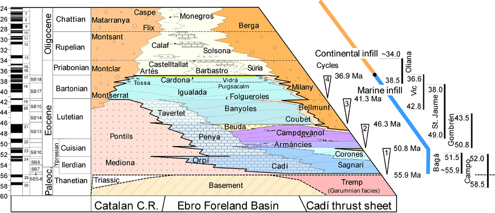
Figure 9. Stratigraphic panel across the Eastern Pyrenees and its related foreland basin
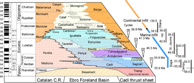
Biostratigraphic data combined with magnetostratigraphic information define the chronostratigraphic framework of the study area (Burbank et al., 1992a; Burbank et al., 1992b; Serra-Kiel et al., 1994; Vergés and Burbank, 1996; Serra-Kiel et al., 1998). Global polarity time scale from Cande and Kent (1995), and larger foraminifera shallow bentic zones (SBZ) from Serra-Kiel et al. (1998).
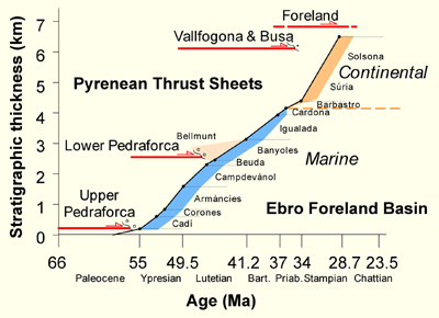
The southeastern Pyrenean fold-and-thrust belt shows very well preserved coupled tectonic and sedimentation (Fig. 9) permitting to determine rates of geological processes (Fig. 10). From S to N the section shows:
(a) the almost undeformed foreland basin with the SE-sourced Montserrat fan-delta (López-Blanco et al., 2001), (Fig. 10 A);
(b) the Oló, Súria and Cardona detached and thrusted anticlines above the Cardona salt décollement level (Ramírez and Riba, 1975; Vergés et al., 1992; Sans and Vergés, 1995; Sans et al., 1996), (Fig. 10 B);
(c) alluvial and fluvial Upper Eocene-Lower Oligocene sediments show a double syntectonic wedge geometry related to the growth of the Puig-reig anticline;
(d) the frontal Vallfogona thrust limits the allochthonous south Pyrenean units (Cadí and Pedraforca thrust sheets); a substantial number of upper Eocene-lower Oligocene growth strata are linked to the emergent front of the Pyrenees alike in Sant Llorenç de Morunys area (Riba, 1976; Ford et al., 1997; Suppe et al., 1997), (Fig. 10 C).
(e) the Lower Pedraforca thrust sheet is constituted by several tectonic units describing a break-back sequence of thrusting dated by different units of lower and middle Eocene growth strata (Martínez et al., 1988; Ramos et al., 2002), (Fig. 10 D).
(f) the Upper Pedraforca thrust sheet is constituted mainly by lower Cretaceous rocks forming a positive inversion along the southern margin of the lower Cretaceous extensional basin. Alluvial and fluvial Paleocene deposits overlap the basal thrust recording the latest emplacement of the thrust sheet (Vergés and Martinez, 1988; Vergés, 1999), (Fig. 10 E).
(g) the present gentle south dipping position of the Upper Pedraforca basal thrust is due to the general southern tilting of thrust sheets during the emplacement of lower and younger basement thrust sheets (Muñoz et al., 1986), (Fig. 10 F).
Figure 10. Balanced section across the southeastern Pyrenees
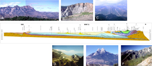
Balanced section across the southeastern Pyrenees with selected pictures from different tectonic units (from Vergés, 1999). Views of the southern margin of the Ebro Basin with the fan delta conglomerates of Montserrat (A), of the Cardona detachment anticline (B), of the Sant Llorenç de Morunys growth strata (C), of the front of lower Pedraforca thrust sheet front -N is to the left of the picture- (D), of the upper Pedraforca thrust sheet (E), and of the basement-cover contact dipping to the S (F). See location of section in Fig. 6.
Total shortening between points A and B is 69.2 km or 54% (Vergés, 1999), whereas the total shortening in this transect is about 125 km (Vergés et al., 1995).
Along the ECORS profile, the comparison of balanced and restored crustal sections results in 149 km of shortening (Muñoz, 1992) and 165 km according to modelling (Beaumont et al., 2000). Shortening decreases from the Central Pyrenees towards the W. A transect to the E of the Pamplona Fault accounts for 80 km of shortening (Teixell, 1998), whereas only 50 km is accounted for the Basco-Cantabrian fold-and-thrust belt. To the W, the Cantabrian Mountains display more than 26 km of shortening (Alonso et al., 1996).
Area balancing using balanced and restored sections along the ECORS profile determined that the amount of lower crust and upper mantle missing is of about 90 km, which could be due to subduction of the Iberian plate underneath Europe (Muñoz, 1992). This possibility was confirmed by the magnetotelluric survey along the same profile (Pous et al., 1995; Vacher and Souriau, 2001). These studies shows a steep north-dipping, high conductivity body, which reaches a depth of about 90 km and has been interpreted as subducted partly melted lower crust and lithospheric mantle.
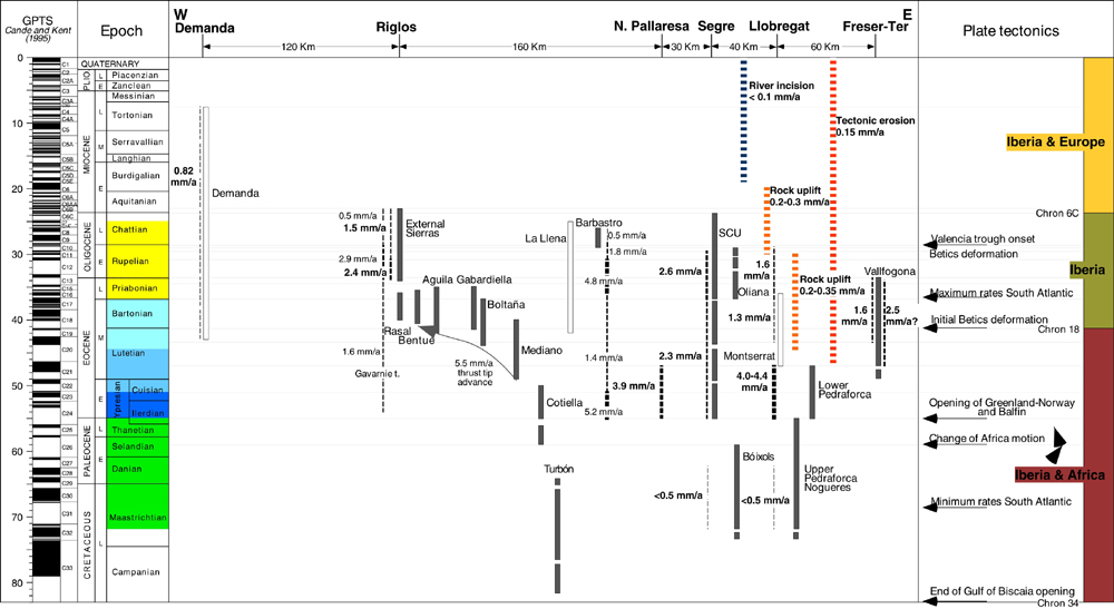
The Eastern Pyrenean sections permit to calculate the timing of thrust sheet emplacement and rates of shortening and thrust tip advance as depicted in Fig. 11 and Fig. 12. However, the good preservation of growth strata along the strike of the Pyrenean Range (Vergés et al., 2002) permits the calculation of rates of shortening in selected transects covering more than 410 km.
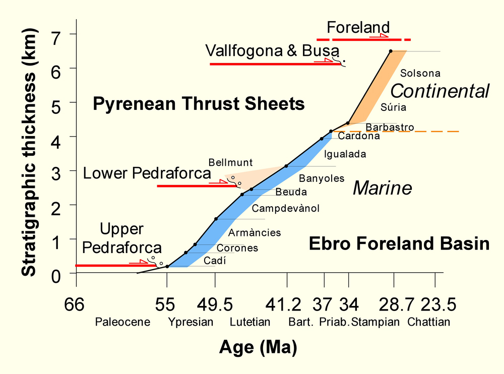
Figure 11. Syntectonic foreland sediments
Undecompacted stratigraphic thickness of syntectonic foreland sediments from Paleocene to Oligocene time and age of cover and basement thrusting along the Eastern Pyrenees cross-section depicted in Fig. 10 (from Vergés et al., 1995).
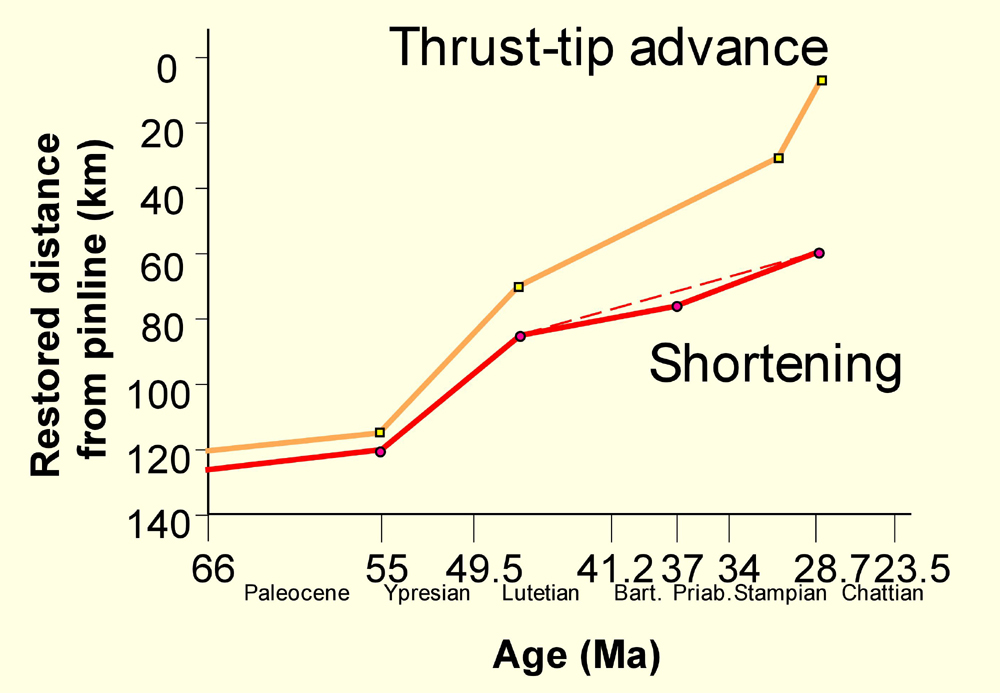
Figure 12. Rates of shortening
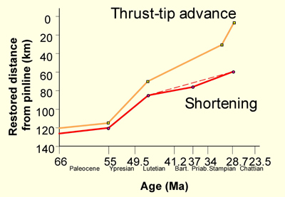
Rates of shortening along Eastern Pyrenees cross-section depicted in Fig. 10 (from Vergés et al., 1995). Rock uplift rates during Pyrenean shortening are based on cross-section reconstructions (Vergés et al., 1995). Tectonic erosion of 0.15 mm/yr is based on crustal-scale reconstructions across the Eastern Pyrenees (Vergés et al., 1995). This calculation, however, assumes a simple approach with a constant rate of uplift and erosion during both the collision and post-collision stages. Maximum rates of erosion took place during the Pyrenean orogen (Fitzgerald et al., 1999), and during the dissection of the Pyrenees and Ebro Basin after its opening towards the Mediterranean at ~9 Ma (see Fig. 7). River incision rate was also calculated to give a minimum amount. If we use the same numbers but starting at about 9 Ma we obtain almost 0.2 mm/yr.
The distribution of the rates of shortening for the southern part of the Pyrenees shows 3 different periods roughly related with the emplacement of different thrust sheets (Fig. 13), (based on Vergés, 1999).

The first period (older than 55 Ma) was characterised by very low shortening rates of less than 0.5 mm/a and related to the emplacement of the uppermost thrust sheets as a result of the positive tectonic inversion of pre-existing rifted Mesozoic basins (upper Pedraforca, Bóixols and Turbón thrust sheets). The second period (from 55 to 47 Ma), which corresponded to the highest rates of shortening between 4.0 and 4.4 mm/a, was correlated to the motion of the intermediate units (lower Pedraforca and South Central Unit thrust sheets). The front of these thrust sheets had a submarine emplacement during the consumption of previously thinned Iberian crust. A third period (from 47 Ma to the middle Oligocene), in which rates varied from 1.5 to 2.6 mm/yr. Deformation during this period affected the transition zone between thinned and undeformed crusts.
The combination of the southern Pyrenees shortening rates with a constant shortening rate of 1 mm/yr for the northern side of the orogen supports a convergence rate between the northeastern part of the Iberian plate (the present Ebro Foreland Basin) and Europe of almost 6 mm/yr during the most rapid period of continental plate collision during the early-middle Eocene (Vergés et al., 1995).
Rates to the west of the Noguera Pallaresa river are deduced from Meigs and Burbank (1997). The Mediano, Boltaña, Gabardiella, Pico del Aguila, Bentué and Rasal anticlines consitute a set of N-S oriented anticlines developed following an oblique-lateral propagation of deformation at the western termination of the South Central Unit. The rate of oblique-lateral propagation of deformation was 5.5 mm/yr (data from Millán et al., 1994; Poblet and Hardy, 1995; Poblet et al., 1997). Rates along the Riglos transect include results from Hogan and Burbank (1996) and Teixell (1996). The la Demanda thrust sheet shortening rates are from Muñoz-Jiménez and Casas-Sainz (1997). Other cross sections, which provide timing information, are constructed along the Noguera Ribagorçana river (Teixell and Muñoz, 2000) and to the east of the Pamplona Fault (Teixell, 1998).
Although the shortening data related to the Catalan Coastal Ranges are less reliable growth strata close to its front provide a good indication of deformation time. The Montserrat fan-delta conglomeratic section (López-Blanco et al., 2001) and the La Llena alluvial-fluvial system (Colombo and Vergés, 1993) indicate the timing of thrusting in the southeastern margin of the foreland Ebro basin.
The end of thrusting was diachronous, migrating from east to west (this interpretation could be modified by the lack of younger deposits in the eastern Ebro Basin due to the important exhumation processes, which occurred after the cessation of thrusting during Oligocene times. Between the Freser-Ter and and Segre transects the migration rate for the end of thrusting was 11 mm/yr. and from this transect to the west was 20 mm/yr.
Major plate tectonic events related to the Iberian Plate during the Tertiary are shown in Fig. 13. Although their close relationship with Pyrenean events may be conjectural, there is a remarkable coincidence between high rates of thrusting in the Pyrenees and both the abrupt change of the Africa convergence vector (Srivastava and Tapscott, 1986) and the initiation of the opening of Greenland, Baffin and Norway Seas at early Eocene times (Ziegler, 1992). The end of this period of rapid deformation coincides with the initiation of deformation on the Betics, documented by field data (e.g., Lonergan and Mange-Rajetzky, 1994). The end of Pyrenean thrusting roughly corresponds with important deformation in the Betics (Banks and Warburton, 1991) and with extension of the westernmost Mediterranean Sea related with the formation of the Gulf of Lions and the València Trough (e.g., Roca, 2002).