The Iberian Peninsula constitutes the westernmost segment of the 12,000-km long Alpine-Himalayan Belt originated by the Tertiary closure of the Tethys during the collision of India, Arabia and Africa against Asia and Europe (e.g., Dercourt et al., 1986). The Iberian Peninsula, constituted a separated microplate between Africa and Europe. The continuous motion of Africa towards the north and northwest concluded with the Pyrenean continental collision between Iberia and Europe before the opening of the western Mediterranean basins in Oligocene times (Fig. 1). Deformation propagated intraplate producing the inversion of previous Mesozoic rifted basins with different orientations: NE-SW trend for the Catalan Coastal Ranges, and NW-SE trend for the Iberian Range. The Betic Cordillera, showing an ENE-WSW direction, also corresponds to the inversion of the southern Iberian Margin together with oceanic fragments related to the former Africa-Iberia oceanic transform boundary.
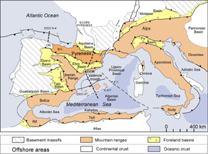
Figure 1. Map of western Europe
Map of western Europe with location of principal orogenic chains related to the Africa-Europe collision (from Vergés and Sàbat, 1999). The Pyrenean Range corresponds to the westernmost limit of the about 12,000-km long Alpine-Himalayan Belt. The ECORS Pyrenees, the ESCI Valencia Trough and the ESCI N-4 Iberian Margin are shown. CCR: Catalan Coastal Ranges; B-C: Basco-Cantabrian thrust belt; CM: Cantabrian Mountains; and AP: As Pontes.
The Pyrenean orogen constitutes a well-know orogenic system because its relative small size and well-constrained syntectonic deposits. In its foreland basins, particularly in the Ebro Basin where it is possible to determine the timing of shortening of individual structures as well as the sequences of deformation both perpendicular and parallel to the strike of the chain. However, total inversion of Mesozoic basins permits the observation of both extensional and compressional geometries, which are important for oil industry. Finally, a large amount of geophysical data mostly assembled along the ECORS profile in the Central Pyrenees together with a youth topography and river drainage development permit to investigate the recent rise of the Pyrenean Mountains, as we know them today.
We present in this paper a summary of major geodynamic events that took place between Iberia and Europe since the middle Mesozoic starting with the Mesozoic rifting and formation of the Gulf of Biscay in the Western Pyrenees. The syn-collisional evolution of the Pyrenees shows the geometry and timing of the Pyrenean fold-and-thrust belt. The paper terminates with the present-day crustal and lithospheric structures of the Pyrenees, which provide the final stage representative of the sum of the entire evolution.