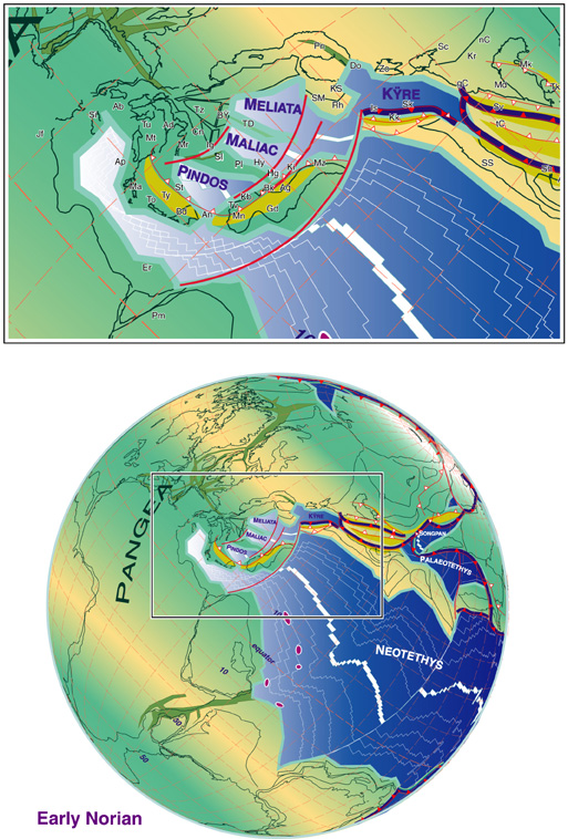
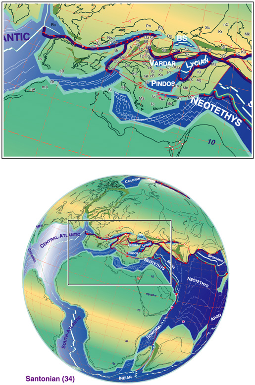
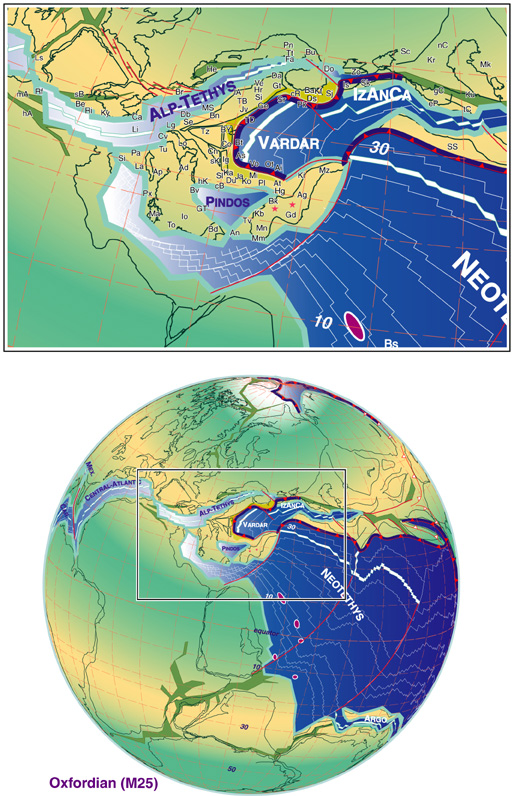
The reconstructions shown in figure 4 to 9 are based on a tight pre break-up Permian fit (fig 3) as well as magnetic anomalies from the Central Atlantic. They have been constructed in a continuous effort to apply plate tectonic concept to palinspatic model of the western Tethys, moving away from pure continental drift model not constrained by plate limits (Stampfli and Borel, 2002). The constraints and data bases used in that project can be found in the literature cited above in the introduction. This plate model takes into account the likelihood of a Late Paleozoic rifting and sea-floor spreading of the eastern Mediterranean basin (Stampfli et al., 2001c). This opening would be concomitant with the opening of the NeoTethys and the northward drifting of the Cimmerian continents since late Early Permian. This model considers also a late closure of the PaleoTethys (Middle to Late Triassic) on a Greek and Turkish transect of the Tethyan realm (Stampfli et al., 2002a), accompanied by the opening of back-arc basins (fig. 4, Meliata, Maliac and Pindos back-arc basins).
Figure 3. Plate 3
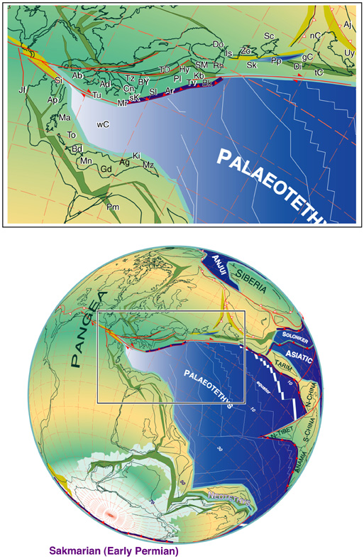
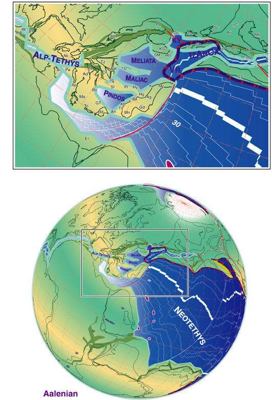
Notes for figures 3 to 9. Early Permian to Late Cretaceous reconstructions of the western Tethyan realm, (modified from Stampfli et al., 2001a; Stampfli and Borel, 2002), rift zone are shown in greenish color, foreland in orange color. Legend: AA, Austro-Alpin; Ab, Alboran; Ad, Adria s.str.; Ae, Abadeh; Ag, Aladag; Ah, Agh-Darband; Ai, Argolis ophiolites; Aj, Ajat; Al, Alborz; An, Antalya; Ap, Apulia s.str.; AP, Aspromonte, Peloritani; Ar, Arna accretionary complex; As, Apuseni-south, ophiolites; At, Attika; AT, Alpine Tethys; Av, Arvi ; Ba, Balkanides, externat ; Bc, Biscay, Gascogne; Bd, Beydaghlari; Be, Betic; Bh, Bihar; Bi, Ba'id; Bk, Bolkardag; Bn, Bernina; Br, Briançonnais; Bs, Bisitoun seamount; Bt, Bator-Szarvasko ophiolites; Bu, Bucovinian; Bü, Bükk; Bv, Budva; By, Beyshehir; Bz, Beykoz basin; Ca, Calabride; cA, central Afganistan; cB, central Bosnia; Cc, Caucasus s.l.; cI, central Iberia; Ci, Ciotat flysch; Co, Codru; Cn, Carnic-Julian; CP, Calabria-Peloritani; cR, circum-Rhodope; Cv, Canavese; Da, Dacides; Db, Dent Blanche; DD, Dniepr-Donetz rift; Dg, Denizgören ophiolite (IP suture); DH, Dinarides-Hellenides; Do, Dobrogea; Dr, Drina-Ivanjica; Ds, Drimos ophiolites; Du, Durmitor; Dz, Dzirula; eP, east Pontides; Er, Eratosthen; Fa, Fatric; Fr, Farah basin; gC, great Caucasus; Gd, Geydag; Ge, Gemeric; GS, Gory-Sovie; GT, Gavrovo-Tripolitza; Gt, Getic; Gü, Gümüshane; hA, high-Atlas; Ha, Hadim; He, Helvetic rim basin; Hg, Huglu; hK, high karst; Hr, Hronicum; Hy, Hydra; IA, Izmir-Ankara ocean; Ig, Igal trough; Io, Ionian; iP, intra-Pontides; Is, Istanbul; Ja, Jadar ; Jf, Jeffara rift; Jo, Jolfa; Jv, Juvavic; Ka, Kalnic; Kb, Karaburun; Kd, Kopet-Dagh ; Kf, Kotel flysch; Ki, Kirshehir; Kk, Karakaya forearc; Ko, Korab; KS, Kotel-Stranja rift; KT, Karakum-Turan; Ku, Kura; Kü, Küre ocean; Ky, Kabylies; La, Lagonegro; Lg, Longobucco; lA, lower Austroalpine; Lg, Ligerian ; Li, Ligurian; Lo, Lombardian; Ls, Lusitanian; Lu, Lut ; Ly, Lycian ophiolitic complex; mA, middle Atlas; Ma, Mani; Mc, Maliac rift/ocean; Md, Mozdak; MD, Moldanubian; Me, Meliata rift/ocean; Mf, Misfah seamount; Mi, Mirdita autochton; Mk, Mangyshlak rift; Mm, Mamonia accretionary complex; MM, Meguma-Meseta ; Mn, Menderes; Mo, Moesia; Mr, Mrzlevodice fore-arc; Ms, Meseta; MS, Margna-Sella; Mt, Monte Amiata fore-arc; Mz, Munzur dag; nC, north Caspian; NCA, North Calcareous Alps; Ni, Nilüfer seamount; Nr, Neyriz seamount; Ns, Niesen flysch; Ot, Othrys-Evia ophiolites; Pa, Panormides; Pd, Pindos rift/ocean; Pe, Penninic; Pi, Piemontais; Pk, Paikon intra oceanic arc; Pl, Pelagonian ; Pm, Palmyra rift; Pn, Pienniny rift; Px, Paxi; Py, Pyrenean rift; Qa, Qamar; Qi, Qilian; Qn, Qinling north; Qs, Qinling south; Rf, Rif, external; Rh, Rhodope; Ri, Rif, internal; Ru, Rustaq seamount; Rw, Ruwaydah seamount; sA, south Alpine; sB, sub-Betic rim basin; Sc, Scythian platform; sC, south Caspian basin; Sd, Srednogorie rift-arc; Se, Sesia (western Austroalpine); Sh, Shemshak basin; Si, Sicanian; Sj, Strandja; Sk, Sakarya; sK, south-Karawanken fore arc; Sl, Slavonia; Sm, Silicicum; SM, Serbo-Macedonian; Sr, Severin ophiolites; SS, Sanandaj-Sirjan ; sT, south-Tibet; St, Sitia; Su, Sumeini; Sv, Svanetia rift; Ta, Taurus, s.l.; Tb, Tabas; TB, Tirolic-Bavaric; tC, Transcaucasus; TD, Trans-Danubian; To, Talea Ori; Tr, Turan; Tt, Tatric; Tu, Tuscan ; Tv, Tavas+Tavas seamount; Ty Tyros fore arc; Tz, Tizia; uJ, upper Juvavic; Va, Valais trough; Ve, Veporic; Vo, Vourinos (Pindos) ophiolites; Vr, Vardar ocean; wC, western-Crete (Phyl-Qrtz) accr. cpl; WC, West-Carpathian; Ya, Yazd.
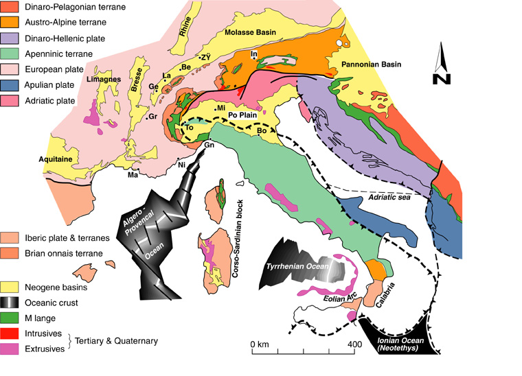
The Apulia Adria problem
A review of palaeomagnetic data regarding the Alpine and Mediterranean area suggests that the method cannot sort out paleopositions of small terrains having suffered small amounts of displacement. It is possible, however, to show that the Apulian plate s.l.(Italy) suffered relatively little rotation in regard to Africa since Triassic (e.g. Channell, 1992; 1996). This leaves open the question of an Apulian plate being an African promontory or not. Also, the continuity between the active subduction zone under Greece and the outer Dinarides (de Jonge et al., 1994; Wortel and Spakman, 1992) shows that there is a possible plate limit between Apulia s.l. and the autochthonous of Greece.
Together with major problems concerning the reassembling of micro-plates in a pre-break-up position (fig. 3 & 4), this leads us to consider that the Apulian plate s.l. is most likely cut into two pieces, an Apulian plate s.str. to the south and an Adriatic plate s.str. to the north. The Apulian part is definitely an African promontory from Middle Triassic to recent times and represents the eastern most Cimmerian element detached from Gondwana in Late Permian times during the opening of the East Mediterranean – Neotethys, basin. The Adriatic and Apulian plates were welded in an eo-Cimmerian collision phase during the Triassic and were part of the African plate until Early Cretaceous. Then, Adria started a left-lateral displacement to reach its final position in the Miocene as a separate entity, it was partially subducted under the Dinarides and the Apennines.
The Adriatic plate can therefore be considered as a displaced terrain like most large tectonic units from the former southern margin of the Alpine Tethys – the Austroalpine, Carpathians and Tisia composite terrains. Unlike Adria and Tisia which are still rooted in the lithosphere, the Austroalpine and Carpathian composite terrains were decoupled at upper crustal level and incorporated in the orogenic wedge. Their composite nature comes from the fact that they record the closure not only of the Alpine Tethys but also of older oceanic domains such as the Meliata-Maliac and Vardar oceans.

Triassic back-arc oceans of the PaleoTethys
The exotic character of the upper Austroalpine terrain (North Calcareous Alps) and the necessity to open an oceanic area between the internal part of the Carpathian domain (Tisia) and the Austroalpine domain is now widely accepted. This Meliata-Hallstatt ocean is now better known and its different parts have been studied and dated in some details (Kozur, 1991; Haas et al., 1995). We consider the opening of this Meliaticum domain as a result of continuing subduction along the eastern part of the European margin in the Late Paleozoic (Stampfli et al., 2001b; Vavassis et al., 2000). The northward subduction of a remnant PaleoTethys induced the opening of back-arc type basins already in Carboniferous-Permian times in a general context of cordillera collapse following the accretion of the Variscan terrains in Early Carboniferous time (Ziegler and Stampfli, 2001). The back-arc spreading lasted until Late Triassic in the Mediterranean domain (Kozur, 1991; Stampfli et al., 2001b).

The Meliata rift possibly extended westward to the Ivrea zone (Zingg et al.,1990) in the Southern Alps where Permian and Triassic rifting and volcanism is well documented (e.g. Winterer and Bosellini, 1981). The Meliata rift extension in that region would have been of intracontinental type and is also possibly recorded in the Sesia nappe (Venturini, 1995). However, remnant of Meliata oceanic material and metamorphic rocks related to its closure are not present in the Western Alps. Accelarating slab roll-back, and even detachment of the PaleoTethys slab, induced a jump of the back-arc spreading, to the Maliac rift in late Middle Triassic (De Bono, 1998) then a new jump opened the Pindos in Late Triassic (Vavassis, 2001; Stampfli et al., 2002a).
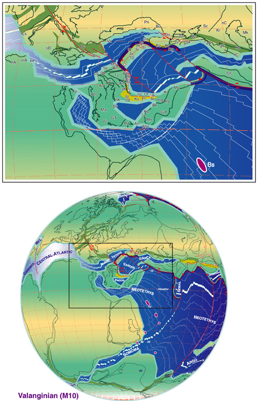
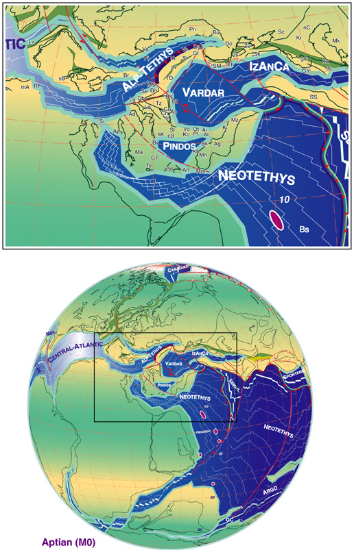
During the opening of the Central-Atlantic/Alpine Tethys system the Meliata oceanic domain started subducting southward in connection with the southward subduction of the Küre basin north of Turkey (Stampfli et al., 2001b). The slab roll-back of Meliata was responsible for the opening of the Vardar back-arc basin in Middle Jurassic times, which partially obducted in Late Jurassic onto the Pelagonian micro-continent (in Greece, Bulgaria, Yougoslavia, fig. 6; e.g. Baumgartner, 1985; De Bono, 1998).
The opening and closing of the Meliata-Maliac domain affected the whole Alpine history. First it created a generalised thermal subsidence starting in the Late Permian responsible for the large scale Triassic transgression on the Alpine regions. Then, its closure in the Late Jurassic (Kozur, 1991) affected the whole Austroalpine domain (the Austrian deformation phase) and can be seen as a major element in the onset of the closure of the Alpine Tethys itself on an Eastern Alps transect (Froitzheim et al., 1996). The southward subduction of the Meliata-Küre system is certainly responsible for the (local) southward subduction of the European slab, a unique feature in the whole Alpine s.l. system where generally the southern continents are subducted northward (Africa, Arabia, India).
The Alpine Tethys rifting
Late Triassic ages obtained from shear zones in the Southern Alps (Hunziker et al., 1992; Schmid et al., 1987) witness important transtensive events which eventually developed into the opening of the central Atlantic/Alpine Tethys ocean and the final break-up of Pangea. The areas affected by transtension and emplacement of mafic material during the Permo-Triassic became subsiding rim-basins of the Jurassic Alpine Tethys (fig. 4). This is the case for the Médianes (Subbriançonnais) and Helvetic rim basins. Paleozoic faults were also reactivated on a large scale in these domains to form shallow half-grabens (Borel, 1997). The Jurassic rifting is actually cutting in between these zones of thinned and already cold lithosphere, most likely using older structures. It has to be emphasised here that the thermal subsidence of large parts of the Alpine orogen started in Triassic time and that this subsidence is hardly disturbed in areas far enough from the Jurassic rift (Stampfli, 2000). These different subsidence behaviours can be used to sort out paleogeographic units; they also indicate the importance of the Permo-Triassic lithospheric extensional phase.
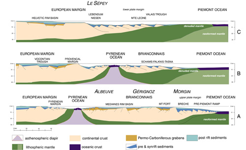
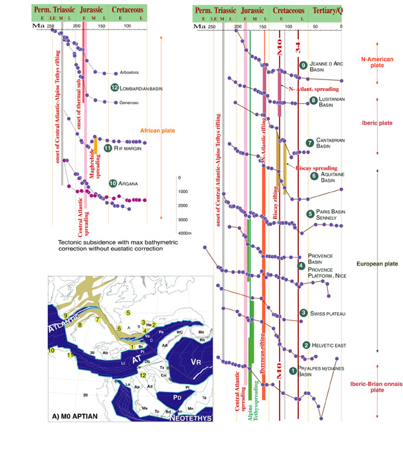
Subsidence patterns of the marginal areas of the Alpine Tethys (Borel, 1995; Loup, 1992) together with stratigraphic and sedimentological records allow to place the onset of rifting in the Sinemurian (fig. 10). Spreading in the central Atlantic is placed in the Early Toarcian (Steiner et al., 1998). The former Atlantic rift would have extended first toward the Lombardian basin, which aborted, then, the rifting jumped to the Alpine Tethys s.str. (the Liguro-Piemont Penninic ocean) where the onset of spreading is of probable Aalenian to Bajocian age. Gabbros have been dated in several areas of the Alpine Tethys, the oldest dating are usually Bajocian (e.g. Bill et al., 1997), in Corsica older ages have been found and points to a possible late Toarcian-Aalenian age (Beccaluva et al 1981). It should be emphasized here that up to 100 to 150 km of the nascent ocean were made of denuded continental mantle, based on comparison with the Galicia margin (e.g. Manatschal and Bernoulli, 1998; Müntener and Hermann, 2001), and, in view of the slow spreading of the ocean (Rampone and Piccardo, 2000), clear sea-floor spreading was delayed in regard of the onset of thermal subsidence which is older than Bajocian, the Bajocian sequences being generally transgressive on the rift shoulders.
Figure 10. Synthetic subsidence curves

Synthetic subsidence curves for selected circum-Iberia and Atlantic domains (modified from Borel, 1997 and Stampfli and Borel, 2000) and location map. The subsidence program used to derived the curves is from R. Schegg., Time scale fromOdin (1994).
Rim Basins
Thermal subsidence of the Alpine Tethys margins in the Bajocian affected large areas around the new oceanic area. The progradation of carbonate platforms toward the rift/ocean was hampered by the presence of rim basins on both sides of the Alpine Tethys in the western Alps. To the north the Helvetic-Dauphinois basin and its SW extension toward the Sub-Briançonnais rim basin, Sardinia and the Sub-Betic rim basin. To the south the Lombardian rim basin representing a clear aborted arm of the Alpine Tethys (Bertotti et al., 1993), active from Late Triassic to Early Jurassic. Progradation did not succeed infilling these rim-basins and the former rift shoulders of the Alpine Tethys (the Briançonnais and south Helvetic domains in the north and the Canavese and lower Austro-Alpine domains to the south) became drowned submarine ridges developing condensed pelagic sequences. Therefore a general phase of sediment starvation characterises the distal part of the Alpine Tethys margins and the ocean itself. However, small carbonate platforms developed for a short time (Bajocian-Oxfordian) around the rift shoulders, e.g. the Briançonnais platform (Septfontaine, 1983) and in some south Helvetic units (Lempicka-Münch, 1996). They were linked to larger platforms along the rift shoulder as found in Corsica and Sardinia, and were finally drowned in the Late Jurassic; the south Helvetic platform could never develop as a large entity and must have been made of small carbonate patches already drowned in Oxfordian times. The progradation of the Briançonnais platform took place towards the rim basin – to the north, away from the rift shoulder, so in an opposite direction of the general progradation on the European margin.
The "Valais ocean" question, and the Alps Pyrenees connection
From much, sometimes contradicting data concerning the Iberian drift (Stampfli, 1993; Stampfli et al., 1998) it can be determined that the opening of the Pyrenean rift system started in Late Jurassic times when Iberia was detached from New-Foundland. The minimal opening would be 200 km following the data from Malod and Mauffret (1990) or 350 km using the data of Sibuet and Colette (1991). Discrepancies stem from the former situation of Iberia with regard to New Foundland. The data of Srivastava et al. (1990) and of Srivastava and Verhoef (1992) allow to narrow down these differences and their proposal was applied for our model where a tight Permian fit for Pangea is used.
The portion of the Pyrenean rift between Provence and the Briançonnais was roughly parallel to the central Atlantic rift between Iberia and New Foundland (fig. 6 & 7) and, therefore, certainly opened at the same time. The oldest magnetic anomaly in that part of the Atlantic is M0 (Hauterivian to earliest Aptian depending on the time scale…); however the sea-floor spreading is inevitably slightly older than the first clear magnetic anomaly.
In the Pyrenean region, the thermal event linked to the rising asthenosphere has been placed between 115 Ma and 80 Ma by Montigny (1986), it is regarded as Late Albian (Å 100 Ma) by Peybernes (in: Debrand-Passard and Courbouleix, 1984). The Bay of Biscay opened later, together with the Aquitaine basin and the reactivation of the Iberian rift (Vergés and Garcia-Senz, 2001), during the rotation of Iberia, after the Valanginian (Moreau et al., 1992) and after the Atlantic opening between Iberia and America, therefore, in Late Aptian-Albian times; spreading there stopped in the Campanian (A33 anomaly, see figure 9). Thermal subsidence is active in the Late Cretaceous for the Pyrenees and the Gulf of Biscay region (fig. 10) where the Cenomanian is largely transgressive on the former rift shoulders (Peybernès, 1976; Peybernès and Souquet, 1984; Simo, 1986).
The major change of sedimentation in the Briançonnais domain, located on the Iberian plate, is found at the top of the Calcaires Plaquetés (Python-Dupasquier, 1990) and can be dated as Barremian. It corresponds to a general drowning and starvation phase of the area at that time. There is also a major sedimentary gap in the Albian that we relate to the thermal uplift of the Briançonnais. The Helvetic-Dauphinois margin is also affected by the Pyrenean rifting phase, clearly expressed on the subsidence curves for the Helvetic and Swiss plateau domain (fig. 10).
Obviously the timing of sea-floor spreading along this new lithospheric fracture is not synchronous, even more because the northern border of the Iberic plate in the Pyrenean portion is of transform type and, may be, never generated sea-floor spreading, the crustal attenuation however reached denudation of continental mantle (the Lherzolites of Lherz).
The "Valais trough", as recognised in the western Alps in the present days, is actually the remnant of trapped Piemont sea-floor and of the toe of the Helvetic margin (fig. 6 to 9). The "Valais ocean" (as defined in Stampfli, 1993) was located south of France and we refer to it here as the "Pyrenean ocean" to avoid the confusion between Valais ocean and Valais trough. No direct traces of this ocean have been found so far because its suture was located exactly where the Algero-Provençal ocean re-opened in Oligo-Miocene times (Roca, 2001). The southern margin of the Pyrenean ocean was the Briançonnais peninsula (fig. 11), its northern margin was the Corbières-Provençal domain from the Pyrenees to the Maures-Estérel massifs. The Pyrenean margin of the Briançonnais outcrops in the Galibier region of the French Alps (Toury, 1985), well known for its Late Jurassic Brèche du Télégraphe (Kilian, 1891). Recent investigation there (Luzieux and Ferrari, 2002), showed us the development of a pull-apart type basins rapidly deepening under the CCD in Late Jurassic times and located to the north of the classic Briançonnais domain. This area developed facies different from the Swiss sub-Briançonnais during the Cretaceous, and is regarded as the most external sub-Briançonnais elements known so far. Its conjugate northern Provençal margin area is characterised by important erosion during the Oxfordian and the development of Albian basins deepening southward towards the "ocean", followed by inversion related basins accumulating thousands of meters of upper Cretaceous clastic deposits in a northward migrating fore-deep type basin (Debrand-Passard and Courbouleix, 1984). This shows a southward closure of the Pyrenean ocean on a Provençal transect, whereas a northward subduction took place on a Pyrenean transect (Vergés and Garcia-Senz, 2001), also recorded in Sardinia (Barca and Costamagna, 1997; Barca and Costamagna, 2000), but again a southward subduction took place westward in the Biscay ocean.
Figure 11. Early Cretaceous cross-sections of the European margin and position of the Pyrenean ocean
This Pyrenean orogen can be followed from the present Pyrenees eastward up to southern France (Provence), and continues in the Alps in the form of a large scale uplift of the Helvetic margin and local inversion of the Jurassic tilted blocks, well expressed by the deposits of the Niesen flysch (mainly Maastrichtian) and Meilleret flysch (Middle Eocene), sedimented on a structured Mesozoic basement. These flyschs clearly predate the Alpine collisional event in the Helvetic domain, characterised by the deposition of collisional flysch not before the earliest Oligocene.
Along the European margin it is interesting to note the similitude of facies between the Rheno-Danubian flysch and the Valais trough sequence (the Valais trilogy) from Albian to Late Cretaceous ((Stampfli, 1993 and references therein). The continuity of deep water clastic facies in these two domains allows to assign them to the same position with regard to the European margin (often referred as North Penninic basin; fig. 12). The presence of contourites and strong and changing current directions along the basin (Hesse, 1974) suggests a connection with major oceanic domains. In the Ligurian domain (south of the Briançonnais) such turbiditic deposits are absent, the Albo-Cenomanian formation being dominated by anoxic black-shale deposits. So the Valais trough, together with the Pyrenean ocean and the Bay of Biscay ocean, must be regarded as the connection between the Eastern Alpine Tethyan realm and the opening north Atlantic ocean during the Cretaceous and Paleogene.
Figure 12. Middle Eocene and Late Oligocene
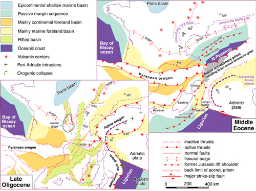
Middle Eocene and Late Oligocene maps of the Alpine Pyrenean area (modified from Stampfli et al., 1998).
Exotic terrains and margin duplication
In the northern margin: As discussed above, the separation of the Iberic plate from North-America in the Late Jurassic (the onset of spreading is dated as M0, Early Aptian - 121Ma; fig. 8) implies a separation of the Iberic plate from Europe too. This separation is brought about by the Pyrenean pull-apart rift system. The Briançonnais domain was attached to Corsica/Sardinia and therefore to the Iberic plate (Stampfli, 1993). Thus, its former position was more to the SE than usually supposed, a proposal already made by Frisch (1979). The most internal south-Helvetic (Ultrahelvetic) domains, the lower Penninic Simplo-Ticinese nappes and Valais zone (ie.Sion-Courmayeur zone, Sub-Médiane zone and the Bündnerschiefer area of central Switzerland) are therefore considered as former elements of the northern Piemont oceanic margin trapped by the eastward displacement of the Briançonnais terrain in front of them in Late Cretaceous times. This remnant trapped Jurassic oceanic strip with an Early Jurassic margin to the north and an Early Cretaceous margin to the south is called here the Valais trough, but was also sometimes referred as the north Penninic ocean or basin. This displacement induced a duplication of the Piemont northern margin in the present day Alpine orogen from the French Alps up to the Engadine window, but is not considered here to have any extension further eastward. The eastward escape of the Briançonnais was induced by the combined opening of the Atlantic and Bay of Biscay oceans and the large scale rotation of the Iberic plate together with Africa, as deduced from the magnetic anomalies from the Atlantic. This implies also a partial closure of the Valais trough already during the Late Cretaceous. The combined Africa-Iberia rotation was closely followed by a general shortening between Africa-Iberia and Europe, culminating into the Pyrenean orogen. But it was only during the Alpine collision that the Briançonnais domain became an exotic terrain, obducted in the Alpine accretionary prism (fig.12).
The Alboran plate (Rif, internal Betic, Kabylies, Peloritan, Corso-Sardinia and Calabria microplates, (Wildi, 1983) formed the southern margin of the Iberic plate (fig. 3 to 9). This margin was affected by deformation processes as from Early Cretaceous (Puga et al., 1995); resedimentation of the Dorsale Calcaire (former rift shoulder) in the flysch basin starts in Cenomanian time, grading into major olistostromic deposits in Maastrichtian (Gübeli, 1982; Thurow, 1987). However, these deformation are most likely related to local inversion and strike slip displacement between Africa and Iberia rather than to subduction because no shortening can be demonstrated at that time between the two plates. Subduction under the Iberic plate started only in Eocene/Oligocene times as a result of the Pyrenean orogeny and graded into major terrain displacements during the late Tertiary opening of the Algero-Provençal ocean, liberating the Alboran blocks from their Iberic motherland (fig. 12). These displacements generated duplication of paleogeographic elements, creating pseudo oceanic sutures. We propose a displacement toward the SW of the Internal Betic domains (together with the Rif) subsequently incorporated into the Betic orogen as a terrain.
The Iberic margin is considered a Tertiary active margin developing back-arc spreading, and the African margin as a passive margin. Terrain displacement was related to the slab roll-back of the remnant Alpine Tethys Ligurian basin, (fig. 12) and the lateral detachment of its slab. The Apenninic accretionary prism developed on the eastern side of Iberia and by Late Miocene time the slab roll-back had reached the Ionian basin (the western most part of the NeoTethys ) and this led to the opening of the Tyrrhenian oceans as a new generation of back-arc, accompanied by the drifting of the Calabrian micro-plate to its present position (fig. 13).

In the southern margin: The Early Cretaceous rotation of Iberia-Africa, as well as the closing of the remnant Meliata domain induced the closure of the Liguro-Piemont part of the Alpine Tethys ocean. This closure is quite different on the Austrian transect and the Swiss transect due to the presence/absence of the Meliata-Vardar domain. In the eastern Alps transect the subduction of the Alpine Tethys is the consequence of the subduction of the Meliata domain since Jurassic time, the subduction there can be seen as a continuous process during which the Austro-Alpine blocks were subducted and part of their covers was included in the accretionary prism to form the Middle and Upper Austro-Alpine nappe system (Faupl and Wagreich, 1999 and references therin). In the western Alps the Adria margin stayed passive for a longer time due to the fact that Iberia and Africa have the same wander path during the Cretaceous (at least between anomaly M0- Aptian and 34 - Santonian – fig. 7 to 9).
The subduction of the Piemont part of the Alpine Tethys is marked by HP/LT metamorphism of elements pertaining to the toe of the Austroalpine margin (Sesia massifs, Former back-stop of the prism) and to the accretionary prism s.str. (Tsaté nappe). Most of the eo-Alpine ages (Hunziker et al., 1992) seems now to be younger than formerly dated (e.g. Froitzheim et al., 1996), however some ages are still older than the onset of collision between the accretionary prism and the Briançonnais micro-continent and can for sure be related to subduction of the oceanic domain. Younger ages (Midle Eocene or younger) are related to the collision proper (Gebauer, 1999). Therefore the onset of oceanic subduction on a western Alps transect could be younger than proposed so far, but not younger than the incorporation of exotic elements in the accretionary prism represented by the Gets and Simme flysch. These exotic elements are made of ophiolitic blocks and blocks derived from the Lower Austro-Alpine margin, their minimum age is Cenomanian (Clément, 1986) and the onset of subduction of the Alpine Tethys can certainly be placed around that time (90-100 Ma). This time corresponds also to the onset of flysch deposition in the Lombardian rim basin (Bichsel and Häring, 1981). Before to become an active margin this western portion of the lower Austoalpine margin suffered a westward displacement in regards to Adria (Frank, 1987; Froitzheim et al., 1994; Trümpy, 1992) related to the closure of the Vardar/Hallstatt-Meliata oceanic realms and the important rotation of Africa at that time to which Adria was still attached. This induced trapping of Piemont oceanic crust or mantle between the Southern Alps domain (Adria) and the Lower Austroalpine units as found between the Canavese zone and the Sesia nappe (Venturini, 1995).
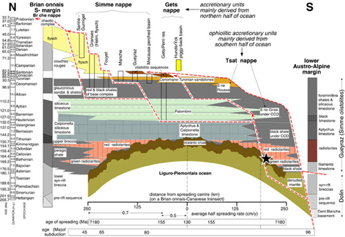
Figure 14. Stratigraphy and origin of the oceanic series and accretionary sequences
Stratigraphy and origin of the oceanic series and accretionary sequences found in the western Swiss Alps (modified from Stampfli et al., 1998).
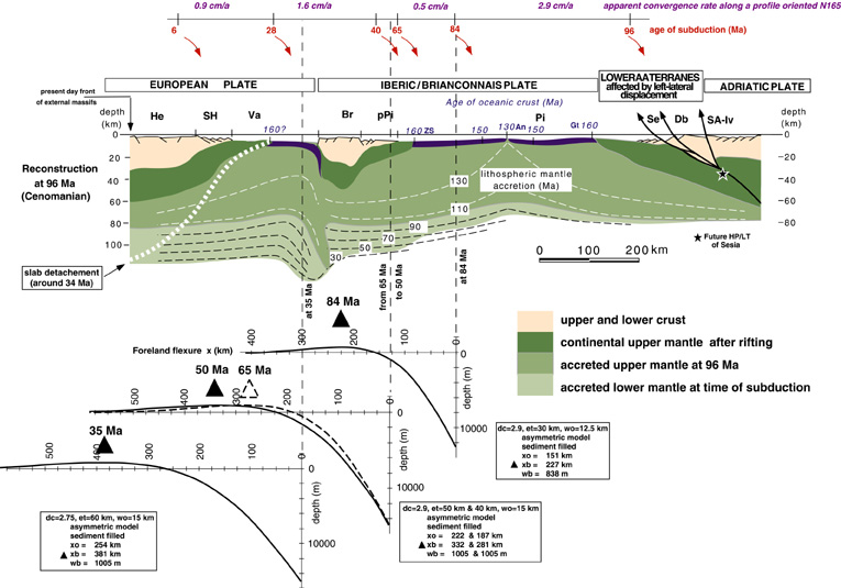
Subduction and obduction processes affecting the oceanic sequences of the Piemont ocean are shown on figures 14 and 15. Spreading rates were obtained from the central Atlantic magnetic anomalies which allow to define the opening of the Alpine Tethys at least until Early Cretaceous. The rates of convergence between Africa and Europe are also derived from the Atlantic magnetic anomalies and reported along a transect perpendicular to the western Alps. We reported the evolution of the flexural bulge in time along this transect and defined its emplacement in regard of the Briançonnais domain and the Helvetic domain. In both areas the flexural bulge can be detected through a good preservation of the sedimentary sequences.
Figure 15. Evolution of the flexural bulge during the closing of the Alpine Tethys

(modified from Stampfli et al., 1998). The flexural programme used to construct the curves is from M. Burkhard (Neuchâtel).
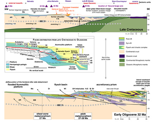
Theoretically, the flexural bulge related to the southward subduction of the Alpine Tethys affected the Briançonnais domain in Late Cretaceous already and could have been responsible for major hiatuses in the sedimentary record at that time and a very condensed section all together (Couches Rouges: Guillaume, 1986). Thereafter it affected the Helvetic margin (fig. 16) creating a general emersion of the Helvetic-Dauphinois and Subalpine domains since Paleocene time (Lihou, 1996, Allen et al., 1991, Burkhard and Sommaruga, 1998). However, Pyrenean inversion within the Helvetic margin and the eastward migration of the Briançonnais peninsula at that time, certainly strongly interfered with the flexural processes creating localised inversions of former tilted blocks (Niesen flysch: (Ackerman, 1986) and Meilleret flysch (Homewood, 1974) (fig. 16).
Figure 16. Reconstruction of the Helvetic margin in Maastrichtian and Early Oligocene
(modified from Stampfli et al., 1998). See text for discussion and references about the timing of events. Stretching factor from Loup (1992). AR, Aiguilles rouges massif; Di, Diablerets nappe domain; DB, Dent Blanche nappe; Le, Lebendun sequence; MB, Mont Blanc massif; MF, Mont Fort nappe; Mo, Morcles nappes domain; Mé-Br, Médianes and Brèches nappes; ML, Monte Leone nappe; Ni, Niesen nappe; N-S, nappes Supérieures; S-C, zone Sion-Courmayeur; S-M, Siviez-Mischabel nappe; SuM, zone sub-Médianes; Ts, Tsaté nappe; V-A, Verampio-Antigorio napes; Wi, Wildhorn nappe domain; ZH-Po, zone Houillère, Pontis nappes.
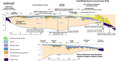
The time of incorporation of the different terrains is well established based on the age of associated flysch deposits (Caron et al., 1989). In the Piemont domain (fig. 14) on a western Alps transect, the Gurnigel flysch was deposited from Maastrichtian until middle Eocene (Caron et al., 1980a; Caron et al., 1980b) and followed by the chaotic complex of likely late Middle Eocene age (Dall'Agnolo, 2000; Steffen et al., 1993), which includes elements from the Briançonnais margin (Couches Rouges, Breccia nappe). On the Briançonnais domain the deposition of the Médianes flysch lasted until Lutetian time (NP 15, 47 to 43 Ma: Guillaume, 1986) it is a rather distal flysch deposit, precluding any deposition on an already detached substratum. Thus the subduction of the Briançonnais domain did not take place before the late Middle Eocene (fig. 17), this is confirmed by metamorphic ages from the Briançonnais basement starting around 38 Ma (Markley et al., 1995).
Figure 17. Reconstruction of the Briançonnais domain in Early Cretaceous and early Middle Eocene
Modified from (Stampfli et al., 1998). See text for discussion and references about the timing of events. Stretching factor from Marchant and Stampfli (1997b).
Slivers of basement with part of their cover were detached from the subducting slab and underplated; they form presently the bulk of the middle Penninic domain (Escher et al., 1997). Part of the cover was detached from the basement and incorporated in the still active accretionary prism to form the future Préalpes Médiannes (Mosar et al.,1996). The exotic Briançonnais sliver was overthrusted on the Valais trough and a Late Eocene mélange is found at its base in the Valais (Pierre Avoi uni, Bagnoud et al. 1998).Along the same suture MORB are found in a few places in the Valais and in eastern Switzerland (in the Bündnerschiefer) (Dürr et al., 1993). They have a signature not different from other Piémont MORB, and as said above are derived from a piece of the Alpine Tethys trapped between the Helvetic and the exotic Briançonnais terrain. The matrix of mélanges found directly under the Briançonnais are only dated in the Pierre Avoi unit in Valais, one cannot exclude that older mélanges (Late Cretaceous) are present, mainly in the Bündnerschiefer domain and related to the Cretaceous translation of the Briançonnais terrain.
Elements from the Valais trough and the distal Helvetic margin were then accreted and are represented by the "Valaisan trilogy" (Aroley, Marmontains, Saint Christophe: Burri, 1958) made of poorly dated deep-sea sediments, outcroping nowadays in the Sion-Courmayeur zone.
Incorporation in the prism of elements pertaining to the Helvetic margin (fig. 12) is well constrained by the ages of the south Helvetic flysch (e.g. Jeanbourquin, 1994; Jeanbourquin and Burri, 1991) and Sardona flysch (in east Switzerland)(Lihou, 1996). It can be placed during or just after the Priabonian since the Ultrahelvetic flysch has been dated as Late Eocene (37 to 33.7 Ma, e.g. Charollais et al., 1993; Kindler, 1988). Most of the attenuated crust from the Helvetic margin was subducted (Burkhard and Sommaruga, 1998).
General metamorphism of the south Helvetic domain spreads from 30 to 20 Ma (cooling ages)(Steck and Hunziker, 1994) and mylonites from the Helvetic nappes have been dated between 32 and 13 Ma (Kirshner et al., 1996).
Further subduction of the thicker part of the margin led to the decoupling of major parts of the crystalline basement represented by the Mont Blanc and Aiguilles Rouges massifs. This decoupling was made possible by the increased heat flux following the Alpine Tethys slab detachment or delamination around 35-33 Ma (Wortel and Spakman, 1992; Stampfli and Marchant, 1995). This delamination corresponds to the emplacement of the peri-Adriatic intrusives (e.g. Bergell intrusion) and the rapid Early Oligocene transgression on the Helvetic domain following temporary de-flexuring of the lower plate. This phenomenon allowed further subduction of 50 to 150 km of European plate (Marchant and Stampfli, 1997b).
Vergence of subduction
As we have seen above, the southward subduction of the Alpine Tethys ocean is related to the history of the Meliata-Maliac and Vardar domain. The change of vergence of the Alpine Tethys subduction westward is directly linked to the connection between the Alps and the Apennines (fig. 12). It must be emphasized here that the Penninic prism is older (Late Cretaceous-Eocene) than the Apenninic one (Oligocene- Pliocene), actually one started when the other one stopped. If there is confusion between the two it is because the Apenninic prism is re-mobilising parts of the Penninic prism as exotic elements (e.g. the Braco ophiolitic ridge; Elter et al., 1966; Hoogenduijn Strating, 1991). These complex situations of duplication of paleogeographic elements led to many palaeogeographic interpretations (most of them done only on 2D cross-sections) not taking into account large-scale lateral displacement of terrains and diachronous subduction events. Most models propose several parallel small oceans, separating even smaller strips of continental crust. These solutions are not feasible, mainly in regard to rheological constraints on plate boundaries and sedimentological evolution of these margins.
In this framework where large scale constraints are taken into account, ophiolites of the Apenninic prism are regarded as mainly derived from the former Alpine prism which collided with the Iberic plate in Corsica and Calabria in Eocene times (fig. 12). These oceanic elements were re-mobilised when the remnant Alpine Tethys oceanic domain (Ligurian basin) south of the Iberic plate started to subduct northward.