The general tectonic setting around the Tethys during this important time interval appears as an Early Cretaceous prolongation of the kinematic pattern that characterized the Jurassic. However, its upper limit marks the epilogue of the tectonic history that started in the Middle Jurassic and lasted about 55 Myrs. Three stages are comprised in this phase: from chron M10 (131.9 Ma, Valanginian-Hauterivian boundary) to chron M9 (130.0 Ma, Lower Hauterivian-Upper Hauterivian boundary), from 130.0 Ma to chron M4 (126.7 Ma, Hauterivian-Barremian boundary), and from 126.7 Ma to chron M0 (120.4 Ma, Barremian-Aptian boundary).
A first important event that occurred during this phase is represented by the onset of rifting and seafloor spreading in the North Atlantic since 130.0 Ma [Rowley and Lottes, 1988]. However, in spite of the relevance of this event at global scale and the apparent synchronism, it can be shown that it did not trigger the mechanism of Alpine subduction during the Lower Aptian. This aspect will be discussed further in this section. Another feature of this time period is associated with the weak compressional setting that established in the Liguride Basin (Fig. 13), though the predicted total amount of shortening (about 67 Km) could be too small for a field evidence of this event. Similarly, the very small amount of extension predicted by the model for the southern margin of Iberia can be hardly observed through geological studies. In general, most of the tectonic activity around Iberia continued to occur at the northern transtensional boundary with the Eurasian plate. In this region two important basins formed that are well documented in the geologic literature, the Valais trough and the Asturian basin. To the East, the Valais oceanic trough opened by separation of the Sardinia-Corsica-Briançonnais domains from the southern French margin [Stampfli et al., 1998]. The model proposed in this paper predicts that about 200 Km of new oceanic crust formed between the northeastern margin of Iberia and Eurasia during this phase. At the western side, geologic and structural data from the Asturian region indicate that small rift basins formed at the northern margin of Iberia after the Late Jurassic [Lepvrier and Martínez-García, 1990], several million years before the onset of seafloor spreading in the Biscay Bay [Srivastava et al., 1990].
Figure 13. Reconstruction at 120.4 Ma (Lower Aptian)
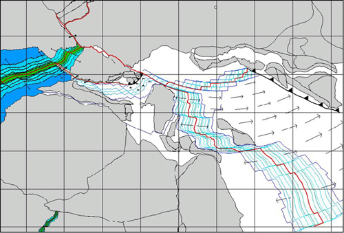
Vectors represent direction and magnitude of the relative velocity field between conjugate pairs of plates. Blue lines represent the modeled 172.0 Ma, 170.0 Ma, M25, M21, M16 and M10 isochrons. The 130.0 Ma and M4 isochrons are indicated in green. The location of the Euler pole of relative convergence between Vardar and Eurasia is marked by a small empty circle.
During the first two stages, between anomalies M10 (131.9 Ma) and M4 (126.7 Ma), the spreading rate in the southern Central Atlantic slowed again, only 16.80 mm/yr with respect to the 30 mm/yr of the previous phase. However, it returned to be 30 mm/yr during the third stage. At the end of the phase (120.4 Ma, Barremian-Aptian boundary) the Alpine Tethys and the Inner Tauride Ocean reached their maximum extensions, respectively 1400 and 1100 Km.
The acceleration field at 120.4 Ma (Barremian-Aptian boundary) is illustrated in Figure 14. The absolute variations of velocity (that is, relative to the spin axis) of Eurasia and North America are shown in the upper part of this map. They are almost identical, though Eurasia was moving with respect to N. America at that time. The anti-pole of this absolute acceleration field was located in southern Morocco (24.03N,13.48E), with a magnitude of clockwise rotation equal to 0.36°/Myr. Therefore, the ongoing separation of Eurasia from the North American craton did not affect the establishment of a strong compressional field in the Tethyan realm, as the two plates accelerated with the same pole and magnitude. This event generated at the same time a strong pulse in the spreading rates of the Central Atlantic and the onset of the Alpine collision. The acceleration of Africa with respect to Eurasia is shown in Figure 14 it is apparent that such pulse of convergence could not be compensated by a slower spreading rate of the Vardar ridge. Hence, the entire system of spreading segments collapsed. According to the model of Robertson and Dixon [1984], a long slice of ophiolites should have formed as a consequence of this Neothetyan ridge collapse, consistently with models that predict at least two distinct root-zones for the Turkish ophiolites [e.g., Çengör and Yilmaz, 1981 ; Robertson and Dixon, 1984]. Therefore, our model confirms that the Neotethyan oceanic seaway that formed between Sakarya-Kirsehir and the Menderes-Tauride platform during the Jurassic and the Early Cretaceous, herein referred to as the “Inner Tauride Ocean”, was the source zone for the ophiolites of the Central Anatolia, which were emplaced onto the suture between these blocks during the Late-Cretaceous-Eocene collision.
Figure 14. Acceleration field at 120.4 Ma (Lower Aptian)

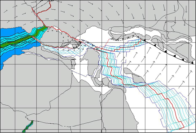
Vectors on N. America and Eurasia represent direction and magnitude of the absolute acceleration field of these plates. Vectors in the Eastern Tethys represent the acceleration field of Northeast Africa with respect to Eurasia. Vectors on Iberia are relative to Eurasia. Finally, the acceleration field in Western Mediterranean is relative to Iberia. A small circle represents the Euler pole of acceleration of N. Africa woth respect to Eurasia.