Different interpretations have been proposed concerning emplacement and polarity of subduction in the Neo-Tethys Ocean during the Mid-Cretaceous. The hypothesis of arc emplacement on the northern rim of the Indian plate, as a result of a south-dipping subduction, is mainly supported by Pb isotopic values for Kohistan lavas (Khan et al., 1997), which appear to plot within the range defined for the DUPAL anomaly. This has led these authors to propose that the arc was emplaced above the DUPAL mantle anomaly in the current South Indian Ocean (Hart, 1984).
Other explanations are plausible. Our geochemical study of Ladakh paleo-arc lavas in NE Pakistan and NW India (Fig. 2; summarised in Rolland et al., 2000; 2002a) suggests that similar Pb isotopic data in the lavas can be produced by intense interaction between slab melts and overlying mantle in the arc source region. These data are briefly summarised below. Lavas from the west Pakistan side of the Ladakh Arc can be separated mainly into two groups: (1) the Northern Group of back-arc tholeiites [0.5<(La/Yb)N<1.4; 0.3<(Nb/La)N<1.4; 4<εNd<8; 38.66<208Pb/204Pb<38.80] and (2) the Southern Group of arc tholeiites [1.8<(La/Yb)N<3.9; 0.1<(Nb/La)N<0.6; 5<εNd<6; 38.40<208Pb/204Pb<38.66]. Lavas from the Indian east side of the Ladakh Arc show a simple series of more evolved arc volcanics ranging from basalts to rhyolites [basalts and basaltic andesites: 2.5<(La/Yb)N<5.7; 0.4<(Nb/La)N<0.5; 1.8<εNd<5.5; 38.70<208Pb/204Pb<38.80]. These geochemical features are comparable to those for the Kohistan lavas, and provide support for correlating of Ladakh and Kohistan paleo-arc series. Ladakh Arc lavas have similarly high Pb isotopic ratios. In addition to these relatively classic arc lavas, an adakitic lava [(La/Yb)N=55.8; (Nb/La)N=0.3; εNd=1.7; 208Pb/204Pb=39.00] and a Mg-poor, Nb-rich basalt [(La/Yb)N=4.6; (Nb/La)N=1.3; εNd=-2; 208Pb/204Pb=39.07] are spatially associated with the tholeiitic arc lavas (Rolland et al., 2002a). Nb-rich lavas are also found interlayered within the mainly sedimentary Katzarah formation, further south [3.4<(La/Yb)N<9.8; 1.4<(Nb/La)N<2.1; 3<εNd<5], including radiogenic Pb lavas [39.31<208Pb/204Pb<39.51] and less radiogenic Pb lavas [38.31<208Pb/204Pb<38.55]. Adakitic and Nb-rich lava associations, within the basalt to andesite arc lavas, have recently been interpreted to result from slab-melting and subsequent interaction with the overlying mantle (e.g., Sajona et al., 1996). Such processes are also indicated by Pb isotopic ratios discussed below.
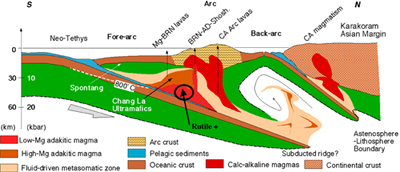
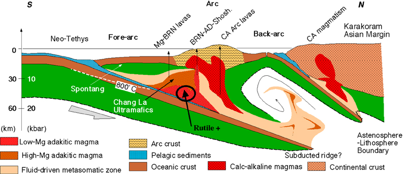
All the lavas from Kohistan (Khan et al., 1997) and Ladakh (Rolland et al., 2002a) display very high Pb, Sr and low Nd isotopic ratios, in the range of the DUPAL anomaly values. The occurrence of the DUPAL anomaly (e.g., Hart, 1984) is not as restricted as supposed by Khan et al. (1997), because this isotopic anomaly has been noticed in other areas of the SE Asia region (e.g., Tu et al., 1991). Comparable radiogenic Pb isotopic ratios can result from interaction of slab melts with the overlying mantle. All Kohistan and Ladakh lavas plot along a mixing curve between MORB and pelagic sediments end-members on the εNd vs. 206Pb/204Pb diagram (figure 4). Pb isotopic compositions of all the lavas, and in particular the radiogenic Nb-rich and adakitic lavas, suggest mixing between depleted mantle similar to the Indian MORB mantle and 0.1-5% of enriched components similar to pelagic sediments. Such inputs of slab components are more likely due to slab melting effects, also supported by the presence of adakitic and Nb-rich volcanism. For some Nb-rich lavas (Katzarah lavas), the initial isotopic features may be overprinted by effects of intense melting in the overlying mantle region, as suggested by their picritic composition. This might be due to their southern, possibly fore-arc, origin.
Figure 4. eNd vs. 206Pb/204Pb plot of the Ladakh lavas
The field of Kohistan lavas (Khan et al., 1997) is shown for comparison. AD: adakite; NRB: Nb-rich basalt; KF: Katzarah Formation; SG: Southern Group. The mixing curve is computed using compositions of least radiogenic values of the Indian MORB component (εNd = 10; 206Pb/204Pb = 17.31; Pb = 0.03 ppm; Nd = 0.8 ppm), and two extreme values of pelagic sediments (εNd = -9; 206Pb/204Pb = 18.56 & 19; Pb = 9 & 60 ppm; Nd = 30 ppm; Ben Othman et al., 1989). Note that even using a depleted MORB composition, small contributions of pelagic sediments can explain the radiogenic features of Ladakh and Kohistan lavas. This input is in the range 0.1-5%, being highest for Nb-rich basalt and adakite of the Southern Group, which are likely formed by slab-melt / mantle interactions. After Rolland et al. (2002a), modified.
Consequently, these geochemical data reflect intense mantle-slab melt interactions due to subducted crust melting. A reconstruction sketch of the arc is proposed on figure 5. Thermo-barometric conditions required in the case of slab melting are those prevailing in young (< 15-20 Ma) subducted crust (e.g., Martin, 1999). Nb-Ti-rich and adakitic lavas have been described in current volcanic arc settings where a young (< 5 Ma) oceanic crust is being subducted (e.g., Solomon Islands: Petterson et al., 1999; Mindanao island: Sajona et al., 1996; Cascade Range: Leeman et al., 1990).
Different interpretations have been proposed concerning the presence (Pudsey, 1986; Srimal, 1986; Coward et al., 1986; Srimal et al., 1987; Khan et al., 1994; 1996; Treloar et al., 1996; Rolland et al., 2000) or absence (Rai, 1982; 1983; Khan et al., 1997) of a back-arc basin along northern Kohistan-Ladakh series, mirroring discussion about the emplacement and polarity of subduction.
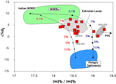
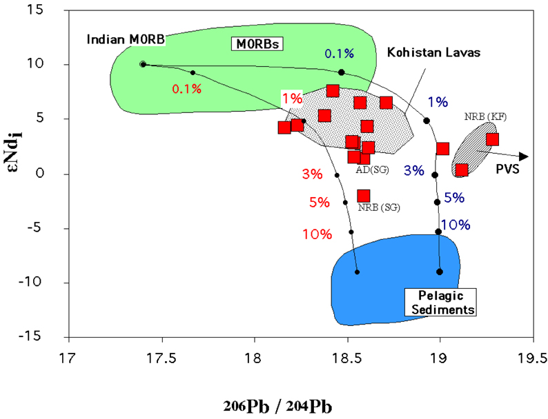
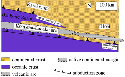
The geochemistry (summarised above) and lithology of the lavas clearly show that they were intra-oceanic in their Kohistan and western Ladakh parts, with both arc and back-arc marine environments. The lithology of the units described along the Shyok Suture Zone in Ladakh (Rolland et al., 2000) and in Kohistan (Pudsey, 1986) shows that two types of units (arc and back-arc) are present. The Southern Group units are mainly made of lava flows, interlayered with minor tuff and local bombs/lapilli layers. In contrast, the northern group units are made of transported blocks of lava in a tuff matrix, suggesting emplacement in a marginal basin. The geochemistry of the Southern Group lavas is typical of arc lavas, with enrichments in LREE, LILE and Nb-Ta depletions relatively to N-MORB concentrations, while that of Northern Group lavas, with compositions intermediate between N-MORB and arc lavas, is suggestive of a back-arc environment. To the east of the Ladakh terrane, the continental affinity of Indian Ladakh lavas and sediments show that the eastern part of the arc evolved to Andean series, possibly continental based, similar to southern Tibet (Coulon et al., 1986). This evolution from oceanic to continental settings suggest north-dipping subduction, oblique to the Asian margin (Fig. 6; Rolland et al., 2000).
Figure 6. Geometry of the Karakoram-Tibet Asian margin in Middle Cretaceous
Geometry of the Karakoram-Tibet Asian margin in Middle Cretaceous, as inferred by geochemical and lithological data, after Rolland et al. (2000).
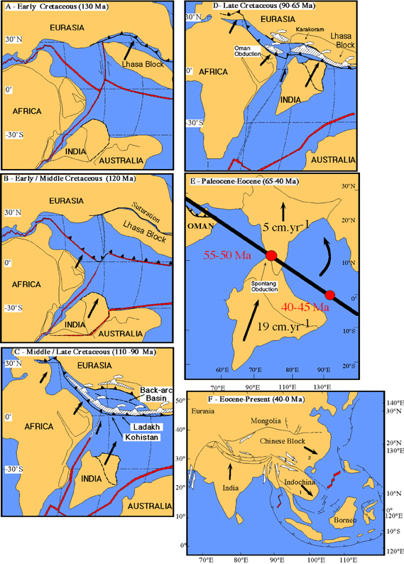
In the wider context of the Neo-Tethys Ocean in the Middle Cretaceous, the data presented above reflect the succession of two major tectonic events that may be combined to explain the subduction of such a young lithosphere (Fig. 7). Prior to arc formation rapid subduction of the Tangulla-Waser Ocean, north of the Karakoram-Lhasa block led to accretion of this block against the Asian margin during the Early Cretaceous (Fig. 7A, Besse et al., 1988). This accretion may have blocked the only free (Asian) boundary of the Tethyan system, where oceanic crust could be easily subducted. At this very critical moment, India and Africa started their drift towards the north (rapid for India, up to 19 cm.yr-1 in Late Cretaceous-Early Tertiary; Patriat & Achache, 1984; Klootwijk et al., 1992). In this particular tectonic context, the Neo-Tethys oceanic ridge may have been the weakest plate boundary, where subduction could be more easily initiated (Fig. 7B), comparable to the model proposed for the initiation of the Oman obduction (Coleman, 1981; Boudier and Coleman, 1981; Pearce et al., 1981) with the formation of the Kohistan-Ladakh arc at 100-95 Ma (Fig. 7C; see Boudier et al., 1985 and Thomas et al., 1988 for Oman).
Figure 7. Tectonic reconstruction proposed for intra-oceanic stages of the India-Asia convergence

Double stripped lines and red colour represent mid-oceanic ridges, single bold lines (black) represent subduction zones and hatched domains to volcanic arc lineaments and arrows represent direction and norm of tectonic blocks motions from Patriat and Achache (1984). Approximate position of continents is from Scotese and Golonka (1992) and Van der Voo et al. (1999), and position of the Lhasa block is from Sengör and Natal’in (1996). The shape of India is according to Matte et al. (1997). The position of the Neotethys ridge is inferred from the relative position of Lhasa and India, and from the timing of emplacement of the Oman ophiolite (Coleman, 1981; Boudier and Coleman, 1981). A, Early/Middle Cretaceous: Accretion of the Lhasa block to the Eurasian margin. B, Middle Cretaceous: this accretion blocked the free boundary of the system while fast northward drift of India was initiated. In this context, the oceanic ridge may have been the weakest plate boundary, where subduction has been initiated. C, Middle/Late Cretaceous: formation of the Kohistan-Ladakh arc and back-arc. D, Late Cretaceous: back-arc closure and arc accretion along the Karakoram margin. E, India-Asia collision: the convergence is accommodated by lithospheric-scale partitioning between horizontal shortening (folding + thrusting) and strike-slip faulting (figure E after Tapponnier et al., 1986).
On the Karakoram margin, calc-alkaline magmatism, occurred contemporaneously with the formation of the Kohistan-Ladakh Arc. This magmatism, interpreted as supra-subductive (Debon et al., 1987; Crawford & Searle, 1992), implies existence of another subduction zone along the Karakoram Asian margin (Fig. 7C) responsible for formation of the Karakoram Batholith (Debon et al., 1987). This magmatism evolves from calc-alkaline to alkaline at ~ 88 Ma (Debon & Khan, 1996), which suggests deepening of the source-region and steepening of the Benioff plane directly preceding arc-continent accretion.
Accretion of the Kohistan-Ladakh Arc to the Karakoram Asian margin occurred in the Late Cretaceous (Fig. 7D; Petterson & Windley, 1985; Weinberg et al., 2000). At this stage, there is only one subduction zone extending at least from the Middle East to the Tibet regions. Arc accretion may not have happened simultaneously due to the obliquity of the arc lineament with respect to the continental margin. It is dated at 75-65 Ma by plutonism developing along the Shyok Suture Zone, earlier in Kohistan (~ 75 Ma, Petterson & Windley, 1985), and later in eastern Ladakh (Tirit granite, 73.6-68 Ma; Weinberg & Dunlap, 2000; Weinberg et al., 2000). The stages that directly preceded, or accompanied, the accretion, are coeval with intense magmatism, with emplacement of granodiorite to granite plutons along the Kohistan-Ladakh Batholith. The volume of this later magmatism is far more important in Ladakh than in Kohistan. This late magmatism largely overprints the arc structure, being responsible for granulite-facies metamorphism in the central part of Ladakh (Raz & Honegger, 1989; Rolland et al., 2000) and amphibolite to epidote-amphibolite metamorphism along the northern suture (Hanson, 1989; Rolfo et al., 1997). Simultaneously with this metamorphism, different units of the paleo-arc series, belonging to arc and back-arc series, were stacked along southwest-vergent thrusts floored by serpentinites. The Karakoram and Kohistan-Ladakh terranes ultimately formed a completely accreted crustal section.
The collision of India and Asia occurred between 65 and 55 Ma in NW Himalaya, for a detailed review of the data and references concerning the India-Asia collision, see Rowley (1996) and Searle et al. (1997; 1999). Magnetic studies have evidenced an abrupt decrease in convergence rate, from 18-19.5 cm.yr-1 to 4.5 cm.yr-1, at ~ 50 Ma for Patriat & Achache (1984), 50-55 Ma for Klootwijk et al. (1992), and 57 ± 3 Ma for Acton (1999). These age estimates are interpreted to date the initiation of India - Asia collision. This drop in convergence rate coincides with a reduction in the spreading rate of SW and central Mid-Indian Ocean ridge at 56.1 – 50.3 Ma (Molnar & Tapponnier, 1975; Patriat & Achache, 1984; Patriat et al., 1985). The collision occurred initially in the NW and propagated to the SE (Fig. 7D; Bassoullet et al., 1981; Blondeau et al., 1986; Klootwijk et al., 1992; Guillot et al., 1999). This diachronous collision may be due to the initial shape of the Indian continent, colliding with NW-SE Asian margin (thick line on Fig. 7E). In a first stage, NW Indian continental crust was subducted to a minimum depth of 60 km, as indicated by eclogitic metamorphism documented in the Tso Morari area at ~ 55 Ma (P = 20 ± 2 kbar, T = 550 ± 50°C, Guillot et al., 1997; de Sigoyer et al., 1997; 2000). Subsequently, in the Palaeocene, the Kohistan-Ladakh sequences were obducted (in two stages) onto the Indian margin (Garzanti et al., 1987; Reuber et al., 1987); this is notably later than the obduction of the Oman ophiolite on the African realm (Latest Maestrichtian; Michard et al., 1984; Lippard et al., 1986; Goffé et al., 1988). In the meantime, and until 50 Ma, granitic magmatism still occurred in the Ladakh terrane (Weinberg & Dunlap, 2000). Locally, these last granitic melts bear a strong continental crust affinity (εNd = -7.5, Rolland et al., 2002a). This magmatic stage could thus correspond to partial melting of a continental crustal basement, or be due to melting of the paleo-arc siliceous sediments. The presence of such a contrasted metamorphic conditions between the HT-MP Kohistan-Ladakh terrane and the LT-HP subducted Indian slab is probably due to the efficient “thermal screen” provided by the thick sequence of ultramafic lithologies (i.e. the serpentinites) in between the two zones (e.g., Treloar, 1997). Such a contrast does not exist in eastern Himalaya (Lombardo & Rolfo, 2000), where eclogites have been totally transformed into granulites.
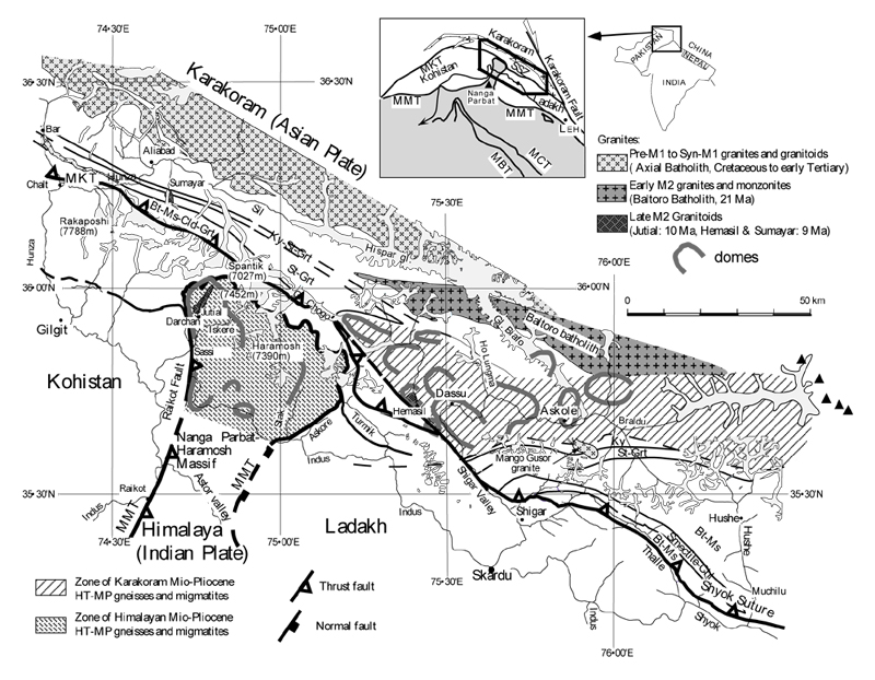
The earlier M1 structures found in the Karakoram area are NW-SE thrusts, schistosity and metamorphic isograds, oriented parallel to the Shyok Suture, and thus reflective of a stage of NE-SW shortening (Hanson, 1989; Allen & Chamberlain, 1991; Searle et al., 1999; Rolland et al., 2001). The M1 metamorphic grade increases towards the NE, reaching MP amphibolitic facies conditions (sillimanite zone, T = 650°C, P = 10 kbar) close to the contact with the axial batholith (Bertrand et al., 1988; Searle et al., 1989; Lemennicier et al., 1996). These structures are compatible with thickening of the Karakoram, with deep crustal levels thrusted over shallower ones.
Figure 8. Geological and metamorphic sketch map of the S-Karakorum margin after Rolland et al. (2001)
Main tectonic contacts are the Main Boundary Thrust (MBT), the Main Central Thrust (MCT), the Main Mantle Thrust (MMT), the Shyok Suture Zone (SSZ), and the Main Karakorum Thrust (MKT). Full triangles are summits above 8000 meters.
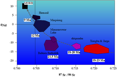
By 41 Ma, India was fully colliding with Asia on 2000 km length (Rowley, 1996), the collision propagating from NW to SE. Between 57 and 41 Ma, the direction of India-Asia convergence had rotated from NNE-SSW to N-S (e.g., Guillot et al. 1999 and references therein). In the NW Syntaxis, this change in shortening direction is emphasised by the transition from M1 to M2 (Fig. 8). The Karakoram M1 structural pattern is crosscut by the 37 Ma Mango Gusar granite and by the 25-21 Baltoro granite intrusions (Parrish & Tirrul, 1989; Searle et al., 1989; Schärer et al., 1990). One of the most striking effect of the M2 event is the formation of migmatic domes, aligned E-W. It has been proposed for syntaxes areas (Namche Barwa), that thermal weakening following HT metamorphism in mid-crustal levels could have led to doming via fold amplification (Burg et al., 1997; Burg & Podladchikov, 1999). This heating is closely associated (spatially and temporally) to high-K mantle-derived plutons (see review in Mahéo et al., 2002). This mantle-derived magmatism is found all along the southern Tibetan margin (Turner et al., 1996; Miller et al., 1999). Compiled isotopic and age data from Mio-Pliocene magmatic rocks that were emplaced along the Tibet-Karakoram margin are presented on figure 9, which shows that mixed mantle-crust magmatism occurred since the intrusion of the Baltoro Granite at 21-25 Ma. In younging order, the magmatic intrusions are increasingly more mantle derived, suggesting less efficient mixing with the crustal component, with the youngest Hemasil Syenite, dated at 9 Ma (Ar-Ar Hornblende, Villa et al., 1996), bearing an isotopic signature close to that of MORBs (Lemennicier, 1996). The Hemasil Syenite is closely associated with the occurrence of high-temperature M2 metamorphism in the Dassu Dome area, peaking at 750-800°C and 6 kbar (Fig. 10; Rolland et al., 2001) and dated at 6-7 Ma (U-Pb on zircon, Smith, 1993). On figure 11, the P-T path for the Karakoram domes area (Askole-Dassu) is compared to the path for the High Himalayan Crystalline and the NPH Massif. The P-T path drawn for the domes area of the Karakoram indicates strong heating at only 6 kbar, while the exhumation rate was 3 mm.yr-1. The P-T path of the Nanga Parbat granulites, in contrast, is characterised by nearly adiabatic decompression due to a very fast exhumation rate (7 mm.yr-1, Zeitler et al., 1993). An additional source of heat must therefore be advocated for the Karakoram domes. The spatial and temporal relationships of metamorphic rocks and mantle-derived magmas in this zone suggests an efficient heat advection process from the mantle via magmas. Such relationships between HT metamorphism and mantle magmatism have been observed and interpreted, on the basis of numerical simulations, as the result of slab detachment processes by Davies & Blanckenburg (1995). For the NW Himalaya this hypothesis is supported by seismic data, which show an interruption of seismic activity at a depth of 170 km along the subducting Indian slab (Chatelain et al., 1981). A similar interpretation can be made from the tomographic data of Van der Voo et al. (1999), reinterpreted by Chemenda et al. (2000). The latter authors have experimentally simulated Indian slab detachment, at a state of convergence equivalent to 20-25 Ma.
Figure 9. εNdi vs. 87Sr/86Sr diagram showing isotopic composition of Miocene magmatic rocks from the Asian margin (Tibet + Karakoram)
Data from Searle et al. (1992), Lemennicier (1996), Turner et al. (1996), Miller et al. (1999).
Figure 10. P-T path of M2 metamorphic event in Dassu and Askole domes
P-T path of M2 metamorphic event in Dassu and Askole domes (after Rolland et al., 2001).
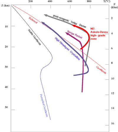
Figure 11. Stable, perturbed and relaxed geotherms
Stable, perturbed and relaxed geotherms compared to P-T paths obtained in the Karakoram (M2 Domes; Rolland et al., 2001), in the Nanga Parbat (Whittington et al., 1998), for the Miocene syn-stacking metamorphism in the High-Himalayan Crystalline (Guillot, 1999), and for the Hercynian post-orogenic metamorphism in the French Central Massif (Gardien et al., 1997).
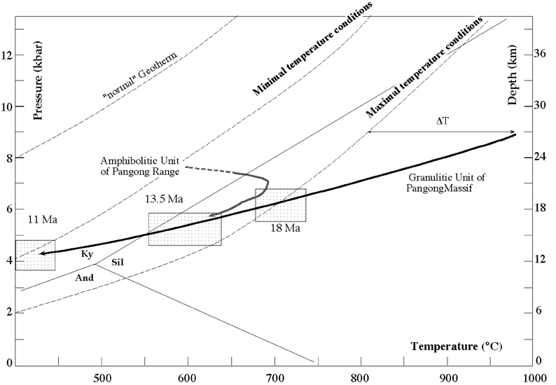
Since c. 40 Ma, a considerable part of the convergence is accommodated by great strike-slip faults peripheral to the Himalayan Orogen, such as the Chaman, Altyn Tagh, Karakoram and Red River faults (Fig. 7E; Molnar & Tapponnier, 1975; Tapponnier & Molnar, 1977; Tapponnier et al., 1986; Peltzer & Tapponnier, 1988; Armijo et al., 1989). Time of metamorphism and uplift in the metamorphic core of the Pangong Range (Figs. 12 & 13), can be used to infer the depth and slip rate of the Karakoram fault. The Pangong Range was successively equilibrated in the granulite, amphibolite and greenschist facies. Granulite facies conditions of ~ 800°C were reached at relatively shallow depths (6 kbar, 18 km), and the subsequently estimated thermal gradient is high at upper crustal levels (45-55°C.km-1 at 5-20 km) within the fault zone (Rolland & Pêcher, 2001). These temperature conditions are more than 100°C above estimated temperatures obtained from crustal-scale shear heating modelling (Leloup et al., 1999). Additional heat input is thus required directly in the fault zone. It could be hypothesised that the full Lithosphere penetration of the shear zone, which divides two lithospheric blocks, allows efficient heat advection from the mantle, similar to the Red River and Altyn Tagh faults (Leloup et al., 1999; Wittingler et al., 1998).
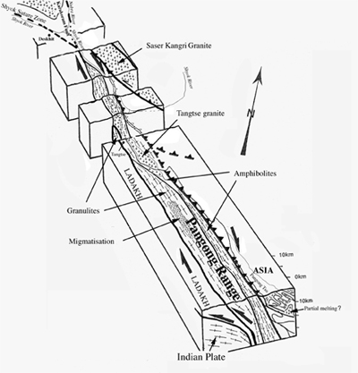
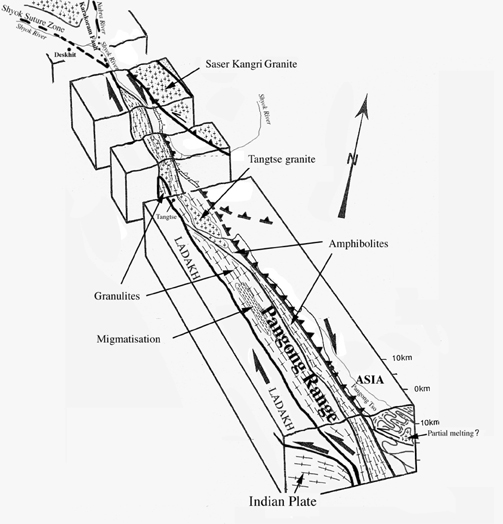
Figure 12. Karakoram Fault structure
Schematic 3D interpretative view of the Karakoram Fault structure along Nubra, Shyok and Pangong Valleys.
The progress of the Pangong Range exhumation can be constrained by several geo-chronometers. From Ar-Ar analysis of the granulite facies rocks, the age of peak metamorphism is not well constrained yet, older than at least 32 Ma (Rolland, 2000). Ar-Ar dating of these rocks shows however a strong resetting of the Ar-amphibole chronometer at 18-13.5 Ma in the amphibolite facies. A similar age of 18 Ma has been obtained from the U-Pb zircon, on the Tangtse Granite emplaced at the contact between granulite and amphibolite units (Searle et al., 1998). Subsequent greenschist facies metamorphism is dated at 11.3-11.4 Ma from Ar-Ar dating on biotite and muscovite by Searle et al. (1998). The age and P-T estimates of the amphibolite facies, combined with closure temperature estimates reported in Villa (1998), suggest that the Pangong exhumed at a mean rate of 1 mm.yr-1. A subsequent horizontal slip rate estimate of 1.7 mm.yr-1 for the Pangong Range during its past 18 Ma exhumation can be derived from the 30°NW plunge of mineral lineations. The 300 km total slip of the Karakoram Fault, deduced from the lateral correlation of the Karakoram and Lhasa blocks (Rolland et al., 2002b), such slip rates imply:
(1) Initiation of the Karakoram Fault at the onset of the Karakoram-Lhasa block accretion to the Asian margin (at t > 130 Ma).
(2) If instead an age of 32-40 Ma is accepted for the initiation of the Karakoram Fault, faster slip rates of 7.5-10 mm.yr-1 would be estimated. In that case, the slip rate estimates from the P-T-t path of the Pangong Range would be underestimated.
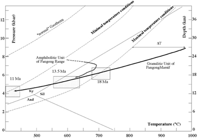
Figure 13. P-T-t path obtained in the Pangong Range (after Rolland and Pêcher, 2001)
Minimal and Maximal PT conditions obtained for shear heating modelling by Leloup et al. (1999). U-Pb and Ar-Ar ages from Searle et al. (1998), and Rolland (2000).