Introduction
The high Agri River valley (Alta Val dÕAgri, Lucania, southern Italy; Fig. 1a) is one of the most significant areas of the southern Apennines from a seismotectonic point of view. An active fault system is hosted in the valley and one of the most destructive earthquakes in the Italian history struck the area in 1857 (equivalent magnitude, derived from intensity data by applying the method proposed by Gasperini et al., 1999: Me 6.98; maximum intensity of damage, expressed according to the MCS scale: Imax XI; Gruppo di Lavoro CPTI, 1999).
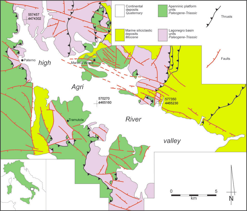 |
| Figure 1(a). Schematic geological map of the high Agri River valley area. (Enlargement) |
At present, no focal mechanisms are available for the study area, neither for the too old 1857 event, nor for the low and scattered instrumental seismicity recorded in recent years (ING-GNDT, 2001; Di Bucci, unpublished data). Therefore, all the different models suggested for the seismogenic structure potentially responsible for the 1857 earthquake are based on geological surveys, geomorphology, mesostructural analysis, as well as macroseismic data. A first hypothesis was proposed by Pantosti and Valensise (1988). They suggested a NW-SE striking, NE-dipping normal fault of a length exceeding 55 km (probably formed by two sub-segments). This model was mainly based on geomorphological and historical data. Again, geomorphological studies and historical data led Benedetti et al. (1998) to a different model. They outlined the noticeable development of Quaternary normal faults along the northeastern side of the high Agri River valley (Fig. 1b-e) and suggested that these are directly related with the seismogenic structure of the 1857 event. In this case, the master fault should also be NW-SE oriented, but SW-dipping. This later interpretation is also adopted by Michetti et al. (2000). Recent tectonic displacement on the faults located along the northeastern side of the valley was documented by Giano et al. (2000), who recognised Upper Pleistocene paleosoils involved in faulting. The importance of these faults for the present-day tectonic activity of the area was also outlined by Cello et al. (2000), who suggested a left-lateral strike-slip motion along a N120¡-oriented fault system.
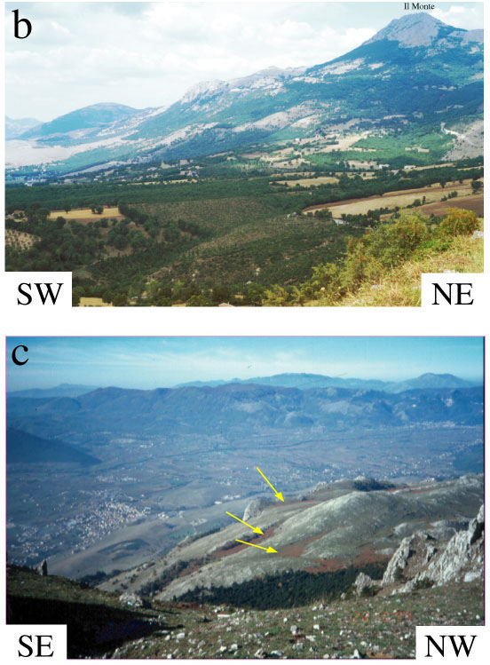 |
| Figure 1(b). View of the northeastern side of the high Agri River valley, showing stepped morphology controlled by extensional fault scarps. (c) View of the valley from ÔIl MonteÕ, showing southwestward down-faulting of karst surfaces (arrowed) in Mesozoic limestones. |
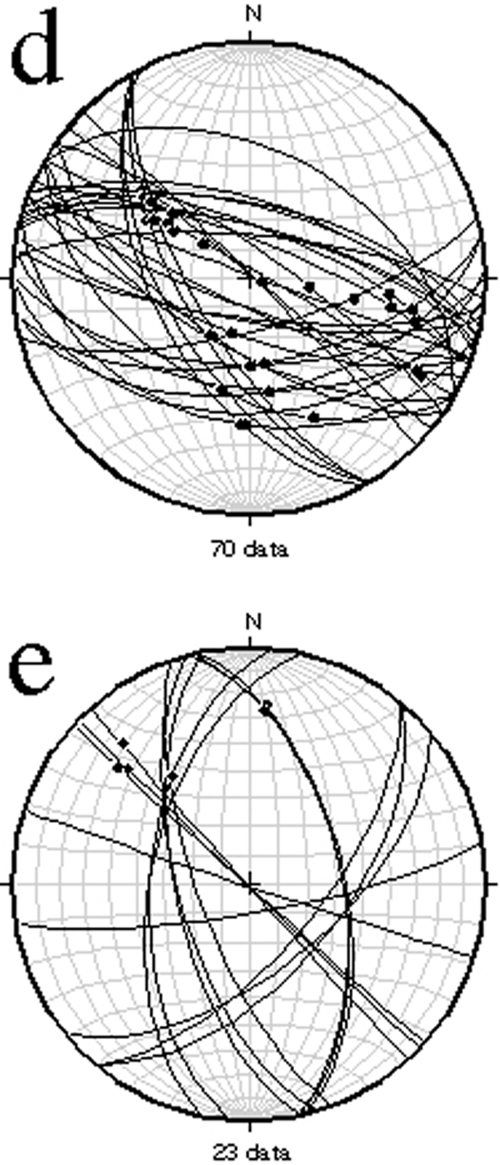 |
| Figure 1(d)-(e). Orientation data for Quaternary faults (lower hemisphere, equal-area projections). Great circles are fault planes from the northeastern (d) and southwestern (e) sides of the valley. Black dots are slip vectors determined from shear fibres or striae on slickenside surfaces. Fault kinematics is extensional or oblique-slip with extensional components in all cases. Compare dispersed fault pattern from the southwestern side of the valley (e) with consistent WNW-ESE dominant trends recorded from the northeastern, fault-bounded valley flank (d). (Enlargement) |
This short review shows that all the models are based on surface data and that, at least for the high Agri River valley region, this kind of data alone is not sufficient to identify the geometry of the seismogenic structure (strong earthquake hypocentres in the southern Apennines usually occur at a depth of about 10 km; Boschi et al., 1993). However, a relatively large amount of published subsurface data is available for the study area, which has been the subject of intense hydrocarbon exploration and production (e.g. Mostardini and Merlini, 1986; Carbone et al., 1991; Casero et al., 1991; Roure et al., 1991; Mazzoli et al., 2000; 2001; Menardi Noguera and Rea, 2000; Morandi and Ceragioli, 2000, 2002; Butler et al., in press). In this work we integrate surface geology with published subsurface data and propose a new 3D model for the fault system. This model (Figs. 2-6) was built, based on a series of deep geological sections across the study area, using the software 2D Move and 3D Move (Midland Valley Exploration Ltd.).
We suggest that, at depth, the high Agri River valley active fault system is related to a SW dipping master fault; this fault was probably responsible for the 1857 earthquake (Fig. 2). Our model represents the first attempt to reconstruct the 3D geometry of an active fault system in a seismic area such as Italy and, therefore, also constitutes a challenge for seismic hazard and scenarios studies.
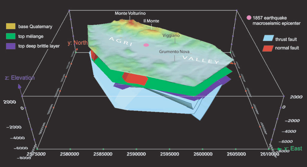 |
| Figure 2. Three-dimensional structural model of the high Agri River valley area: general view from the South. Location of macroseismic epicentre of the 1857 earthquake (after Gruppo di Lavoro CPTI, 1999) also shown. (Enlargement) |