Historically, geologists used stereoscopes to study large-scale aerial photographs, as an aid to field reconnaissance (Pillmore 1989) and to map regional stratigraphic frameworks on well exposed geological outcrops (e.g. Sgavetti 1992; Lebel and de Roza 1999). Technological advances using analytical plotters interfaced with computers, could only generate Digital Elevation Models (DEMs) as the final product (Pringle et al. in review).
Digital photogrammetry, using VirtuoZo software supplied by Supresoft Inc., converts scanned aerial photographic images into 3D digital models. Digital Terrain Models (DTMs) are produced, which give more accurate representation of the topographic surface, with the image pixel positions re-projected to form a geographically referenced Ortho-Rectified Image (ORI) in 2D. The generation of ORIs from stereo photographs removes inaccuracies associated with lens distortion and other photographic effects, which is vital for accurate measurements. The ORIs are then draped over the interpolated DEMs to produce a three dimensional, high resolution, dynamic stereo-model (Figure 2). Multiple users can view the same image for example, by wearing polarised viewing glasses combined with a stereoscopic screen filter which covers the workstation screen (Figure 3). The 3-D model and rectified photographic imagery can then be shared with a wider, non-specialised peer group, none of whom need photogrammetric skills.
Figure 2. Photogrammetric mapping of stratigraphic boundaries
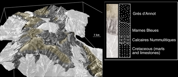
Photogrammetric mapping of stratigraphic boundaries in the Tertiary deep-marine sediments and underlying faulted Cretaceous basement in the Grand Coyer Sub-basin, SE France. The model has been interrogated for stratigraphic surfaces and large-scale fault geometries, then the ortho-rectified image has been appropriately coloured and re-imported into the stereo-model.
Figure 3. Photogrammetric mapping of 3-D digital models
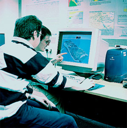
Photogrammetric mapping of 3-D digital models in action by team members. The models once completed can be viewed in stereo by use of a Nu-vision screen and polarised glasses, and can be freely rotated and viewed from any desired orientation.