Paleomagnetic constraints from Avalonia
We used our models to construct the paleolatitudinal positions for West and East Avalonia (representative points are 46°N, 60°W and 52°N, 0°E, respectively) (Fig. 6). Unfortunately there are no high-quality paleomagnetic data for Avalonia with well constrained ages older than 600 Ma. We have shown available magnetic paleolatitudes (Fig. 6) using the results with reliability criteria of Q>2 (Van der Voo, 1990). These paleolatitudes are systematically lower than those predicted by our models. This discrepancy could be reduced slightly if the Amazonia-Laurentia fit of Dalziel (1997) is used. However, the apparent lack of correlation between Dalradian of Scotland and the Peruvian Arequipa massif, together with the discovery of the Neoproterozoic Maraon belt in the northern Andes suggests this configuration requires substantial modification. In addition, this fit contradicts the abundant Neoproterozoic paleomagnetic data from Laurentia and Baltica (e.g., Weil et al., 1998; Pisarevsky and Bylund, 1998). Hence, a suggestion from both approaches is that either Laurentia had a more complicated movement history between 720 and 615 Ma than is currently constrained by the available data, or the configuration of Laurentia-West Gondwana-Avalonia on many reconstructions is incorrect.
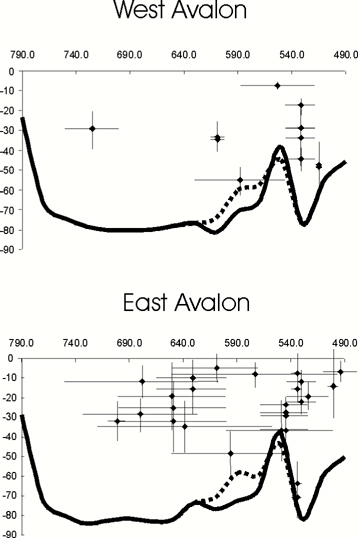 |
| Figure 6. Paleolatitudes of West (representative point 46 N, 60 W) and East Avalon (52 N, 0 E) predicted by reconstructions on Figs.2-5. Solid lines - high-latitude model, dashed lines - low-latitude model. Magnetic paleolatitudes (Q>2), result numbers from Global Paleomagnetic Database Ver. 3.6 (October, 2000) following McElhinny and Lock (1996) are: 121, 122, 409, 410, 411, 798, 799, 801, 868, 1000, 1001, 1130, 1242, 1339, 1340, 1341, 1342, 1345, 1347, 1649, 1747, 1748, 1753, 2157, 2158, 2390, 2943, 3528, 3737, 3738, 3802, 6035, 6036, 6037, 6038, 6039, 6040, 6041. |
Although there is general consensus that the amalgamation and subsequent dispersal of the supercontinent Rodinia profoundly influenced the evolution of Earth systems in the Neoproterozoic, the configuration is controversial.
We present four animations for the crucial time interval between 800 and 495 Ma that examine the potential geodynamic linkages between the tectonothermal evolution of peri-Gondwanan terranes and Laurentia-Amazonia-Baltica continental configurations. Each animation has several simplifying assumptions and some critical uncertainties. However, using the Mesozoic-Cenozoic breakup of Pangea as a modern analogy, serve to do focus attention on potential geodynamic linkages between regional tectonothermal events. The most critical uncertainty is the paleolatitude of Laurentia (and by implication, Amazonia) at ca. 570 Ma. For example, the high latitude and a low latitude options for Laurentia at this time allow very different geodynamic interpretations for the evolution of peri-Gondwanan terranes and the opening of the Iapetus Ocean.
Such reconstructions also focus attention on uncertainties in the database. For example, relatively reliable paleomagnetic data (according to the criteria of Van der Voo, 1988) older than 600 Ma for the peri-Gondwanan terranes yield lower paleolatitudes than those predicted by our models. This suggests that either Laurentia-Amazonia had complicated plate motions between 720 and 615 Ma, or the Laurentia-West Gondwana-Avalonia configurations shown on many reconstructions is incorrect.
Acknowledgments: JBM is grateful for the support of the Natural Sciences and Engineering Research Council Canada, University Council of Research, St. Francis Xavier University, and a Visiting Senior Gledden Fellowship, Tectonics Special Research Centre, University of Western Australia. SPA thanks The University of Western Australia for a Visiting Senior Gledden Fellowship. Reconstructions were made in the Western Australian Geotectonic Mapping facility co-funded by the Government of Western Australia (Office of Industry and Innovation) using the PLATES reconstruction program of the University of Texas at Austin, Texas, and Generic Mapping Tools of P.Wessel and W.H.F. Smith. This project was also supported by grants from the Program for North American Mobility in Higher Education, by a Programa de Apoyo a Proyectos de Investigacin e Innovacin Tecnolgia (PAPIIT) grant (IN116999) to J.D.K., and by the James Chair of Pure and Applied Sciences at St. Francis Xavier University to R.D.N and J.D.K.. The paper is a contribution to International Geological Correlation Programme Project 453. Tectonic Studies Research Centre Publication No. 190.