South Australian Three-dimensional Geological Models
Two, three-dimensional models were constructed, the first of which (upper crustal-level) occupies a spatial window on the Australian Map Grid orthogonal to (50000mE, 7000000mN) and (1000000mE, 6200000mN), the second model covering an area from (-100000mE, 7100000mN) to (1100000mE, 6400000mN).
South
Australian Upper crustal-level Surface Model
All surfaces were created to honour the geological data, the ascribed
delineation of gravimetric features and cross-sectional interpretations
of the kind shown in figures 5 to 8. Lithological variations in the
shallow-level geology were simplified into an assemblage of 18 units.
These include;
• the lower boundaries of the Gawler Range Volcanics and comagmatic
Hiltaba Suite Granitoids;
• the lower boundaries of the Cariewerloo Basin, Stuart Shelf
and Adelaidean Fold Belt;
• the lower boundaries of the Willyama and Mount Painter Inliers;
• the lower boundaries of accretionary complexes of the Peake
& Denison Inlier, the Mount Woods Inlier, the Mabel Creek Ridge,
the Ifould Complex and the Lincoln Complex;
• the lower boundaries of the Hutchison Group, the St Peters Suite
Granitoids and Moondrah Gneiss;
• the lower boundaries of the Musgrave Block and Undifferentiated
Precambrian rocks.
Several
additional features were created to define important lithospheric elements.
These include:
• the boundaries of the Gawler craton;
• the lower boundaries of the sub-crustal lithospheric mantle
(SCLM);
• the lower boundaries of the lower crust;
• the Kimban Suture Zone;
• a regional-scale mafic underplate;
The macroscopic nature of interpreted subsurface geological features of the Gawler Craton and surrounding environs are shown in figures 10 & 11.
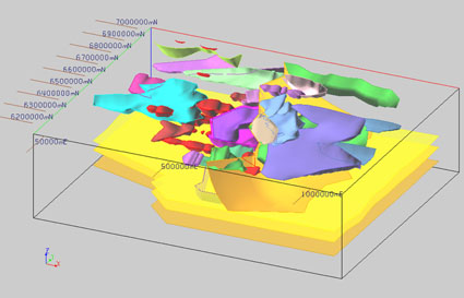 |
| Figure 10. gOcad three-dimensional surface representation of upper crustal-level structures of the South Australian model. View is towards N335 at 25 degrees elevation. (Click here to view 3D gOcad™ model; VRML plugin available at http://www.parallelgraphics.com/) |
These
figures enable conceptual visualisation of the complex geometry of the
Gawler Craton in which the following significant features are observable:
• the relatively large volume of rock occupied by the Gawler Range
Volcanics;
• the widespread spatial distribution of the Hiltaba Suite Granitoids;
• the geometry of accretionary terranes and their relative orientations
on the cratonic margins
• the geometry of the eastern cratonic margin.
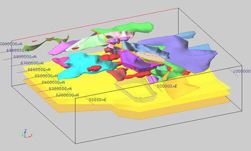 |
| Figure 11. gOcad three-dimensional surface representation of upper crustal-level structures of the South Australian model. View is towards N025 at 25 degrees elevation. |
South
Australian Deeper crustal-level Surface Model
Lithospheric variations in the deeper-level geology were simplified
into an assemblage of 13 blocks (Figures 12 & 13). These include;
• the boundaries of the Gawler Craton in the north and west and
the Kimban Suture Zone defining the eastern margin;
• the boundaries of the eastern, western and lower cratonic elements;
• the lower boundaries of the Fowler Orogenic Belt as delineated
by blocks defined by the Coorabie Fault, the Karari Fault Zone and units
of undifferentiated Pre-Cambrian Rocks;
• the lower boundaries of the Musgrave Block and the Officer Basin;
• the lower boundaries of the ‘reworked’ Torrens Hinge
Zone along the eastern margin of the Gawler Craton;
• the upper boundaries of a possible high-density displaced crustal
block beneath the Adelaidean Fold Belt.
 |
| Figure 12. gOcad three-dimensional surface representation of the deeper crustal-level structures of the South Australian model. View is towards N335 at 25 degrees elevation. |
 |
| Figure 13. gOcad three-dimensional surface representation of the deeper crustal-level structures of the South Australian model. View is towards N025 at 25 degrees elevation. |