Integrated Geological and Geophysical Modelling
There are many software packages designed to create three-dimensional geological models. It is not uncommon to find modelling packages specifically developed within a particular market, such as mine planning or seismic and basin analysis. The strengths and weaknesses of each usually reflect its origin. It has been necessary within the course of this investigation to combine the capabilities of more than one of the standard geology packages, which has involved using additional modules or ‘plug-ins’ developed in-house (Aillères, 2000). An approach involving the application of one geoscientific information system (MapInfo™) and three standard modelling packages (GM-SYS™, gOcad™ & Noddy™) was adopted.
GM-SYS™-
2D & 2 3/4D Modelling
The GM-SYS™ modelling system is a two-dimensional forward modelling
program for calculating the gravity and magnetic response of a geologic
model. The system allows for interactively creating and manipulating
models to match the observed gravity and or magnetic data by; (i) changing
the selected modelling parameters; and or (ii) by adjusting the model
geometry. All geological bodies are modelled in the third dimension
as dipping prisms of finite strike length in either 2 or 2 3/4 dimensions.
gOcad™
– Geological Objects Computer Aided Design
The gOcad™ modelling system is a data-based, three-dimensional
modelling package that integrates external information through an object-oriented
approach (Mallet, 1992). The three-dimensional modelling environment
of gOcad™ allows representation and definition of sophisticated
models that are topologically and geometrically consistent with many
types of external geological information including, drillholes, level
plans and cross-sections, seismic lines. The modelling framework allows
for interactive manipulation, interpretation and visualisation of geological
models comprising two basic model-types relevant to this investigation;
(i) surface-type models representing geological and or structural boundaries;
and (ii) grid-type models in which physical rock properties may be characterised
in the defined model space. (Click here to view 3D
gOcad™ model; VRML plugin available at http://www.parallelgraphics.com/)
Noddy™
The Noddy™ modelling system is a knowledge-based, three-dimensional
kinematic forward modelling package that evolves on information of an
a priori level of understanding (Jessell, 1997b). The system
allows for construction of conceptual geological models and calculations
of a geophysical response (Jessell et al., 1993). The Noddy™ package
enables the development of complex structural histories. A three-dimensional
model can be constructed through the superposition of a series of deformations
on an initial layer-cake stratigraphy. The potential field response
of the modelled three-dimensional geometry can be calculated (Jessell
et al., 1993; Jessell, 1997a).
Three-dimensional
modelling procedure
The procedure for three-dimensional modelling of lithospheric-scale
structures of South Australia in this investigation involves several
stages. The modelling operation is depicted in Figure 3 and is briefly
outlined below:
• Stage 1 – 2 3/4D gravity modelling: The first
activity of this stage involves extracting gravimetric profiles from
the South Australian Bouguer gravity field map and importing them into
the GM-SYS™ software. External constraints such as rock outcrop
and drillhole information from the South Australian Geoscientific GIS
dataset are then integrated to create a geological model for each profile.
• Stage 2 – Surface modelling: GM-SYS™ models
are exported into formats compatible with gOcad™. The next phase
involves the creation of opened or closed surfaces from the finite set
of points generated from the GM-SYS™ models. The creation of a
surface is strongly influenced by the set of control points, in which
case, multiple scenarios must be examined to determine the best fit
to both the data and geological understanding. The resultant surface
model is built up gradually through interpolation between each profile,
the effect of which provides a self-consistency test of the two-dimensional
interpretations.
• Stage 3 – Grid modelling: This involves generation
of a rectilinear grid model that encompasses the continuous volume of
the gOcad™ surfaces. The volume elements within the grid model
are directly analogous to the surface model and represent the in-fill
volume of the generated polyhedra. From this three-dimensional model,
a synthetic gravimetric field model is calculated through Noddy™
by assigning rock density values to the modelled regions.
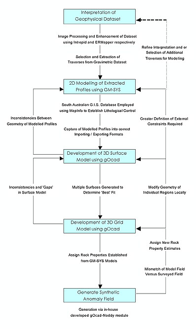 |
| Figure 3. Schematic diagram showing the modelling operation used in this investigation. |
Dominant
Gravimetric Features
A number of relatively high gravimetric anomalies correspond to numerous
crustal Palaeo- to Meso-proterozoic blocks (terranes) along the northern
and western margins of the Archaean craton. These terranes have a distinctive
gravimetric signature that can be mapped on the regional datasets and
include the Mount Woods Inlier, the Peake and Denison Inlier, the Coober
Pedy Ridge, the Mabel Creek Ridge and parts of the Ifould Complex (see
Figure 2). A brief description and analysis of dominant gravimetric
features of the Gawler Craton and its surrounds is given below.
Coober
Pedy Ridge
The Coober Pedy Ridge is a large thrust-related, fault bounded elongated
structural sliver of continental crustal that lies unexposed in the
northern central Gawler Craton (see Figure 2). This geophysically distinct
terrane is characterised by a relatively high gravimetric anomaly that
trends east-west and is cut by the regional-scale Karari Fault Zone
(Rankin et al., 1989). The source of this regional feature may be attributed
to the high iron content of supracrustal sequences comprising this crustal
block (Finley, 1993; Betts, 1999). The abrupt boundary truncations of
this gravimetric domain are manifested towards the northern and southern
margins where they are defined by several different generations of folded
thrusts (Betts, 1999). The consistently high amplitudes and short frequencies
of this gravimetric feature reflect a relatively shallow-level source
of the anomaly.
Mount
Woods Inlier
The Mount Woods Inlier forms a geophysically discrete crustal block
to the southeast margin of the Coober Pedy Ridge. It is characterised
by a relatively high gravimetric response predominantly in the western
domain from which a gradual easterly decrease in intensity is apparent
(see Figure 2). This is attributed to an increase in the burial depth
of the crustal block towards the east. The north-western boundary of
this block and the south-eastern boundary of the Coober Pedy Ridge are
separated by the east-west trending Cairn Shear (Betts, 1999).
Mabel
Creek Ridge
The Mabel Creek Ridge is a predominantly polygonal-shaped crustal block
situated immediately north of the Coober Pedy Ridge and is separated
by the Mabel Creek Fault (Betts, 1999). The gravimetric signature of
the Mabel Creek Ridge is dominated by a relatively moderate to high
elongated, northeast trending anomaly in the south-western quadrant
along the boundary with the Coober Pedy Ridge (see Figure 2). Towards
the central and northern regions, the response is relatively low and
is comparable in intensity to that of the background response of the
Mulgathing Complex of the Archaean nucleus.
Peake
& Denison Inlier
The Peake and Denison Inlier form an arcuate wedge of exposed Palaeoproterozoic
metasediments and metavolcanics immediately adjacent to the north-eastern
margin of the Gawler Craton (Flint, 1993b) (see Figure 2). The relatively
high, internally varying gravimetric expression trends northwest and
appears to form the northern part of a distinct broad northwest-southeast
trending regional gravity anomaly that intersects the Stuart Shelf and
parts of the north-western region of the Adelaidean Fold Belt.
Adelaidean
Fold Belt
The Adelaidean Fold Belt outlines a continuous expanse of thick Neoproterozoic
and Early Cambrian sedimentary sequences that extends from the south-eastern
to central-eastern parts of South Australia (Parker, 1993a). The regional
gravimetric response of the fold belt varies from relatively high to
very high in the south and eastern regions to relatively low to moderate
intensities in the central and north-western corner (see Figure 2).
The western margin of the Adelaidean Fold Belt is defined by the curvilinear
north-south trending Torrens Hinge Zone (Thomson, 1970), which is interpreted
to represent the eastern margin of the Gawler Craton. The eastern and
north-eastern margins of the fold belt are in spatial relation with
the Curnamona Craton (Thomson, 1975) and associated supracrustal sequences
of the Willyama, Mount Painter and Mount Babbage Inliers.
Gawler
Range Volcanic Province
The central Gawler Craton exhibits a relatively low intensity, long
wavelength and massive regional gravimetric anomaly in close spatial
association with the Gawler Range Volcanics (see Figure 2). This relatively
deep-level feature is suggested to represent a mafic body associated
with underplating during partial melting of the lower crust (Creaser
& White, 1991) and subsequent emplacement of the Hiltaba Suite Granitoids.
Fowler
Orogenic Belt
The Fowler Orogenic Belt encompasses a large region of the western-central
Gawler Craton and is predominantly composed of multiphase plutons of
the Ifould Complex.