Introduction
Quantitative studies of potential field data have largely revolved around two-dimensional forward modelling of source geometries and depths using a variety of graphical techniques (Talwani, 1965; Bhattacharyya, 1966; Naudy, 1971; Hjelt, 1972; Nabighian, 1972; Spector & Grant, 1975; Coggon, 1976; Gunn, 1979; Oliva & Ravazzoli, 1997; Stavrev, 1997). The usefulness of such models can provide rapid and relatively accurate information of anomalies in the third dimension and other value-specific detailed estimates of the source geometry. A more comprehensive and realistic model representation of the geology of structures requires understanding the 3D geometry.
The focus of this investigation involves the forward modelling of gravimetric field data in both two- and three-dimensions to develop and test a three-dimensional geological and geophysical model of lithospheric-scale structures of South Australia.
Little
is known about the lithospheric architecture and continental-scale structures
across the Gawler Craton. This investigation aims to:
1. Define the geometry and structure of the crustal-scale
architecture of the South Australian continent.
2. Define the structural and geophysical boundaries
of the Gawler Craton.
3. Determine the origin of various gravimetric anomalies.
The Gawler Craton is an Archaean to Mesoproterozoic-aged crystalline basement of sedimentary, metamorphic and igneous complexes that underlies the greater part of central South Australia (Parker et al., 1993a). The craton forms a highly polygonal-shaped continental nucleus surrounded by faulted margins of Neoproterozoic and Phanerozoic basins to the northeast, northwest and western boundaries (Daly & Fanning, 1993) (Figure 1). The eastern and southeastern boundaries of the craton are delineated by the variable north-south trending Torrens Hinge Zone. The edge of the continental shelf marks the southern boundary of the Gawler Craton.
The Gawler Craton experienced a protracted evolution of crustal formation and tectonothermal events. The earliest of these events occurred during the protracted late Archaean to Early Proterozoic poly-deformation, regional granulite facies metamorphism and syn- to late orogenic granitic intrusions during the Sleafordian Orogeny (~2635-2450 Ma: Daly & Fanning, 1993). These sequences of metasedimentary, granitic and intrusive rocks are recorded in limited exposures of basement outcrop of the Sleaford and Mulgathing Complexes (Daly et al., 1998).
A period of collisional orogenesis followed and involved the accretion of supracrustal sequences onto the Archaean nucleus during Palaeo- to Meso-proterozoic events. The earliest of these tectonic events is termed the Kimban Orogeny (~1730-1700 Ma: Parker et al., 1993a; Vassallo and Wilson, 2002) and involved the deposition of shallow continental shelf sequences of the Hutchison Group, which are predominantly exposed on the eastern cratonic margin. The emplacement of syntectonic, complex granitoids and mafic intrusions referred to collectively as the Lincoln Complex (Parker et al., 1993b) occurred before and during this orogenic event (see Figure 1).
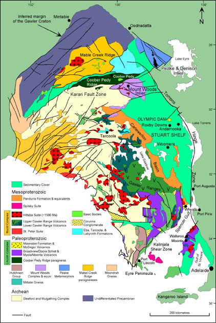 |
| Figure 1. Tectonic map of the Gawler Craton (after Daly et al., 1998). |
Deformation of supracrustal rocks occurred periodically and continued in the northern and western parts of the Gawler Craton. The Mount Woods Inlier and equivalent complexes (~1740-1650 Ma: Fanning, 1997) were deformed along the northern margin of the craton. Contemporaneous with this accretionary event was the emplacement of deformed, multiphase plutons of the Ifould Complex on the western margin of the craton (Daly et al., 1998) (see Figure 1). Supracrustal rocks of the Ifould Complex are preserved in the Fowler Orogenic Belt, which exhibits complex anastomosing north to northeast trending shear zones similar in orientation to the regional-scale Karari Fault Zone (Daly et al., 1998).
At approximately 1600 Ma, an extensive magmatic thermal event occurred and resulted in the deposition of anorogenic magmas of the Gawler Range Volcanics in the central Gawler Craton (Flint et al., 1993) (see Figure 1). Co-magmatic with this event was the emplacement of the dominantly felsic Hiltaba Suite Granitoids (~1600-1580 Ma) (Creaser & White, 1991; Blissett et al., 1993; Flint, 1993a). This massive magmatic province has undergone little deformation and is overlain unconformably by the Mesoproterozoic Cariewerloo Basin and Neoproterozoic to Cambrian platformal sediments of the Stuart Shelf in the eastern and northeastern parts of the craton (Cowley, 1993; Priess et al., 1993).
The continuation of continental accretion progressed in the northern Gawler Craton following plutonism associated with the Hiltaba Suite Granitoids. Orogenesis is recorded in the Coober Pedy Ridge (~1565 Ma: Daly et al., 1998) and the Mabel Creek Ridge (~1540 Ma) (see Figure 1), Collectively this event is termed the Late Kararan Orogeny (Betts, 2002). Orogenesis is characterised by poly-deformational and high-temperature metamorphic-grade conditions (Daly et al., 1998). The Mabel Creek Ridge is thought to have developed under a thin-skinned tectonic regime with deformation more intense in the Coober Pedy Ridge (Daly et al., 1998; Betts, 2000).