Digital terrestrial photogrammetry has been developed to create 3-D surface models of well exposed cliff sections of outcrop analogues. Ground-based, overlapping photographs are taken orthogonally to the cliff section, with control provided by standard surveying techniques, mirroring the aerial photogrammetric method (Pringle et al. in review). Figure 4 shows a surface model generated using this technique of Upper Carboniferous Shale Grit Formation turbidites in Derbyshire, UK. Once the model has been generated, it can easily be analysed in stereo from as many viewpoints as desired. A digitising option in the photogrammetric software allows rapid acquisition of sedimentological surface measurements in 3-D, to accuracies of a few centimetres. Cliff-sections may be studied from viewpoints that a ground-based geologist cannot occupy, e.g. along a plane parallel to bedding. This minimises potential interpretation errors and aids the correlation of sedimentary units.
The terrestrial cliff model shown in Figure 4 has been rotated to its correct geo-referenced location and merged with aerial photogrammetric data to create a Digital Outcrop Model (DOM). This has the advantage of combining top surface, regional geological features with detailed geology from vertical cliff sections.
Figure 4. Terrestrial photogrammetry 3-D digital model
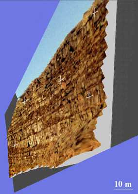
Terrestrial photogrammetry has produced a 3-D digital model of a cliff exposure of Upper Carboniferous, sand-rich turbidite deposits of the Shale Grit Formation, Derbyshire, UK. Total Station Points obtained using standard surveying techniques are shown as white crosses, which provide the control necessary for the photogrammetric software to produce the models.